

- Usage in publication:
-
- Kootznahoo Formation*
- Modifications:
-
- Named
- Dominant lithology:
-
- Conglomerate
- Sandstone
- Siltstone
- Shale
- Coal
- AAPG geologic province:
-
- Alaska Southeastern region
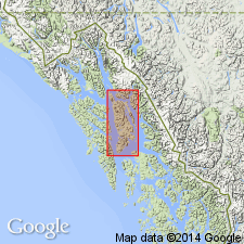
Summary:
Named for Kootznahoo Inlet, southeastern AK, along which typical exposures may be seen. Mainly occupies lowland bounded by Favorite Bay, Kanalku Bay, Davis Creek, and Mitchell Bay on west, southeast, and east, and low foothills northwest of Kootznahoo Inlet and Mitchell Bay. Also mapped from Little Pybus Bay to Cannery Cove. Composed of about 5000 ft of conglomerate, sandstone, siltstone, shale, and coal. Formation believed to be wedge shaped, thickest area occurring southeast of Kootznahoo Inlet. Thickness is about 2000 ft at Little Pybus Bay; thins northward. Overlies with angular unconformity Gambier Bay Formation at south end of Kanalku Bay and overlies Seymour Canal Formation (of Stephens Passage Group, new) at Little Pybus Bay. In Kootznahoo Inlet, unconformably overlies plutonic rocks. In type area, upper surface is erosional; no younger bedded rocks occur. In Little Pybus Bay area, conformably underlies Admiralty Island Volcanics. On basis of fossil evidence is considered Paleocene through Miocene age.
Source: GNU records (USGS DDS-6; Menlo GNULEX).
- Usage in publication:
-
- Kootznahoo Formation*
- Modifications:
-
- Areal extent
- AAPG geologic province:
-
- Alaska Southeastern region
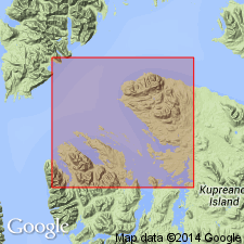
Summary:
Mapped in belt extending across Keku Strait from Kadak Bay to head of Hamilton Bay in basin between Kupreanof and Kuiu Islands. Thickness is probably 1500 ft. Rests unconformably on Hound Island Volcanics (new) and on Cannery Formation, but contact with Seymour Canal Formation obscured by gabbro intrusion.
Source: GNU records (USGS DDS-6; Menlo GNULEX).
- Usage in publication:
-
- Kootznahoo Formation*
- Modifications:
-
- Age modified
- AAPG geologic province:
-
- Alaska Southeastern region
Summary:
Kootznahoo Formation on Admiralty Island is now considered to be Eocene to Miocene age, on basis of plant fossils in sandstone beds (Wolfe, 1966; Wolfe, written commun., 1979; 1983).
Source: GNU records (USGS DDS-6; Menlo GNULEX).
- Usage in publication:
-
- Kootznahoo Formation*
- Modifications:
-
- Age modified
- AAPG geologic province:
-
- Alaska Southeastern region
Summary:
Type Kootznahoo Formation on Admiralty Island is now considered latest Eocene through early Miocene age. Near Keku Strait unit is Paleocene and on Zarembo Island is early Eocene.
Source: GNU records (USGS DDS-6; Menlo GNULEX).
For more information, please contact Nancy Stamm, Geologic Names Committee Secretary.
Asterisk (*) indicates published by U.S. Geological Survey authors.
"No current usage" (†) implies that a name has been abandoned or has fallen into disuse. Former usage and, if known, replacement name given in parentheses ( ).
Slash (/) indicates name conflicts with nomenclatural guidelines (CSN, 1933; ACSN, 1961, 1970; NACSN, 1983, 2005, 2021). May be explained within brackets ([ ]).