The National Geologic Map Database is migrating to a new infrastructure. We apologize for any service disruptions during this process.
|
|---|


- Usage in publication:
-
- Kintla argillite*
- Modifications:
-
- Original reference
- Dominant lithology:
-
- Argillite
- Quartzite
- AAPG geologic province:
-
- Northern Rocky Mountain region
Summary:
Pg. 316, 324. Kintla argillite. Argillite and quartzite, thin-bedded, maroon red, ripple-marked, sun-cracked, containing casts of salt crystals, also occasional beds of white quartzite and some calcareous beds. Thickness 800+ feet. No upper limit seen. Is top formation of Algonkian. Younger than Shepard quartzite. Closely resembles Grinnell argillite. Age is pre-Cambrian (Belt).
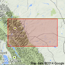
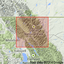
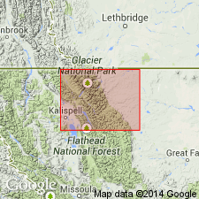
Named from occurrence in mountains on 49th Parallel northeast of Upper Kintla Lake, Glacier National Park, Flathead Co., northwestern MT.
Source: US geologic names lexicon (USGS Bull. 896, p. 1103).
- Usage in publication:
-
- Kintla formation
- Modifications:
-
- Areal extent
- AAPG geologic province:
-
- Northern Rocky Mountain region
Summary:
Areally extended by mapping northward into BC in the Northern Rocky Mountain region as the upper formation (of 8) of the Lewis series. Conformably overlies Shepard formation of Lewis series. Its top is eroded. Is a very conspicuous formation. Occurs above tree-line. Has a deep-red color so that it contrasts with buff beds of the Shepard. A section 860 ft thick described as near Kintla Lake, Flathead Co, MT where formation divided into (ascending): 60 ft thick thin-bedded red argillite with thin intercalations of quartzite; 40 ft of lava [Purcell lava?]; 300 ft of thin-bedded red argillite, gray and brown sandstone, oolitic and gray concretionary limestone; 460 ft of thin-bedded red, purple, brown argillite and subordinate quartzitic sandstone. Abundant salt crystals, ripple marks, sun cracks. Geologic map. Assigned to the Middle Cambrian?.
Source: GNU records (USGS DDS-6; Denver GNULEX).
- Usage in publication:
-
- Kintla member
- Modifications:
-
- Revised
- AAPG geologic province:
-
- Northern Rocky Mountain region
Summary:
Kintla member of Boulder Pass formation. Near Boulder Pass, south of Ahern Pass (Glacier National Park, northwestern Montana), consists of red to brown, thin-bedded argillite interbedded with varicolored sandstones and quartzites. Limestone beds occur about 100 feet above base. Ripple marks, mud cracks, and casts of salt crystals are common in upper 460 feet. Contains 40 to 60 feet of amygdaloidal lava. Thickness 890 feet. Overlies Shepard member of Boulder Pass. Age is pre-Cambrian (Belt).
[See 1931 entry under Boulder Pass.]
Source: US geologic names lexicon (USGS Bull. 896, Boulder Pass entry p. 241); GNU records (USGS DDS-6; Denver GNULEX).

- Usage in publication:
-
- Kintla member
- Modifications:
-
- Revised
- AAPG geologic province:
-
- Northern Rocky Mountain region
Summary:
Pg. 1901-1902. Kintla member of Miller Peak formation. Consists of argillites and argillaceous sandstones, thinly bedded, dominantly bright red; thin beds of quartzite and pinkish-gray limestone. Contains 30 to 40 feet of purplish amygdaloidal lava. Ripple marks, mud cracks, channels, rain prints, and casts of salt crystals characteristic. Thickness 860 to 900 feet. Underlies Roosville member; overlies Shepard formation. Age is Precambrian (Belt). Type locality and good exposures cited.
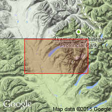
Type locality stated to be the pyramidal peaks of Akamina Ridge, west of Waterton Lakes National Park, [British Columbia, Canada]. Also well exposed on Mount Rowe, Mount Carthew, Mount Custer, and on Boulder Peak.
Source: US geologic names lexicon (USGS Bull. 1200, p. 2026).
- Usage in publication:
-
- Kintla formation
- Modifications:
-
- Areal extent
- AAPG geologic province:
-
- Northern Rocky Mountain region
Summary:
Pg. 62, chart facing p. 62. Kintla formation. In Glacier National Park area, only 860 feet of Missoula group is present, represented by Kintla formation, a red argillite which occurs in Kintla Lake area in northwestern part of park. Age is Precambrian (Belt).
Source: US geologic names lexicon (USGS Bull. 1200, p. 2026).
- Usage in publication:
-
- Kintla argillite*
- Modifications:
-
- Not used
- AAPG geologic province:
-
- Northern Rocky Mountain region
Summary:
Pg. 43-44. Kintla argillite. Willis (1902) proposed name Kintla argillite for part of Belt series above Shepard formation in northern part of Glacier National Park. He observed thickness of 800 feet and, because he saw no beds above his Kintla, assigned no upper limit. It is now known that Missoula group extends thousands rather than hundreds of feet above Purcell basalt. Because there is no way of separating Kintla argillite of Willis from similar beds at horizons above those he saw, name Kintla not useful at present.
Source: US geologic names lexicon (USGS Bull. 1200, p. 2026).

- Usage in publication:
-
- Kintla argillite*
- Modifications:
-
- Overview
- AAPG geologic province:
-
- Northern Rocky Mountain region
Summary:
Type locality of Kintla argillite: Willis gives it as pyramidal peaks on 49th parallel, at head of Kintla drainage [Glacier National Park, Montana]. Fenton and Fenton give pyramidal peaks of Akamina Ridge, west of Waterton Lakes National Park [British Columbia, Canada]. Well exposed on Mount Rowe, Mount Carthew, Mount Custer, and on Boulder Peak.
Source: US geologic names lexicon (USGS Bull. 1200, p. 2026).
- Usage in publication:
-
- Kintla Group
- Modifications:
-
- Revised
- AAPG geologic province:
-
- Northern Rocky Mountain region
Summary:
Raised to group rank in the southwest Marias Pass area, Flathead Co, MT in Northern Rocky Mountain region. Divided into Shields Formation (basal unit) and Red Plume Quartzite (upper unit), both named in this report.
Source: GNU records (USGS DDS-6; Denver GNULEX).

- Usage in publication:
-
- Kintla Argillite†
- Modifications:
-
- Abandoned
- AAPG geologic province:
-
- Northern Rocky Mountain region
Summary:
Pg. 1219; figs. 3, 4, 5, 6. †Kintla Argillite of Missoula Group of Belt Supergroup (MT); †Kintla Argillite of Missoula Group of Purcell Supergroup (Canada). Abandoned. Has been used for one or more units of Missoula Group. In Glacier National Park area, northwestern Montana, its rocks reassigned to lower part of Mount Shields Formation; elsewhere its rocks included in parts of Miller Peak, Striped Peak, and Mount Shields Formations.
[Adopted by the USGS (see Changes in stratigraphic nomenclature, 1972, USGS Bull. 1394-A, p. A22-A23).]
Source: Publication; Changes in stratigraphic nomenclature, 1972 (USGS Bull. 1394-A, p. A22-A23).
For more information, please contact Nancy Stamm, Geologic Names Committee Secretary.
Asterisk (*) indicates published by U.S. Geological Survey authors.
"No current usage" (†) implies that a name has been abandoned or has fallen into disuse. Former usage and, if known, replacement name given in parentheses ( ).
Slash (/) indicates name conflicts with nomenclatural guidelines (CSN, 1933; ACSN, 1961, 1970; NACSN, 1983, 2005, 2021). May be explained within brackets ([ ]).