

- Usage in publication:
-
- Kincaid formation*
- Modifications:
-
- Original reference
- AAPG geologic province:
-
- Ouachita folded belt
Summary:
Pg. 744. Kincaid formation, lower formation of Midway group. Probably 100+/- feet thick in Frio River section. Includes beds 7 to 5 of Vaughan's section of "Myrick formation" on Frio River, about 0.25 miles above Myrick's lower apiary (now Bob Evans apiary), as given in USGS Uvalde folio, No. 64, 1900. The Kincaid formation in that section consists of (descending): (7) rather soft yellowish sandstone, 22 feet 6 inches; (6) soft yellow sandy clay with bluish streaks, some pebbles in lower part, 2 feet 6 inches; (5) nodules of glauconitic sandstone containing considerable number of small pebbles, 6 inches. Underlies Wills Point formation [restricted] and unconformably overlies Escondido formation (Upper Cretaceous). Age is early Eocene.
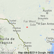
Type exposures are on old Kincaid Ranch (Lewis Ranch) 0.75 mi above Bob Evans' apiary to 0.25 mi below it, [approx. Lat. 29 deg. 16 min. 44 sec. N., Long. 99 deg. 56 min. 06 sec. W., Chalk Bluff 7.5-min quadrangle, Uvalde Co.], eastern TX. [Lat./Long. coords. from USGS GNIS database and ACME Mapper 2.0, accessed August 19, 2009.]
Source: US geologic names lexicon (USGS Bull. 896, p. 1095-1096).

- Usage in publication:
-
- Kincaid Formation
- Modifications:
-
- Mapped 1:250k
- Dominant lithology:
-
- Clay
- Limestone
- AAPG geologic province:
-
- East Texas basin
Summary:
Kincaid Formation of Midway Group. Mostly clay, calcareous, glauconitic, selenitic, in part silty and sandy, locally phosphatic near base, some thin beds of hard, gray limestone in upper part, various shades of gray; weathers medium-gray; marine megafossils. Thickness 150+/- feet. Lies above Upper Cretaceous Navarro Group, undivided, and below Wills Point Formation of Midway Group. Age is Paleocene.
[Mapped in southwestern corner of map sheet, west of Sulphur Springs, TX, in Hopkins and Hunt Cos., northeastern TX.]
Source: Publication.

- Usage in publication:
-
- Kincaid Formation
- Modifications:
-
- Mapped 1:250k
- Dominant lithology:
-
- Limestone
- Marl
- Sand
- Clay
- AAPG geologic province:
-
- East Texas basin
Summary:
Kincaid Formation [of Midway Group]. Basal formation of Midway Group. Includes (descending) Tehuacana Member, and [undifferentiated] Pisgah and Littig Members. Lies above Upper Cretaceous Kemp Clay and below Wills Point Formation [of Midway]. Age is Eocene.
[Mapped in Falls, Limestone, and Navarro Cos., eastern TX. Not separately mapped south of Brazos River.]
Source: Publication.

- Usage in publication:
-
- Kincaid Formation
- Modifications:
-
- Areal extent
- AAPG geologic province:
-
- Gulf Coast basin
Summary:
Kincaid Formation of Midway Group. Includes (descending) Pisgah and Littig Members. Total thickness about 150 feet. Lies above Upper Cretaceous Navarro Group and below Wills Point Formation of Midway Group. Age is Eocene.
Not separately mapped. [Midway Group, undivided, mapped in Guadalupe and Caldwell Cos., southeastern TX.]
Source: Publication.
- Usage in publication:
-
- Kincaid Formation
- Modifications:
-
- Mapped 1:250k
- Dominant lithology:
-
- Clay
- Limestone
- AAPG geologic province:
-
- East Texas basin
Summary:
Kincaid Formation of Midway Group. Clay, medium gray to dark gray, greenish gray, brownish gray, glauconitic, calcareous, selenitic, locally silty or sandy, locally phosphatic near base, thin beds of limestone in upper part, gray, hard, detrital; weathers medium gray. Thickness 180+/- feet. Occurs below Wills Point Formation of Midway and above Upper Cretaceous Kemp Clay. Fossiliferous. Age is Eocene. [Age changed from Paleocene (1964 ed.).]
[Mapped in Hunt, Rains, and Van Zandt Cos., eastern TX.]
Source: Publication; supplemental information from GNU records (USGS DDS-6; Denver GNULEX).

- Usage in publication:
-
- Kincaid Formation
- Modifications:
-
- Mapped 1:250k
- Dominant lithology:
-
- Shale
- Sandstone
- Limestone
- AAPG geologic province:
-
- Gulf Coast basin
Summary:
Kincaid Formation. Shale, sandstone, and limestone; shale, glauconitic, fossiliferous, dark gray; sandstone, fine-grained, glauconitic, yellowish gray to greenish black; limestone, sandy, impure; phosphatic pebbles and sharks teeth common; poorly exposed. Thickness up to 300(?) feet. Lies above Upper Cretaceous Escondido Formation and below Indio Formation. Age is Eocene.
[Mapped in Maverick, Dimmit, and Zavala Cos., southwestern TX.]
Source: Publication.

- Usage in publication:
-
- Kincaid Formation
- Modifications:
-
- Mapped 1:250k
- Dominant lithology:
-
- Sand
- Clay
- Limestone
- AAPG geologic province:
-
- Ouachita folded belt
Summary:
Pamphlet [p. 4]. Kincaid Formation of Midway Group. Consists of (descending) Pisgah and Littig Members; not separately mapped. Pisgah Member, sand and clay; sand, glauconitic, poorly sorted, argillaceous, greenish gray; clay, sandy, silty, medium-gray to black. Littig Member, sand, clay, and limestone; sand very glauconitic, greenish black; clay, sandy, phosphatic nodules and pebbles present; limestone, very glauconitic, sandy, fossiliferous; weathers to yellow and yellowish brown soil; thickness 100+/- feet. Lies above Upper Cretaceous Navarro Group and Marlbrook Marl ("upper Taylor marl"), undifferentiated; lies below Indio Formation of Wilcox Group. Age is Eocene.
[Mapped as small outlier along tributary of Nueces River, southeast of Sulphur Mountain, southern Uvalde Co., southern TX; southwestern corner of map sheet.]
Source: Publication.

- Usage in publication:
-
- Kincaid Formation
- Modifications:
-
- Mapped 1:250k
- Dominant lithology:
-
- Limestone
- Marl
- Sand
- Clay
- AAPG geologic province:
-
- East Texas basin
Summary:
Kincaid Formation of Midway Group. Basal formation of Midway Group. Includes (ascending) Littig and Pisgah Members [undifferentiated; not separately described or mapped], and Tehuacana Member. Lies above Upper Cretaceous Kemp Clay and below Wills Point Formation of Midway. Age is Paleocene. [Age changed from Eocene (1972 ed.).]
[Mapped in Henderson, Hunt, Kaufman, Navarro, and Van Zandt Cos., eastern TX.]
Source: Publication; supplemental information from GNU records (USGS DDS-6; Denver GNULEX).

- Usage in publication:
-
- Kincaid Formation
- Modifications:
-
- Mapped 1:250k
- Dominant lithology:
-
- Clay
- Limestone
- AAPG geologic province:
-
- East Texas basin
Summary:
Pamphlet [p. 1]. Kincaid Formation [of Midway Group]. Mostly clay; various shades of gray, weathers to medium-gray, in part silty and sandy, calcareous, glauconitic, selenitic, locally phosphatic near base, some thin beds of well-indurated gray limestone in upper part; marine megafossils. Thickness approximately 150 feet. [Is basal formation of Midway Group. Underlies unnamed Quaternary fluviatile terrace deposits; overlies Upper Cretaceous Navarro Group, undivided.] Age is Paleocene.
[Mapped in southwestern corner of map sheet, east of Greenville, Hunt Co., northeastern TX.]
Source: Publication.
For more information, please contact Nancy Stamm, Geologic Names Committee Secretary.
Asterisk (*) indicates published by U.S. Geological Survey authors.
"No current usage" (†) implies that a name has been abandoned or has fallen into disuse. Former usage and, if known, replacement name given in parentheses ( ).
Slash (/) indicates name conflicts with nomenclatural guidelines (CSN, 1933; ACSN, 1961, 1970; NACSN, 1983, 2005, 2021). May be explained within brackets ([ ]).