The National Geologic Map Database is migrating to a new infrastructure. We apologize for any service disruptions during this process.
|
|---|


- Usage in publication:
-
- Kaiparowits formation*
- Modifications:
-
- Named
- Dominant lithology:
-
- Sandstone
- Conglomerate
- Shale
- Limestone
- AAPG geologic province:
-
- Plateau sedimentary province
- Paradox basin
Summary:
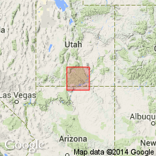
Name applied to beds above the Wahweap sandstone (first used) and beneath the Wasatch formation at Kaiparowits Peak and Table Cliff. Mapped west of the Kaiparowits Plateau in Kane Co, UT (Plateau sedimentary province) and adjoining Garfield Co (Paradox basin). No type locality designated. Thickness estimate 2,200 ft. Section 495 ft thick measured in the upper Wahweap valley at the southern outcrop limit shown on the geologic map. Consists of predominantly (451 ft) drab to brown sandstone that may be calcareous, unevenly bedded, dense, cross-bedded with some interbedded conglomerate of clay lumps, calcareous bullets, bits of limestone and petrified wood in a sandstone matrix, brown, hard, sandy limestone, and shale. The sandstone forms cliffs. Fossiliferous (oysters and vertebrates). Fauna is of Judith River and Fruitland age. A brackish-water deposit. Overlies Wahweap sandstone; underlies Wasatch formation. Of Late Cretaceous age.
Source: GNU records (USGS DDS-6; Denver GNULEX).
- Usage in publication:
-
- Kaiparowits Formation
- Modifications:
-
- Contact revised
- AAPG geologic province:
-
- Great Basin province
- Paradox basin
- Plateau sedimentary province
Summary:
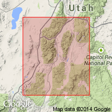
Upper contact revised where unit underlies newly named Cedar Breaks Formation. Overlying rocks in southern High Plateaus of south-central UT in area of Cedar Breaks National Park [Monument], Iron Co [Great Basin province] and Bryce Canyon National Park and along margins of Table Cliff Plateau, Garfield and Kane Cos [Paradox basin and Plateau sedimentary province] that were previously referred to as Wasatch Formation are now assigned to Cedar Breaks.
Source: GNU records (USGS DDS-6; Denver GNULEX).
- Usage in publication:
-
- Kaiparowits Formation*
- Modifications:
-
- Age modified
- Revised
- AAPG geologic province:
-
- Paradox basin
Summary:
Revised; unconformably underlies newly named Canaan Peak Formation on Table Cliff Plateau, Garfield County, Utah (Paradox basin). Is oldest unit studied. From palynomorphs, R.H. Tschudy (USGS) determined a Campanian age for lower part of Canaan Peak "which is older than the Maestrichtian (Lance or Hell Creek) age generally assigned to the underlying Kaiparowits Formation." Mollusk fossils from Kaiparowits were studied by J.B. Reeside, Jr. who assigned an age of middle to late Montana (approximately middle Campanian to Maestrichtian); other invertebrate fossils studied by Reeside and a small collection of fragmentary vertebrate material examined by C.W. Gilmore suggested a late Montana age. Report includes stratigraphic chart, cross sections, generalized geologic map.
Source: GNU records (USGS DDS-6; Denver GNULEX).
- Usage in publication:
-
- Kaiparowits Formation
- Modifications:
-
- Biostratigraphic dating
- AAPG geologic province:
-
- Paradox basin
- Plateau sedimentary province
Summary:
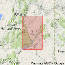
Study area is Kaiparowits Plateau located in south-central UT, Garfield and Kane Cos, Paradox basin and Plateau sedimentary province. Assigned middle and late Campanian age based on mammalian faunas and reevaluation of previously reported palynofloras. Combined results of palynological studies of Lohrengel (1969, B.Y.U. Geology Studies, v. 16, p.61-180) and Bowers (1972) indicate presence of AQUILAPOLLENITES TRIALATUS and A. TURBIDUS which are restricted to Campanian. Also mammalian fauna recovered from Kaiparowits are more similar to Campanian than Maastrichtian faunas. Stratigraphic chart; measured section. Underlies Canaan Peak Formation; overlies Wahweap Formation.
Source: GNU records (USGS DDS-6; Denver GNULEX).
- Usage in publication:
-
- Kaiparowits(?) Formation*
- Modifications:
-
- Areal extent
- Biostratigraphic dating
- AAPG geologic province:
-
- Plateau sedimentary province
Summary:
Is Upper Cretaceous formation tentatively identified in the Markagunt Plateau, Kane Co, southwestern UT (Plateau sedimentary province). Palynology indicates that the Kaiparowits(?) Formation in the Markagunt Plateau is older than the typical Kaiparowits Formation (Campanian) in the southern Kaiparowits Plateau. The Kaiparowits Formation in its type area in the Kaiparowits Plateau contains triprojectate pollen and other species characteristic of late Campanian age in the Rocky Mountain region. This assemblage, which is characteristic of the AQUILAPOLLENITES QUADRILOBUS Interval Zone, is absent from the Kaiparowits(?) Formation of the Markagunt Plateau. The Kaiparowits(?) of the Markagunt contains the assemblage of the PROTEACIDITES RETUSUS Interval Zone, which is Coniacian and Santonian in age.
Source: GNU records (USGS DDS-6; Denver GNULEX).
For more information, please contact Nancy Stamm, Geologic Names Committee Secretary.
Asterisk (*) indicates published by U.S. Geological Survey authors.
"No current usage" (†) implies that a name has been abandoned or has fallen into disuse. Former usage and, if known, replacement name given in parentheses ( ).
Slash (/) indicates name conflicts with nomenclatural guidelines (CSN, 1933; ACSN, 1961, 1970; NACSN, 1983, 2005, 2021). May be explained within brackets ([ ]).