

- Usage in publication:
-
- Jewett zone
- Modifications:
-
- Named
- Dominant lithology:
-
- Sand
- Siltstone
- AAPG geologic province:
-
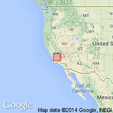
- San Joaquin basin
Summary:
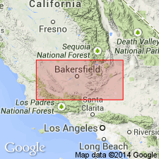
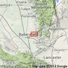
Jewett zone proposed for 50- to 550-ft " shaly sand zone" immediately overlying Vedder Sand in Round Mountain field Shell Oil Co Jewett No.1 well (sec.29 T28S R29E, Kern Co, CA). Operators at Mount Poso field borrowed name "Jewett".
Source: GNU records (USGS DDS-6; Menlo GNULEX).
- Usage in publication:
-
- Jewett Sand*
- Modifications:
-
- Adopted
- Biostratigraphic dating
- AAPG geologic province:
-
- San Joaquin basin
Summary:
Jewett Sand called "Jewett zone" Godde (1928) is adopted. Includes Pyramid Hill Sand Member at its base. Type section designated as 657 ft cored subsurface interval from 1218 to 1875 ft in Shell Oil Jewett No.1 well (sec.29 T28S R29E, Kern Co, CA). Diepenbrock (1933) used term "Jewett Silt Member" of Temblor Formation at Mount Poso field, and Diepenbrock (1934) used "Jewett Micaceous Silt Member" at 'Round Mountain field. Ferguson (1941) grouped Freeman-Jewett together. Lenses of sand overlying Pyramid Hill Sand of (Wilson 1935) are recognized as Jewett Sand in some oil fields along eastern margin of San Joaquin Valley (Bailey, 1947). Unconformably overlies Walker or intervening Vedder Formation. Conformably underlies Freeman Silt. Age is early Miocene based on occurrence of pelecypods of Vaqueros Stage.
Source: GNU records (USGS DDS-6; Menlo GNULEX).
- Usage in publication:
-
- Jewett Sand*
- Modifications:
-
- Areal extent
- AAPG geologic province:
-
- San Joaquin basin
Summary:
Jewett Sand questionably extended to northwest to Coalinga-Kettleman Hills area based on data from three wells (Terra Resources Piexoto No.1, Canus Petroleum Hansen Farms No.1, and Chevron USA Mills 58-8).
Source: GNU records (USGS DDS-6; Menlo GNULEX).
For more information, please contact Nancy Stamm, Geologic Names Committee Secretary.
Asterisk (*) indicates published by U.S. Geological Survey authors.
"No current usage" (†) implies that a name has been abandoned or has fallen into disuse. Former usage and, if known, replacement name given in parentheses ( ).
Slash (/) indicates name conflicts with nomenclatural guidelines (CSN, 1933; ACSN, 1961, 1970; NACSN, 1983, 2005, 2021). May be explained within brackets ([ ]).