

- Usage in publication:
-
- Jacksonburg limestone*
- Modifications:
-
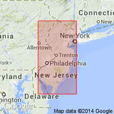
- Named
- Dominant lithology:
-
- Limestone
- Conglomerate
- AAPG geologic province:
-
- Appalachian basin
Summary:
Jacksonburg limestone. [Is] the limestones hitherto called Trenton limestone in New Jersey reports, but which contain fossils of Lowville [now (ca. 1938) included in Black River], Black River, and lower Trenton age. Thickness is 135 to 150 feet. Includes (descending): (1) calcareous shales; (2) dark blue or black fossiliferous limestones, 30 to 40 feet; (3) shaly beds, 30+/- feet; (4) dark blue or black fossiliferous limestones, 30 to 40 feet; and (5) basal conglomerate, a few inches to 50 feet. At Jacksonburg, Warren County, shales and thin-bedded shaly limestones 19 or 20 feet thick occur at base of section, overlain by 102 feet of limestone, and top of section is not seen. Underlies Martinsburg shale and unconformably overlies Kittatinny limestone. Age is Middle Ordovician.
Source: US geologic names lexicon (USGS Bull. 896, p. 1036).
- Usage in publication:
-
- Jacksonburg limestone*
- Modifications:
-
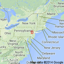
- Overview
- AAPG geologic province:
-
- Appalachian basin
Summary:
At the type locality, the Jacksonburg limestone consists of 135 ft of limestone, the lower 58 ft of which contain LEPERDITIA FABULITES and DOLEROIDES sp. cf. D. GIBBOSUS. These beds are probably of Rocklandian age. Remaining 77 ft is equivalent to the Hull and Sherman Fall formations. Unconformably overlies Kittatinny limestone and underlies Martinsburg shale with some disconformity. In main belt of Jacksonburg, LEPERDITIA zone has not been recognized, and near Stockertown the basal beds seem to be equivalent to the Hull. The Jacksonburg can be divided into two parts on basis of lithology, the lower being the "cement limestone" facies and the upper being the "cement rock" facies. "Cement rock" east of Schuylkill River, which has been called Leesport, is assigned to the Jacksonburg. The Jacksonburg is of Middle Ordovician age.
Source: GNU records (USGS DDS-6; Reston GNULEX).
- Usage in publication:
-
- Jacksonburg limestone
- Modifications:
-
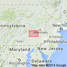
- Areal extent
- AAPG geologic province:
-
- Appalachian basin
Summary:
Geographically extended the Jacksonburg limestone into eastern PA. Name applied to all impure limestone in part formerly called Leesport lying between Annville or Beekmantown formation and Martinsburg formation. Thickness varies. Formation is absent in at least one area due to an erosional unconformity and elsewhere due to thrust-faulting. Intense folding and faulting and lack of large exposures make it difficult to estimate thickness. West of Womelsdorf, basal conglomeratic part of formation is estimated to be about 250 ft thick where fully developed and rest of formation may be as much as 750 ft thick. Whole formation disappears abruptly east of Womelsdorf, being hidden by thrust fault. Present in anticlinal embayment of Martinsburg shale northeast of Womelsdorf where basal conglomerate is absent and rest of formation is estimated to be not more than 700 ft thick. East of Schuylkill River and in bluffs 3 mi south of West Leesport, formation is more than 270 ft thick.
Source: GNU records (USGS DDS-6; Reston GNULEX).
- Usage in publication:
-
- Jacksonburg Formation
- Modifications:
-
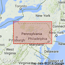
- Overview
- AAPG geologic province:
-
- Appalachian basin
Summary:
The Jacksonburg Formation in PA is part of the Lehigh Valley sequence and consists of dark-gray, shaly limestone (cement rock) having slaty cleavage and a basal medium- to thick-bedded limestone (cement limestone). Basal unit increases in thickness eastward. Overlies Ontelaunee Formation of Beekmantown Group and underlies the Martinsburg Formation.
Source: GNU records (USGS DDS-6; Reston GNULEX).
- Usage in publication:
-
- Jacksonburg Limestone
- Modifications:
-
- Overview
- AAPG geologic province:
-
- Appalachian basin
Summary:
Upper part of Jacksonburg, where present, is dark-gray to black, thin- to medium-bedded or massive, argillaceous limestone. Lower part is dark-gray, medium to coarse-grained limestone, medium-bedded, locally a fossil hash, and weathers medium-bluish-gray. Dolomite-cobble conglomerate may occur at the basal contact in the lower section of the lower facies. Formation approximately 80 ft thick. Lower contact is the Beekmantown unconformity. Underlies Martinsburg Formation. Age is Middle Ordovician.
Source: GNU records (USGS DDS-6; Reston GNULEX).

- Usage in publication:
-
- Jacksonburg Limestone*
- Modifications:
-
- Biostratigraphic dating
- AAPG geologic province:
-
- Appalachian basin
Summary:
Most samples of Jacksonburg Limestone contain North American Midcontinent Realm conodont species PHRAGMODUS UNDATUS, PLECTODINA TENUIS, APHELOGNATHUS POLITUS, as well as pandemic species such as PANDERODUS GRACILIS and DREPANOISTODUS SUBERECTUS. All of these species are long-ranging, but some constrain lower limit of Jacksonburg to an age no older than late Middle Ordovician (Kirkfieldian) PLECTODINA TENUIS Zone. Age of upper part of Jacksonburg is not well constrained; graptolites in lower part of overlying Martinsburg Formation indicate an age no younger than early Edenian.
Source: GNU records (USGS DDS-6; Reston GNULEX).
For more information, please contact Nancy Stamm, Geologic Names Committee Secretary.
Asterisk (*) indicates published by U.S. Geological Survey authors.
"No current usage" (†) implies that a name has been abandoned or has fallen into disuse. Former usage and, if known, replacement name given in parentheses ( ).
Slash (/) indicates name conflicts with nomenclatural guidelines (CSN, 1933; ACSN, 1961, 1970; NACSN, 1983, 2005, 2021). May be explained within brackets ([ ]).