

- Usage in publication:
-
- Complex of Iron Hill*
- Modifications:
-
- Areal extent
- AAPG geologic province:
-
- Southern Rocky Mountain region
Summary:
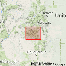
Two units southeast of Powderhorn, Ts46 and 47N, Rs1 and 2W, Gunnison Co, CO, Southern Rocky Mountain region are part of complex. First, limestone of Iron Hill, occurs in a mass 2 mi long 1 mi wide and as smaller bodies. Limestone is coarse grained and chiefly dolomite, and is fractured and cut by many iron oxide, cherty hematite, or apatite and martite veins; origin uncertain. May be a block of Cambrian limestone brought up by magma or of Paleozoic limestone dropped into stock, or a large hydrothermal body. Second, intrusives of Iron Hill, include: 1) uncompahgrite found only on Beaver Creek; 2) pyroxenite which makes up 80 percent of second unit intruding uncompahgrite and limestone and is composed of 75 percent pyroxene, 10 percent biotite; 5 percent apatite, magnetite, and perofskite; 3) ijolite which intrudes pyroxenite as dikes and as irregular masses, a coarse-grained rock, mostly of nepheline; 4) soda syenite in body north of North Beaver Creek and in several smaller bodies that cut pyroxenite; 5) nepheline syenite chiefly on Beaver Creek; 6) theralite and quartz gabbro in Deldorado Creek drainage; and 7) numerous veins a few ft across in long parallel group cutting other rocks of stock. Intrusives cut pre-Cambrian rock. Overlain by Miocene Potosi volcanic series. Jurassic sandstone near stock contains grains identified as from parts of stock. Pre-Entrada, but otherwise, age unknown.
Source: GNU records (USGS DDS-6; Denver GNULEX).
- Usage in publication:
-
- Alkalic rocks of Iron Hill*
- Modifications:
-
- Overview
- AAPG geologic province:
-
- Southern Rocky Mountain region
Summary:
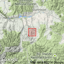
Occurs in a stock over 12 sq mi in Gunnison Co, CO in the Southern Rocky Mountain region. Intrudes pre-Cambrian granites. Is overlain by sandstone in the Morrison formation. Divided into 9 mapped units, listed oldest to youngest: limestone, uncompahgrite, pyroxenite, ijolite, nepheline syenite, soda syenite, carbonate veins, nepheline gabbro dikes, and quartz gabbro dikes. Chemistry of rocks discussed. Known to be younger than pre-Cambrian granites and older than Morrison.
Source: GNU records (USGS DDS-6; Denver GNULEX).
- Usage in publication:
-
- Complex of alkalic rocks of Iron Hill*
- Modifications:
-
- Age modified
- AAPG geologic province:
-
- Southern Rocky Mountain region
Summary:
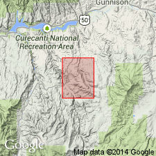
Assigned to the Cambrian or upper Precambrian. Divided into the following mapped units: melanite-orthoclase rock, pyroxenite, magnetite-ilmenite-perovskite dikes and segregations, ijolite, pyroxenite-nepheline syenite hybrid rock, nepheline syenite, and carbonatite. The pyroxenite has been dated by K-Ar method 2,500 m to north as about 574 +/-13 and 567 +/-12 m.y. from two samples. Mapped in southeast part of quad in Gunnison Co, CO in the Southern Rocky Mountain region.
Source: GNU records (USGS DDS-6; Denver GNULEX).
- Usage in publication:
-
- Alkalic igneous complex of Iron Hill*
- Modifications:
-
- Age modified
- AAPG geologic province:
-
- Southern Rocky Mountain region
Summary:
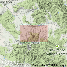
Cambrian or Late Proterozoic (rather than Cambrian or upper Precambrian) accepted on basis of isotopic ages given in Hedlund and Olson (1975) of 574 and 567 m.y. on the pyroxenite unit. Occurs in east part of map area in Gunnison Co, CO in the Southern Rocky Mountain region. Two mapped units: carbonatite and alkalic mafic rocks.
Source: GNU records (USGS DDS-6; Denver GNULEX).
For more information, please contact Nancy Stamm, Geologic Names Committee Secretary.
Asterisk (*) indicates published by U.S. Geological Survey authors.
"No current usage" (†) implies that a name has been abandoned or has fallen into disuse. Former usage and, if known, replacement name given in parentheses ( ).
Slash (/) indicates name conflicts with nomenclatural guidelines (CSN, 1933; ACSN, 1961, 1970; NACSN, 1983, 2005, 2021). May be explained within brackets ([ ]).