

- Usage in publication:
-
- Idaho Springs formation*
- Modifications:
-
- Named
- Dominant lithology:
-
- Schist
- Gneiss
- AAPG geologic province:
-
- Southern Rocky Mountain region
Summary:
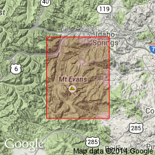
Name applied to the oldest pre-Cambrian unit of interbedded metamorphic crystalline rocks (of sedimentary origin) exposed in hills around town of Idaho Springs, Clear Creek Co, CO in the Southern Rocky Mountain region. No type locality designated. Includes biotite-sillimanite schist, biotite-schist, and quartz-gneiss, which are interbedded and gradational into one another, and lime-silicate rocks that grade only into the quartz gneiss. The biotite-sillimanite schist is foliated, often crenulated, fine grained, black (rusty weathering) in which biotite, quartz, feldspar, and sillimanite are recognizable megascopically, and in which muscovite, garnet, tourmaline, and corundum are sometimes prominent. This schist is injected lit-par-lit by pegmatitic rock. Biotite-schist is finer grained, gray, and has almost no muscovite and sillimanite. The quartz-gneiss is banded, dense, vitreous, gray, brown, red or black, and predominated by quartz over all other constituents. The silicate rocks include many intergradational facies--hornblende-augite-feldspar-gneiss, quartz-magnetite-gneiss, and several kinds of massive rocks (aggregates of quartz, epidote, garnet) and lime-silicate rocks. Metamorphism has destroyed the original texture. May represent intensely eroded shale, arkose, sandstone, conglomerate and limestone. Is older than an unnamed quartz monzonite gneiss.
Source: GNU records (USGS DDS-6; Denver GNULEX).
- Usage in publication:
-
- Idaho Springs formation*
- Modifications:
-
- Mapped 1:24k (Golden quad, Jefferson Co, CO)
- Dominant lithology:
-
- Gneiss
- Schist
- Quartzite
- AAPG geologic province:
-
- Southern Rocky Mountain region
Summary:
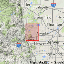
Is Precambrian lithodeme mapped in northern Jefferson Co, CO (Southern Rocky Mountain region). Is oldest exposed unit in quad; underlies Fountain formation (Pennsylvanian) with an angular unconformity. Outcrops in southwestern corner of map. Consists primarily of granite gneiss, hornblende gneiss, garnet gneiss, quartzite, and schist which have been intruded by pegmatite and biotite syenite dikes. North of Tucker Gulch rocks are mainly gneiss and schist; south of Tucker Gulch they are mainly granite gneiss. Garnet gneiss, 15-25 ft thick, occurs on north wall of Clear Creek canyon and in Tucker Gulch; garnet crystals range from 1-0.1 inch in diameter. Hornblende gneiss occurs north of Clear Creek and Tucker Gulch; beds are 3-10 ft thick; outcrops on valley wall north of Tucker Gulch are an eastward extension of uranium-bearing beds described by Adams and others (1953, USGS Circ 320).
Source: GNU records (USGS DDS-6; Denver GNULEX).
- Usage in publication:
-
- Idaho Springs Formation*
- Modifications:
-
- Overview
- AAPG geologic province:
-
- Southern Rocky Mountain region
Summary:
Name originally applied to predominantly biotitic and pelitic schists and gneisses in central Front Range, CO in Southern Rocky Mountain region. Indiscriminate extension has made it a wastebasket for a compositional suite of metamorphic rocks. In such usage, term has no stratigraphic meaning. Name is ignored in favor of lithic units on most modern maps, including type area. Listed with units of pre-1,700 m.y. (Precambrian X) metamorphic complex.
Source: GNU records (USGS DDS-6; Denver GNULEX).

- Usage in publication:
-
- Idaho Springs Formation*
- Modifications:
-
- Geochronologic dating
- AAPG geologic province:
-
- Southern Rocky Mountain region
Summary:
Pg. 13, geologic time scale (inside front cover). Idaho Springs Formation. Sample from a foliated, medium-grained, microcline-quartz-biotite-plagioclase gneiss, in roadcut along Golden Gate Canyon Road, in sec. 19, T. 3 S., R. 70 W., Ralston Butte quadrangle, Jefferson County, Colorado, yielded a fission-track age of 109 +/-12 Ma (apatite); represents cooling-age, indicates time of uplift in Front Range [Cretaceous]. Gneiss probably formed 1,700 Ma [Precambrian X]. Two samples from a sheared, 0.3- to 1.0-m-thick pegmatite that intrudes Idaho Springs Formation, in sec. 25, T. 2 S., R. 71 W., Ralston Butte quadrangle, yielded K-Ar ages 1,415 +/-35 Ma and 1,455 +/-35 Ma (muscovite) [Precambrian Y]. These are minimum ages of intrusion; shearing may have caused some loss of radiogenic argon. Ages calculated using decay constants of Steiger and Jager, 1977 (Earth Planet. Sci. Letters, v. 36, p. 359-362).
Source: Publication.
- Usage in publication:
-
- Idaho Springs Formation
- Modifications:
-
- Not used
Summary:
Name first applied to biotite schist, or quartz gneiss and associated calc-silicate rocks in Idaho Springs area and Georgetown quad, CO in Southern Rocky Mountain region. Name later applied to all biotitic gneiss and schist throughout Front Range. Name has lost stratigraphic significance because biotitic rocks occur repeatedly in sections of great thickness. Name serves no purpose in mapping; use of it is discouraged.
Source: GNU records (USGS DDS-6; Denver GNULEX).
For more information, please contact Nancy Stamm, Geologic Names Committee Secretary.
Asterisk (*) indicates published by U.S. Geological Survey authors.
"No current usage" (†) implies that a name has been abandoned or has fallen into disuse. Former usage and, if known, replacement name given in parentheses ( ).
Slash (/) indicates name conflicts with nomenclatural guidelines (CSN, 1933; ACSN, 1961, 1970; NACSN, 1983, 2005, 2021). May be explained within brackets ([ ]).