

- Usage in publication:
-
- Horse Mesa Member*
- Modifications:
-
- Named
- Dominant lithology:
-
- Sandstone
- AAPG geologic province:
-
- Black Mesa basin
- San Juan basin
- Paradox basin
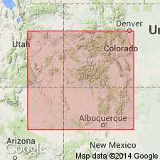
Summary:
Named as the upper member of Middle Jurassic Wanakah Formation of San Rafael Group for Horse Mesa, which extends from sec 17, T38N, R31E, Apache Co, AZ, Black Mesa basin to secs 26, 27, T29N, R21W, San Juan Co, NM, San Juan basin. Type section measured at this exposure. Name replaces use of Bluff Sandstone (lower sandstone or A unit of Bluff) in northwest NM. Recognized in parts of northeast AZ, northwest NM, and southeast UT (Paradox basin). Consists of red to orange, fine- to coarse-grained, well to moderately sorted, subangular to subround sandstone. Is wavy laminated with minor tabular, planar, and trough cross-beds. Has abundant black accessory minerals and abundant white chert. Thins northward. Is 36.5 ft thick at type. Southwards grades laterally into Cow Springs Sandstone. Grades eastward into Beclabito Member (called Bluff in older reports). Overlies Beclabito Member (new) of Wanakah. Underlies Salt Wash Member of Morrison Formation at type, and under Bluff Sandstone Member of Morrison in Apache Co, AZ. Probably correlates with lower unit of Junction Creek Sandstone of southwest CO. Deposited in eolian dune, interdune, and sabkha environments.
Source: GNU records (USGS DDS-6; Denver GNULEX).
- Usage in publication:
-
- Horse Mesa Member*
- Modifications:
-
- Areal extent
- AAPG geologic province:
-
- San Juan basin
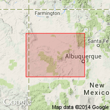
Summary:
Can be correlated from its type section throughout much of the San Juan basin, but it does not appear to extend as far south to connect with the Mesita Member (new) of the Wanakah in the southeast part of the basin. Because of the gap in exposures between Horse Mesa and Mesita, the Mesita is considered a separate unit rather than a southern extension of the Horse Mesa. Map showing southern limit.
Source: GNU records (USGS DDS-6; Denver GNULEX).
For more information, please contact Nancy Stamm, Geologic Names Committee Secretary.
Asterisk (*) indicates published by U.S. Geological Survey authors.
"No current usage" (†) implies that a name has been abandoned or has fallen into disuse. Former usage and, if known, replacement name given in parentheses ( ).
Slash (/) indicates name conflicts with nomenclatural guidelines (CSN, 1933; ACSN, 1961, 1970; NACSN, 1983, 2005, 2021). May be explained within brackets ([ ]).