The National Geologic Map Database is migrating to a new infrastructure. We apologize for any service disruptions during this process.
|
|---|


- Usage in publication:
-
- Hite Bed*
- Modifications:
-
- Revised
- AAPG geologic province:
-
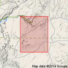
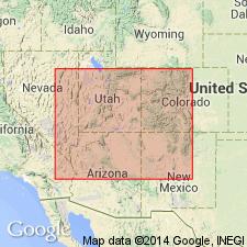
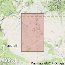
- Paradox basin
- Black Mesa basin
Summary:
Hite Bed is a sandstone at the top of the Upper Triassic Chinle Formation beneath the Wingate Sandstone and not assigned to a member of the Chinle in this report. Hite, along Comb Ridge south of Moses Rock, southeast UT in the Paradox basin to the UT-AZ State line, is split into an upper and lower part by reddish-orange siltstone designated division A by Gregory (1917) and Church Rock Member of Chinle by Witkind and Thaden (1963). The upper part consists of fine- to medium-grained, cross-bedded, pale-red, locally reddish-orange to brown sandstone, some brown siltstone or shale. The lower part, more heterogeneous than the upper part, consists of red-brown to greenish-gray, fine to very coarse grained, locally conglomeratic sandstone. The conglomerate has pebbles of limestone and sandstone 3-4 in across. Hite ranges from 30-60+ ft thick north of Moses Rock. To south of Moses Rock, lower part thins from 102 ft to 15 ft thick. Cross sections. Separated from underlying Owl Rock Member of Chinle by an unconformity. Numerous minor channeled erosional surfaces in Hite, none of which can be traced regionally. Of fluvial origin.
Source: GNU records (USGS DDS-6; Denver GNULEX).
- Usage in publication:
-
- Hite Bed*
- Modifications:
-
- Named
- Dominant lithology:
-
- Sandstone
- Conglomerate
- AAPG geologic province:
-
- Paradox basin
- Black Mesa basin
Summary:
Raised from informal status to formal status. Name retained as Hite Bed, upper bed of Church Rock Member of Chinle Formation. Type section designated as near Colorado River at the Horn and continuing up promontory to north. Promontory is 1.75 miles south-southeast of Hite, San Juan Co, UT in the Paradox basin. Is 34 ft thick at type where it overlies lower part of Church Rock and underlies Wingate Sandstone. Consists of: 1) pale-red to brown, fine- to medium-grained, well sorted, firmly cemented, calcareous to noncalcareous sandstone of subangular clear quartz, green and orange accessory minerals, white, fine-grained mica; and 2) red to red-brown (fresh), brown (weathered), poorly sorted, fine- to medium-grained conglomeratic sandstone to cobble conglomerate with abundant granules to cobbles. Is a widespread unit. Areal distribution map shows it as present in San Juan, Wayne, and Garfield Cos, UT, Paradox basin, and into Navajo and Apache Cos, AZ in the Black Mesa basin. Beds are trough cross-stratified. Northeast stream direction. Late Triassic age.
Source: GNU records (USGS DDS-6; Denver GNULEX).
- Usage in publication:
-
- Hite Bed*
- Modifications:
-
- Overview
- AAPG geologic province:
-
- Black Mesa basin
Summary:
A grayish-red to dusky-red, fine- to coarse-grained, medium- to thick-bedded, arkosic sandstone with minor mudstone is the uppermost bed of the Upper Triassic Church Rock Member of the Chinle Formation. The lower contact of the Hite with Church Rock is scoured. The upper contact is with the Wingate Sandstone (restricted to the eolian sandstone). The upper contact is marked by desiccation cracks that extend downward about 10 cm into the Hite. This same characteristic marks the Rock Point Member (reassigned to Chinle from the Wingate)-Wingate contact. Shown on cross section between Owl Rock and Comb Ridge, AZ in the Black Mesa basin. Pinches out east of Comb Ridge.
Source: GNU records (USGS DDS-6; Denver GNULEX).
For more information, please contact Nancy Stamm, Geologic Names Committee Secretary.
Asterisk (*) indicates published by U.S. Geological Survey authors.
"No current usage" (†) implies that a name has been abandoned or has fallen into disuse. Former usage and, if known, replacement name given in parentheses ( ).
Slash (/) indicates name conflicts with nomenclatural guidelines (CSN, 1933; ACSN, 1961, 1970; NACSN, 1983, 2005, 2021). May be explained within brackets ([ ]).