

- Usage in publication:
-
- Hell Creek beds
- Modifications:
-
- Original reference
- Dominant lithology:
-
- Sandstone
- Clay
- AAPG geologic province:
-
- Williston basin
Summary:
Pg. 829-835. Hell Creek beds. Fossil-bearing, fresh-water deposits of alternating sandstones and clays 560 feet thick in western half of Dawson County, Montana. Most constant member of series is massive sandstone at base, 0 to 160 feet thick. Probably continuous with the dinosaur-bearing beds of Little Missouri and Grand and Moreau Rivers, judging from fauna. These beds, with the underlying and overlying deposits, are typically exposed on Hell Creek [Garfield County] and nearby tributaries of Missouri River. Assigned to Upper Cretaceous. Separated from overlying Fort Union formation by 100 feet of lignite beds, here called Fort Union(?). Rests unconformably on Fox Hills formation. Lithologically similar in almost every respect to Ceratops beds of Converse County, Wyoming.
Source: US geologic names lexicon (USGS Bull. 896, p. 937-938).
- Usage in publication:
-
- Hell Creek member*
- Modifications:
-
- Revised
- AAPG geologic province:
-
- Williston basin
Summary:
Pg. 484-499. Hell Creek member of Lance formation as here defined is typically exposed on Hell Creek, Garfield County, Montana, and is = "HeII Creek beds" plus "lignite beds" of Brown (1907), occupying the interval between Fox Hills sandstone below and the yellow Tullock member of the Lance above. In southwestern North Dakota it is overlain by either Ludlow lignitic member of the Lance or the contemporaneous Cannonball marine member of the Lance, and it rests on Fox Hills sandstone. It consists of somber, badland clays, probably accumulated in topset swamps of a great delta, and fluviatile sandstones, the latter being more numerous and conspicuous toward southwest. Remains of a few small mammals have been found in the sandstones. Dinosaurs (including TRICERATOPS) are numerous below the "A" lignite, which marks base of Brown's "lignite beds," but probably have not been found above that horizon. [Mention other fossils.] Tbe Hell Creek and overlying strata are markedly calcareous in contrast with the brown member of the Fox Hills and older rocks, which are relatively free from lime. In Cedar Creek anticline, Montana, the Hell Creek member overlies Colgate sandstone member of Fox Hills sandstone; at mouth of Cannonball River, North Dakota, it rests on Fox Hills andstone. [Diagram on p. 484 shows no unconformity above or below Hell Creek member.]
Source: US geologic names lexicon (USGS Bull. 896, p. 937-938).

- Usage in publication:
-
- Hell Creek formation*
- Modifications:
-
- Revised
- Age modified
- AAPG geologic province:
-
- Central Montana uplift
- Montana folded belt
- Powder River basin
- Williston basin
Summary:
These rocks are now [ca. 1936] called Hell Creek formation by the USGS, and are classified as Upper Cretaceous, as explained under Lance formation, last entry [= GNC remark, ca. 1936, US geologic names lexicon, USGS Bull. 896, p. 1142].
Recognized in eastern, northern, and central southern MT, southwestern ND, and northwestern and northern SD.
Source: US geologic names lexicon (USGS Bull. 896, p. 937-938).
- Usage in publication:
-
- Hell Creek member
- Modifications:
-
- Revised
- AAPG geologic province:
-
- Williston basin
Summary:
Pg. 5 (fig.), 6 (table), 8-9, geol. map. Hell Creek member of Lance formation. Gray gumbo sands and clay with coal. Often called "somber sands." Thickness estimated between 85 and 312 feet. In Harding County, South Dakota, includes Bull Creek sand (new) below Heikkila coal. Underlies Ludlow member of Lance formation; overlies Fox Hills Formation. Fossils (vertebrates). Beds interpreted to represent swamp and coastal plain deposits. Age is Cretaceous.
Source: Publication; US geologic names lexicon (USGS Bull. 1200, p. 1724-1725).
- Usage in publication:
-
- Hell Creek formation
- Modifications:
-
- Biostratigraphic dating
- AAPG geologic province:
-
- Central Montana uplift
Summary:
Pg. 15 (table), 16-20. Hell Creek formation. For purposes of present report [Fort Union of Crazy Mountain field, Montana], it is assumed that beds up to and including the true dinosaur-bearing Lance and Hell Creek and their equivalents belong to the Cretaceous and that overlying beds without dinosaurs (except by redeposition) and with mammals of Tertiary type (including carnivores, condylarths, and others) from the Puerco and its equivalents upward, are to be placed in the Tertiary. It is also assumed that Paleocene is accepted as separate epoch. Hell Creek formation underlies Bear formation (new).
Source: US geologic names lexicon (USGS Bull. 1200, p. 1724-1725).
- Usage in publication:
-
- Hell Creek member
- Modifications:
-
- Mapped
- AAPG geologic province:
-
- Williston basin
Summary:
Pg. 10-11, pls. 1, 3. Hell Creek member of Lance formation. In McCone County, Montana, Hell Creek beds, mapped as member of Lance formation, overlie Colgate sandstone member of Fox Hills formation and underlie Tullock member of Lance. Thickness about 135 feet. Footnote (p. 10) states that since the present report was written, Hell Creek and Tullock members have been raised to rank of formations in official classification of the U.S. Geological Survey; Hell Creek is assigned to the Cretaceous and the Tullock to Cretaceous or Eocene. Lance of the present report is placed in Eocene(?).
Source: US geologic names lexicon (USGS Bull. 1200, p. 1724-1725).
- Usage in publication:
-
- Hell Creek formation
- Modifications:
-
- Biostratigraphic dating
- Age modified
- AAPG geologic province:
-
- Powder River basin
Dorf, Erling, 1940, Relationship between floras of type Lance and Fort Union formations: Geological Society of America Bulletin, v. 51, no. 2, p. 213-235.
Summary:
Pg. 213-236. Discussion of relationship between floras of type Lance and Fort Union formations. Lance formation (equivalent to Hell Creek formation) is placed in Upper Cretaceous; Tullock formation (equivalent to Ludlow formation and Cannonball marine member) is placed at base of Paleocene Fort Union group.
Source: US geologic names lexicon (USGS Bull. 1200, p. 1724-1725).
- Usage in publication:
-
- Hell Creek formation
- Modifications:
-
- Revised
- AAPG geologic province:
-
- Williston basin
Summary:
Pg. 9-15. Hell Creek formation. Described in Morton County, North Dakota, where it is about 250 feet thick in complete exposures. Includes Breien member (new). Overlies Fox Hills formation; underlies Ludlow formation of Fort Union group. Age is Late Cretaceous.
Source: Publication; US geologic names lexicon (USGS Bull. 1200, p. 1724-1725).
- Usage in publication:
-
- Hell Creek formation
- Modifications:
-
- Overview
- AAPG geologic province:
-
- Williston basin
Seager, O.A., Ballard, W.N., Blackstone, D.L., Jr., Cobban, W.A., and Downs, G.R., 1942, Discussion; Stratigraphy of North Dakota: American Association of Petroleum Geologists Bulletin, v. 26, no. 8, p. 1414-1423.
Summary:
Pg. 1415, 1418. Hell Creek formation. Youngest Cretaceous formation known in North Dakota. Consists largely of gray bentonitic sands and shales with which are lenticular beds of lavender-brown lignitic shale and rusty-brown to purplish-black ferruginous concretions. Thickness varies from 575 feet near Marmarth to less than 100 feet in Souris River area. Underlies Cannonball member-Ludlow member of Fort Union. Fossils. Age is Late Cretaceous.
Source: US geologic names lexicon (USGS Bull. 1200, p. 1724-1725).
- Usage in publication:
-
- Hell Creek formation*
- Modifications:
-
- Areal extent
- AAPG geologic province:
-
- Denver basin
Summary:
Pg. 81. Laramie formation (redefined) is equivalent to the Lance, and thus becomes equivalent to the Hell Creek.
Source: US geologic names lexicon (USGS Bull. 1200, p. 1724-1725).
- Usage in publication:
-
- Hell Creek formation*
- Modifications:
-
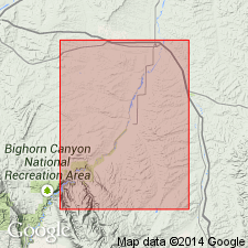
- Mapped 1:63k (Big Horn Co, MT)
- Dominant lithology:
-
- Sandstone
- AAPG geologic province:
-
- Powder River basin
Summary:
Mapped in northeasternmost corner of study area Big Horn Co, MT, northwestern Powder River basin. Only lower few feet is exposed. Consists of sandstone which supports growth of pine trees. Assigned to Montana group. Overlies Bearpaw shale; youngest Cretaceous rocks in study area. Late Cretaceous age.
Source: GNU records (USGS DDS-6; Denver GNULEX).
- Usage in publication:
-
- Hell Creek formation
- Modifications:
-
- Mapped
- AAPG geologic province:
-
- Williston basin
Summary:
See also R.E. Curtiss, 1954, Areal geology of the Firesteel Creek quadrangle (1:62,500), South Dakota Geol. Survey.
Hell Creek formation. Overlies Colgate sandstone member of Fox Hills. Thickness about 230 feet. Contains Isabel-Firesteel coal member [facies], 0 to 6 feet thick. Age is Late Cretaceous.
Source: US geologic names lexicon (USGS Bull. 1200, p. 1724-1725).
- Usage in publication:
-
- Hell Creek formation
- Modifications:
-
- Areal extent
- AAPG geologic province:
-
- Williston basin
Summary:
Pg. 17-20. Hell Creek formation. Described in Emmons County where it is about 270 feet thick. Overlies Fox Hills formation and underlies Cannonball formation. Fossils. Age is Late Cretaceous.
Source: US geologic names lexicon (USGS Bull. 1200, p. 1724-1725).
- Usage in publication:
-
- Hell Creek formation
- Modifications:
-
- Areal extent
- AAPG geologic province:
-
- Powder River basin
Summary:
Hell Creek formation. Mapped in northeastern Wyoming. Consists of brown and gray sandstone and shale, thin coal, and carbonaceous shale beds. [Age is Late Cretaceous.]
Source: US geologic names lexicon (USGS Bull. 1200, p. 1724-1725).
- Usage in publication:
-
- Hell Creek formation
- Modifications:
-
- Areal extent
- AAPG geologic province:
-
- Montana folded belt
Summary:
Pl. 7. Plate 7 shows that Livingston formation intertongues with Claggett, Judith River, Bearpaw, Lennep, Hell Creek, Tullock, and Lebo formations.
Source: US geologic names lexicon (USGS Bull. 1200, p. 1724-1725).
- Usage in publication:
-
- Hell Creek formation
- Modifications:
-
- Mapped
- AAPG geologic province:
-
- Williston basin
Summary:
Hell Creek formation. Comprises a lower unit about 60 feet thick, at top of which is Isabel-Firesteel facies, and upper unit about 80 feet thick. Interfingers with overlying Ludlow formation; overlies Colgate member of Fox Hills formation. Age is Late Cretaceous.
Source: US geologic names lexicon (USGS Bull. 1200, p. 1724-1725).
- Usage in publication:
-
- Hell Creek Formation*
- Modifications:
-
- Revised
- AAPG geologic province:
-
- Central Montana uplift
- Montana folded belt
- Powder River basin
- Williston basin
Summary:
Hell Creek Formation included as uppermost unit of Montana Group because of its lithogenetic similarities to underlying Cretaceous units; Miner Creek and St. Mary River Formations, Hell Creek equivalents, are not included within Montana. Study area is within central MT in Lewis and Clark and Meagher Cos (Montana folded belt province), Wheatland, Golden Valley, and Fergus Cos (Central Montana uplift), Garfield Co (Williston basin), and Bighorn Co (Powder River basin). Cross sections; ammonite zones on cross sections; table of stratigraphic nomenclature for MT and WY. Early and late Maestrichtian (Late Cretaceous) age.
Source: GNU records (USGS DDS-6; Denver GNULEX).
- Usage in publication:
-
- Hell Creek Formation
- Modifications:
-
- Areal extent
- AAPG geologic province:
-
- Williston basin
Summary:
Basal contact with Fox Hills Sandstone is time-transgressive eastward. Contact placed at base of mudstones and muddy sandstone above ledge-forming clean sandstone (Fox Hills). Upper contact revised in that Hell Creek underlies the newly named Nelson Ranch Member of Tullock Formation [of Fort Union Group]; Hell Creek-Nelson Ranch contact placed at base of upper Z-coal. Regionally the Z-coal has actually as many as 7 distinct coals. The upper Z-coal lies 2-6 m above the K/T boundary. Widespread unit. Geologic map. Columnar section. Measured sections. Forms badlands. Consists of lenticularly interbedded somber-colored sandstones of various origins (floodplain, channel fill, splay), green and purple siltstone, variegated siderite-bearing siltstone, and coal. Clay-pebble conglomerates present in many channel fills. The sandstones are subangular to subround, medium- to well-sorted, have high clay content, admixtures of dark chert and ferromagnesium minerals. The sandstones occurs as lenses, in wide braided-appearing or as extensive thin sheets. The formation accumulated along borders of rivers. Has the youngest Cretaceous and oldest Paleocene rocks. Ranges from 51 m thin in south part of report area to 70 m thick in central and northeast part of area, McCone Co, MT in the Williston basin.
Source: GNU records (USGS DDS-6; Denver GNULEX).
- Usage in publication:
-
- Hell Creek Formation*
- Modifications:
-
- Age modified
- AAPG geologic province:
-
- Central Montana uplift
Summary:
The uppermost part of the Hell Creek Formation at East Burnt Creek, SE1/4 SW1/4 SW1/4 sec 36, T4N, R35E, Treasure Co, MT on the Central Montana uplift, is earliest Paleocene age if the base of the overlying Tullock Member of the Fort Union Formation is placed at the base of the lowest persistent coal bed called coal bed A by Rogers and Lee (1923). The coal at that locality is about 3 m above the K-T boundary. However, if the Hell Creek-Tullock contact were placed in this area at the color change from gray (Hell Creek) to buff (Tullock) rather than at the base of the persistent coal, the Tullock would be partly Late Cretaceous age. These authors use the base of the persistent coal as the basal contact of the Tullock. The age of the Hell Creek at East Burnt Creek is modified to Late Cretaceous and earliest Paleocene.
Source: GNU records (USGS DDS-6; Denver GNULEX).

- Usage in publication:
-
- Hell Creek Formation*
- Modifications:
-
- Areal extent
- AAPG geologic province:
-
- Powder River basin
Summary:
Identified in the subsurface of the Powder River basin, MT, where it overlies Fox Hills Sandstone. Is equivalent to the Lance Formation which also overlies Fox Hills in WY. Of Late Cretaceous age. [This nomenclature shown on 22 cross sections in this OC series.]
Source: GNU records (USGS DDS-6; Denver GNULEX).
- Usage in publication:
-
- Hell Creek Formation
- Modifications:
-
- Principal reference
- AAPG geologic province:
-
- Williston basin
Summary:
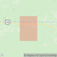
Hell Creek Formation. Consists of (descending): upper mudstone sequence, Apex sandstone, middle mudstone sequence, JenRex sandstone, lower mudstone sequence, and basal sandstone. Thickness about 276 feet (84.2 m). Overlies Fox Hills Formation; underlies Tullock Member of Fort Union Formation.
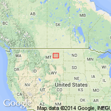
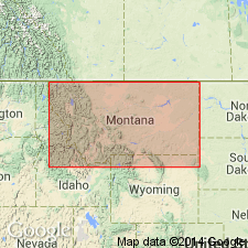
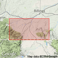
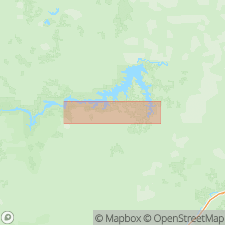
Lectostratotype (composite): in Ried Coulee and East Ried Coulee, in N/2 sec. 29, T. 21 N., R. 38 W., from about Lat. 47.55122 deg. N., Long. 106.86217 deg. W., northwestward to Lat. 47.56908 deg. N., Long. 106.89648 deg. W., Maloney Hill and Buffalo Hill quadrangles, Garfield Co., eastern MT.
Source: Publication.
For more information, please contact Nancy Stamm, Geologic Names Committee Secretary.
Asterisk (*) indicates published by U.S. Geological Survey authors.
"No current usage" (†) implies that a name has been abandoned or has fallen into disuse. Former usage and, if known, replacement name given in parentheses ( ).
Slash (/) indicates name conflicts with nomenclatural guidelines (CSN, 1933; ACSN, 1961, 1970; NACSN, 1983, 2005, 2021). May be explained within brackets ([ ]).