

- Usage in publication:
-
- Groat sandstone bed*
- Modifications:
-
- Original reference
- Dominant lithology:
-
- Sandstone
- Siltstone
- AAPG geologic province:
-
- Williston basin
Summary:
Groat sandstone bed. Ferruginous and glauconitic sandstone and siltstone, 150 feet thick in northern part of area. Lies near top of Gammon ferruginous member of Pierre shale. Age is Late Cretaceous.
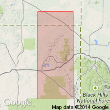
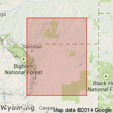
Named from exposures along Groat Creek, in T. 7 S., R. 56 E., Carter Co., southeastern MT. [Extends into northeastern WY.]
Source: US geologic names lexicon (USGS Bull. 896, p. 883).
- Usage in publication:
-
- Groat sandstone bed*
- Modifications:
-
- Age modified
- AAPG geologic province:
-
- Powder River basin
Summary:
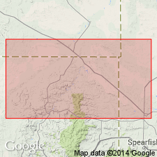
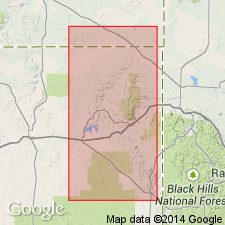
Is a bed in the Gammon ferruginous member of Pierre shale on western rim of the Black Hills, WY in Powder River basin. Late Cretaceous in age. Age refined as Campanian.
Source: GNU records (USGS DDS-6; Denver GNULEX).
- Usage in publication:
-
- Groat sandstone bed*
- Modifications:
-
- Areal extent
- AAPG geologic province:
-
- Powder River basin
- Williston basin
Summary:
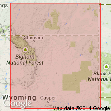
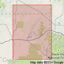
A bed in the Gammon ferruginous member of Pierre shale. Map shows distribution on the north side of the Black Hills, in parts of Crook Co, WY and Butte Co, SD in Powder River and Williston basins. Late Cretaceous in age.
Source: GNU records (USGS DDS-6; Denver GNULEX).
- Usage in publication:
-
- Groat sandstone bed*
- Modifications:
-
- Biostratigraphic dating
- AAPG geologic province:
-
- Powder River basin
- Williston basin
Summary:
A bed in the Gammon ferruginous member of Pierre shale. Lists index fossils and discusses their stratigraphic and geographic distribution in Powder River basin and southernmost part of Williston basin. Shows faunal zonation. Late Cretaceous (early Campanian) in age.
Source: GNU records (USGS DDS-6; Denver GNULEX).
- Usage in publication:
-
- Groat sandstone
- Modifications:
-
- Revised
- AAPG geologic province:
-
- Powder River basin
Summary:
Is considered a member [although author uses only Groat sandstone] of Eagle formation in northeast part of Powder River basin, WY. Overlain by the upper Gammon unit [of Eagle formation]; underlain by the lower Gammon unit (Telegraph Creek formation). Correlated with Shannon member of Eagle formation in other parts of Powder River basin. Late Cretaceous in age.
Source: GNU records (USGS DDS-6; Denver GNULEX).
- Usage in publication:
-
- Groat sandstone bed*
- Modifications:
-
- Biostratigraphic dating
- AAPG geologic province:
-
- Williston basin
- Powder River basin
Summary:
Bed in the Gammon ferruginous member of Pierre shale. Gives description and lists fossils in Carter Co, MT and northern part of Crook Co, WY in Williston and Powder River basins. Not present in southern part of Crook Co and Weston Co, WY. Thickness is 81 ft, and 73 ft in sections measured in sec 4, T9S, R56E, Carter Co, MT and in sec 17, T9S, R62E, Carter Co, MT, respectively. Late Cretaceous (early Campanian) in age.
Source: GNU records (USGS DDS-6; Denver GNULEX).
- Usage in publication:
-
- Groat sandstone bed*
- Modifications:
-
- Areal extent
- AAPG geologic province:
-
- Williston basin
- Powder River basin
Summary:
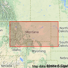
A bed in the upper part of Gammon ferruginous member of Pierre shale. Shows distribution of outcrops in northwestern part of Black Hills, WY, MT, and SD in Powder River and Williston basins. Describes general and local features, including fossil content. Late Cretaceous (Campanian) in age.
Source: GNU records (USGS DDS-6; Denver GNULEX).
- Usage in publication:
-
- Groat Sandstone Bed*
- Modifications:
-
- Areal extent
- AAPG geologic province:
-
- Williston basin
Summary:
Is a sandstone that crops out 45 m below the top of the Gammon Ferruginous Member of the Pierre Shale along the northern flank of the Black Hills in SD and MT. Is not widely used and is hereby restricted to the outcrop shown on fig. 23 in the Williston basin. The name Shannon Sandstone Member is thus extended from WY to the subsurface of east-central MT and northwestern SD as a member of the Gammon Shale (raised to rank of formation) and applied to sandstone equivalent to the Groat in the subsurface. The sandstone in the subsurface of MT and SD correlates with the type Shannon of WY. Age is given as Campanian (Late Cretaceous).
Source: GNU records (USGS DDS-6; Denver GNULEX).
For more information, please contact Nancy Stamm, Geologic Names Committee Secretary.
Asterisk (*) indicates published by U.S. Geological Survey authors.
"No current usage" (†) implies that a name has been abandoned or has fallen into disuse. Former usage and, if known, replacement name given in parentheses ( ).
Slash (/) indicates name conflicts with nomenclatural guidelines (CSN, 1933; ACSN, 1961, 1970; NACSN, 1983, 2005, 2021). May be explained within brackets ([ ]).