

- Usage in publication:
-
- Gilman sandstone member
- Modifications:
-
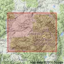
- Areal extent
- AAPG geologic province:
-
- Eagle basin
Tweto, Ogden, and Lovering, T.S., 1947, The Gilman district, Eagle County, [Colorado]: Colorado Mineral Resources Board [Bulletin], p. 378-387., (Part 2 prepared by the U.S. Geological Survey, under the general supervision of W.S. Burbank.)
Summary:
Pg. 380 (chart of geologic formations in Gilman district). Gilman sandstone member of Leadville limestone. Gray sandstone, black cherty dolomite, and breccia containing much black clay. Breccia related both to Paleozoic weathering and to mineralization during the Laramide [orogeny]. Thickness 20 to 50 feet. At base of Leadville limestone. Age is Mississippian.
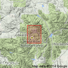
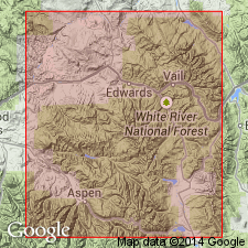
[Recognized in Gilman district, Eagle Co., west-central CO.]
Source: Publication; US geologic names lexicon (USGS Bull. 1200, p. 1509-1510).
- Usage in publication:
-
- Gilman sandstone member*
- Modifications:
-
- Principal reference
- Dominant lithology:
-
- Sandstone
- Dolomite
- AAPG geologic province:
-
- Eagle basin
Summary:
Pg. 152 (table 1), 177-184. Gilman sandstone member of Leadville limestone (or dolomite). Re-proposed for sandstone and associated breccia at base of Leadville limestone (or dolomite). Consists of lenticular beds of sandstone, dolomitic sandstone, or local quartzite, at base, overlain by sandy and locally cherty dolomite which at most places is interbedded with and overlain by breccia of dolomite and chert; sandstone is yellow, buff, or light-gray, medium- to coarse-grained, and slightly arkosic; individual sandstone beds 2 to 24 inches thick; sandy dolomite is dense, dark, and weathers light; typically brecciated and contains chert in fragments, nodules, and lenticles. Thickness commonly 10 to 20 feet; range from 5 to 50 feet observed. Underlies massive gray dolomite member; in most places, contact is a few feet of fine-grained structureless soft dark-brownish-gray dolomite; separated from underlying Chaffee formation (Dyer dolomite member); by unconformity. Age is Early Mississippian.
Named from exposures on cliffs of Eagle Canyon, at Gilman, Pando area, [Minturn 7.5-min quadrangle], Eagle Co., west-central CO.
Source: US geologic names lexicon (USGS Bull. 1200, p. 1509-1510).
- Usage in publication:
-
- Gilman Limestone Member*
- Modifications:
-
- Age modified
- AAPG geologic province:
-
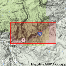
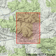
- Eagle basin
- Piceance basin
Summary:
Age modified from Mississippian to probably Kinderhook and Osage, or Early Mississippian. Is present as the basal member of the Leadville Limestone at east end of Glenwood Canyon near the Garfield-Eagle Co line, CO in the Eagle and Piceance basins. Meramec and Osage endothyrid faunas found in lower part of upper part of Leadville 50 ft above top of Gilman.
Source: GNU records (USGS DDS-6; Denver GNULEX).
- Usage in publication:
-
- Gilman Sandstone Member*
- Modifications:
-
- Overview
- AAPG geologic province:
-
- Eagle basin
- Piceance basin
Summary:
The lowest 20 to 30 ft of Leadville Limestone is a very sandy dolomite that is finely crystalline, gray, thought to be equivalent to the Gilman Sandstone Member of Leadville. This unit is useful for recognizing the Chaffee-Leadville contact. Overlain by unnamed gray limestone typical of Leadville. Section 19 ft 8 in thick measured in S1/2 sec 11, T5S, R87W in Garfield Co just west of the Eagle Co line. Leadville mapped on geologic map as an undivided unit in Garfield and Rio Blanco Cos in the Piceance basin, and in Eagle Co in the Eagle basin. [Areal extent not clearly stated.] Mississippian age.
Source: GNU records (USGS DDS-6; Denver GNULEX).
- Usage in publication:
-
- Gilman Member
- Modifications:
-
- Areal extent
- AAPG geologic province:
-
- Eagle basin
Summary:
Gilman Member of Leadville Limestone. Arenaceous micrite, orthoquartzites, dolomicrites, limestone-pebble conglomerates, and breccias. Thickness 14 to 38 feet. Recognized in Eagle, Lake, and Pitkin Counties, Colorado. Unconformably overlies Dyer Formation and unconformably underies Redcliff member (informal) of Leadville. Age is Early Mississippian (Kinderhookian).
Source: Modified from GNU records (USGS DDS-6; Denver GNULEX).
- Usage in publication:
-
- Gilman Sandstone*
- Modifications:
-
- Revised
- AAPG geologic province:
-
- Eagle basin
Summary:
Removed from Leadville Limestone as its basal member and reassigned to Chaffee Group as its uppermost formation. Overlies Dyer Dolomite of Chaffee unconformably. Underlies Leadville Limestone (Dolomite in the mining area) unconformably. Mapped (geologic map) with Dyer and underlying Parting Formation of Chaffee Group southeast of Minturn, southeast part of quad, Eagle Co, in Eagle basin. Is typically a thin but persistent sandstone about 20 ft thick, but ranges from 10 to 50 ft thick. Consists of sandstone, breccia, and dolomite. The major lithology is yellow to gray, well-sorted sandstone of rounded quartz grains cemented by dolomite, calcite, and silica. The dolomite is gray, fine grained, finely laminated. The basal bed of sandstone is usually overlain by a few ft of interbedded sandstone and dolomite in beds that pinch at swell, overlain by lenticular bodies of breccia, dolomite, and sandstone. Top marked by the waxy bed, a gray lithographic dolomite, at many places. Chert abundant locally. Shallow water deposit. Unfossiliferous. May be Late Devonian or Early Mississippian.
Source: GNU records (USGS DDS-6; Denver GNULEX).
- Usage in publication:
-
- Gilman Sandstone
- Modifications:
-
- Revised
- AAPG geologic province:
-
- Eagle basin
Summary:
Top formation of Chaffee Group, Gilman Sandstone, restricted. The uppermost 15+ feet of dolomite previously assigned to the Gilman by Tweto and Lovering (1977, = their beds 6, 7, and 8) are transferred to overlying Red Cliff Member of Leadville Dolomite. Gilman (restricted) separated from the Red Cliff by M-1 unconformity. [Age is considered Late Devonian and Mississippian.]
Described from Leadville mining district, Lake Co., west-central CO.
Source: Modified from GNU records (USGS DDS-6; Denver GNULEX).
For more information, please contact Nancy Stamm, Geologic Names Committee Secretary.
Asterisk (*) indicates published by U.S. Geological Survey authors.
"No current usage" (†) implies that a name has been abandoned or has fallen into disuse. Former usage and, if known, replacement name given in parentheses ( ).
Slash (/) indicates name conflicts with nomenclatural guidelines (CSN, 1933; ACSN, 1961, 1970; NACSN, 1983, 2005, 2021). May be explained within brackets ([ ]).