The National Geologic Map Database is migrating to a new infrastructure. We apologize for any service disruptions during this process.
|
|---|


- Usage in publication:
-
- Geertsen Canyon Quartzite*
- Modifications:
-
- Named
- Dominant lithology:
-
- Quartzite
- AAPG geologic province:
-
- Wasatch uplift
- Northern Rocky Mountain region
Summary:
Pg. 592-593. Geertsen Canyon Quartzite. Name proposed for the upper formation of Brigham Group in the Hunstville area, Weber County, northern Utah. Rocks formerly called Brigham Quartzite (restricted). Divided into two unnamed members. Lower member consists of a very coarse-grained arkose containing fragments of salmon-colored microcline and pale-greenish plagioclase as much as a half-inch in diameter, thickness 300 to 400 feet; and an overlying tan- to white-weathering quartzite, thickness 800 feet. Upper member consists of pale-buff to white or pale-pink, generally coarse-grained, conglomeratic quartzite with pebbles as much as an inch in diameter, thickness about 3,000 feet. Total thickness at type section 1,340 m [approx. 4,400 feet]. Thought to correlate with: Camelback Mountain Quartzite (new) of Pocatello area, southeastern Idaho; Prospect Mountain Quartzite of Beaver Mountains; and Tintic Quartzite of central Utah. Conformably overlies Browns Hole Formation (new) of Brigham Group; conformably underlies Langston Dolomite. Age is Precambrian and Early(?) Cambrian. (Geertsen Canyon Quartzite adopted by the USGS as uppermost formation in Brigham Group.)
GNU records (USGS DDS-6; Denver GNULEX) state Geertsen Canyon Quartzite lies in the Precambrian Northern Rocky Mountain region and in the Phanerozoic Wasatch uplift province.
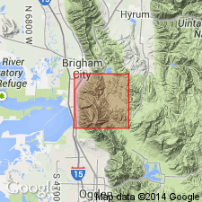
Type section: exposures on ridge west of Geertsen Canyon, 8 km [approx. 5 mi] north of Huntsville, in secs. 18 and 19, T. 17 N., R. 2 E., Weber Co., UT. Named from Geertsen Canyon.
[Misprint: US geologic names lexicon (USGS Bull. 1520, p. 111) states formation is Early Cambrian age. Formation is Precambrian and Early(?) Cambrian age.]
Source: Changes in stratigraphic nomenclature, 1971 (USGS Bull. 1372-A, p. A8-A9); GNU records (USGS DDS-6; Denver GNULEX, Menlo GNULEX); US geologic names lexicon (USGS Bull. 1520, p. 111).
- Usage in publication:
-
- Geertsen Canyon Quartzite*
- Modifications:
-
- Age modified
- AAPG geologic province:
-
- Wasatch uplift
- Great Basin province
Summary:
Age changed from late Precambrian and Early? Cambrian to Early Cambrian. Age change based on determination of age of volcanic rocks in underlying formation as very latest Precambrian. Report area lies on the Wasatch uplift and in the Great Basin province.
Source: GNU records (USGS DDS-6; Denver GNULEX).
For more information, please contact Nancy Stamm, Geologic Names Committee Secretary.
Asterisk (*) indicates published by U.S. Geological Survey authors.
"No current usage" (†) implies that a name has been abandoned or has fallen into disuse. Former usage and, if known, replacement name given in parentheses ( ).
Slash (/) indicates name conflicts with nomenclatural guidelines (CSN, 1933; ACSN, 1961, 1970; NACSN, 1983, 2005, 2021). May be explained within brackets ([ ]).