The National Geologic Map Database is migrating to a new infrastructure. We apologize for any service disruptions during this process.
|
|---|


- Usage in publication:
-
- Fork Ridge sandstone* member
- Modifications:
-
- Original reference
- Dominant lithology:
-
- Sandstone
- AAPG geologic province:
-
- Appalachian basin
Summary:
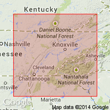
Pg. 31, 33, 39, 40. Fork Ridge sandstone member of Mingo formation of Pottsville group. Cliff-making sandstone in Mingo formation, lying about 40 feet below Mingo coal. Thickness few feet to 50 feet. Age is Pennsylvanian.
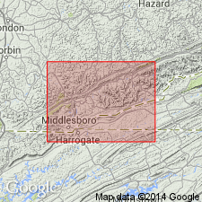
[Named from Fork Ridge, Bell Co., southeastern KY. Extends into northeastern TN.]
Source: US geologic names lexicon (USGS Bull. 896, p. 754).
- Usage in publication:
-
- Fork Ridge Sandstone Member*
- Modifications:
-
- Areal extent
- AAPG geologic province:
-
- Appalachian basin
Summary:
Pg. 82, 83, 89, 140. Fork Ridge Sandstone Member of Mingo formation. In Mingo formation above 40 feet below Mingo coal. Recognized in southeastern Kentucky and northeastern Tennessee. Age is Pennsylvanian.
Source: US geologic names lexicon (USGS Bull. 1200, p. 1389).
For more information, please contact Nancy Stamm, Geologic Names Committee Secretary.
Asterisk (*) indicates published by U.S. Geological Survey authors.
"No current usage" (†) implies that a name has been abandoned or has fallen into disuse. Former usage and, if known, replacement name given in parentheses ( ).
Slash (/) indicates name conflicts with nomenclatural guidelines (CSN, 1933; ACSN, 1961, 1970; NACSN, 1983, 2005, 2021). May be explained within brackets ([ ]).