The National Geologic Map Database is migrating to a new infrastructure. We apologize for any service disruptions during this process.
|
|---|


- Usage in publication:
-
- Emerald dolomite member*
- Modifications:
-
- Original reference
- Dominant lithology:
-
- Dolomite
- AAPG geologic province:
-
- Great Basin province
- South Western Overthrust
Summary:
Emerald dolomite member of Ajax limestone. Cream white, almost pure dolomite, for most part fine-grained but containing small patches and veinlets of coarser grain. Thickness 30 to 40 feet. Lies 90+/- feet above base of Ajax limestone. Age is Early Ordovician.
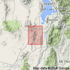
Named from Emerald Mine, [in northeast corner sec. 25, T. 10 S., R. 3 W., Eureka 7.5-min quadrangle, Lat. 39 deg. 55 min. 55 sec. N., Long. 112 deg. 07 min. 09 sec. W., Juab Co., central northern UT]. Continuously exposed from Mammoth to Eureka, Tintic district, central northern UT.
[Additional locality information from USGS GNIS database and USGS historical topographic map collection TopoView; accessed Leap Year Day February 29, 2016.]
Source: US geologic names lexicon (USGS Bull. 896, p. 684).

- Usage in publication:
-
- Emerald member*
- Modifications:
-
- Age modified
- Overview
- AAPG geologic province:
-
- Great Basin province
Summary:
Is a middle member of the Ajax dolomite that lies about 180 ft above base of formation. Section 29 ft thick measured at the type locality north of the Emerald mine in SE1/4 SE1/4 sec 24, T10S, R3W, Juab Co, UT in the Great Basin province. Conformably overlies lower member and underlies upper member at type where member is composed of white, even-grained, finely granular dolomite. Age changed from Early Ordovician or Late Cambrian to Late Cambrian on basis of presence of silicified brachiopods 30 ft below base of member. Correlation diagrams.
Source: GNU records (USGS DDS-6; Denver GNULEX).
For more information, please contact Nancy Stamm, Geologic Names Committee Secretary.
Asterisk (*) indicates published by U.S. Geological Survey authors.
"No current usage" (†) implies that a name has been abandoned or has fallen into disuse. Former usage and, if known, replacement name given in parentheses ( ).
Slash (/) indicates name conflicts with nomenclatural guidelines (CSN, 1933; ACSN, 1961, 1970; NACSN, 1983, 2005, 2021). May be explained within brackets ([ ]).