

- Usage in publication:
-
- Eldridge Creek Member*
- Modifications:
-
- Named
- Dominant lithology:
-
- Sandstone
- AAPG geologic province:
-
- Montana folded belt
Summary:
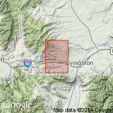
Named as the middle member of Cody Shale for exposures near Eldridge Creek in NE1/4 sec 27, T2S, R8E, Park Co, MT, Montana folded belt province. No type locality designated. Is a thin-bedded glauconitic sandstone that is 120 ft thick near its type section [on Eldridge Creek?]. Overlies lower shale member of Cody. Underlies upper shale member of Cody. Has a middle Niobrara fauna. Assigned to Late Cretaceous.
Source: GNU records (USGS DDS-6; Denver GNULEX).
- Usage in publication:
-
- Eldridge Creek Member*
- Modifications:
-
- Overview
- AAPG geologic province:
-
- Montana folded belt
Summary:
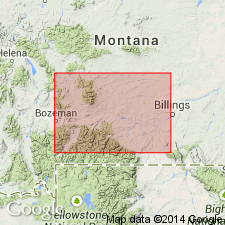
[Includes some information missing from naming paper.] Is a persistent thin-bedded, greenish-gray, fine-grained sandstone 90 to 120 ft thick that forms an excellent marker in the Cody Shale near Livingston, Park Co, MT, Montana folded belt province. Contains a shallow-water marine Niobrara fauna. Assigned to the late Coniacian, Late Cretaceous. Correlation chart.
Source: GNU records (USGS DDS-6; Denver GNULEX).
- Usage in publication:
-
- Eldridge Creek Sandstone Member*
- Modifications:
-
- Overview
- AAPG geologic province:
-
- Montana folded belt
Summary:
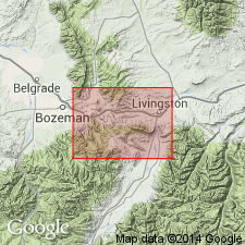
Eldridge Creek Sandstone Member, middle member of Cody Shale. Described from composite measured section: (1) outcrop on north side of Canyon Mountain, in sec. 27, T. 2 S., R. 9 E.; (2) subsurface Deerfield Oil Corp. Strong No. 1 well, in sec. 11, T. 2 S., R. 9 E., Park County, Montana. Consists of platy to thin-bedded, very fine-grained, silty, calcareous, very glauconitic, micaceous, pyritic, greenish-gray sandstone with thin interbeds of calcareous siltstone and silty, calcareous, brownish-gray shale. Thickness 120 feet. Separated from underlying Frontier Formation by lower shale member of Cody, and from overlying Telegraph Creek Formation by upper shale member of Cody. Is a shallow-water marine sandstone. Contains fossils (pelecypods, gastropods, cephalopods). Age is Late Cretaceous (Coniacian). Report includes geologic map, correlation chart, fossil list.
Source: Modified from GNU records (USGS DDS-6; Denver GNULEX).
For more information, please contact Nancy Stamm, Geologic Names Committee Secretary.
Asterisk (*) indicates published by U.S. Geological Survey authors.
"No current usage" (†) implies that a name has been abandoned or has fallen into disuse. Former usage and, if known, replacement name given in parentheses ( ).
Slash (/) indicates name conflicts with nomenclatural guidelines (CSN, 1933; ACSN, 1961, 1970; NACSN, 1983, 2005, 2021). May be explained within brackets ([ ]).