

- Usage in publication:
-
- Dillon Mesa Tuff*
- Modifications:
-
- Named
- Dominant lithology:
-
- Tuff
- AAPG geologic province:
-
- Piceance basin
Summary:
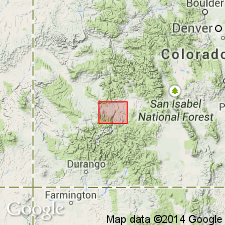
Named for exposures on Dillon Mesa, its type locality, in northern part of Sapinero and Cebolla quads, Gunnison Co, CO in Piceance basin. These rocks were assigned by Larsen and Cross (1956) to the lower member of Alboroto Rhyolite of Potosi Volcanic Series. Consists of light-brown, slightly porphyritic, moderately welded tuff. Includes a gravel at base. Usually is less than 80 ft thick but may be as much as 180 ft thick. Pinches out just west of Blue Mesa, south of Blue Mesa dam, Gunnison Co, CO. Overlies Blue Mesa Tuff (a new name); underlies Sapinero Mesa Tuff (a new name). Is of late Oligocene age.
Source: GNU records (USGS DDS-6; Denver GNULEX).
- Usage in publication:
-
- Dillon Mesa Tuff*
- Modifications:
-
- Areal extent
- AAPG geologic province:
-
- San Juan Mountains province
Summary:
Replaces in part name Gilpin Peak Tuff (Abandoned) in the San Juan Mountain province. Thought to be an early eruption from the Uncompahgre caldera in Oligocene time. Had an estimated initial volume of 50-100 cubic km and a reverse magnetic polarity.
Source: GNU records (USGS DDS-6; Denver GNULEX).
- Usage in publication:
-
- Dillon Mesa Tuff*
- Modifications:
-
- Areal extent
- Overview
- AAPG geologic province:
-
- Piceance basin
- San Juan Mountains province
Summary:
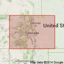
Areal extent of Dillon Mesa Tuff in southwestern Colorado shown on distribution map; present in San Juan and Ouray Counties (San Juan Mountain province), and in Gunnison County (Piceance basin). Had an estimated volume of 25 to 100 cubic km. Rhyolite in composition. Source caldera is probably the Uncompahgre. Age ranges from greater than 27.8 to less than 28.4 m.y.
Source: Modified from GNU records (USGS DDS-6; Denver GNULEX).
For more information, please contact Nancy Stamm, Geologic Names Committee Secretary.
Asterisk (*) indicates published by U.S. Geological Survey authors.
"No current usage" (†) implies that a name has been abandoned or has fallen into disuse. Former usage and, if known, replacement name given in parentheses ( ).
Slash (/) indicates name conflicts with nomenclatural guidelines (CSN, 1933; ACSN, 1961, 1970; NACSN, 1983, 2005, 2021). May be explained within brackets ([ ]).