

- Usage in publication:
-
- Delle Phosphatic Member*
- Modifications:
-
- Named
- Reference
- Dominant lithology:
-
- Claystone
- Mudstone
- AAPG geologic province:
-
- Great Basin province
- Wasatch uplift
- Snake River basin
Summary:
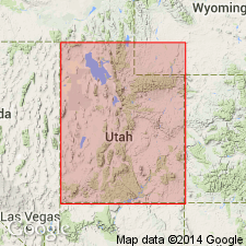
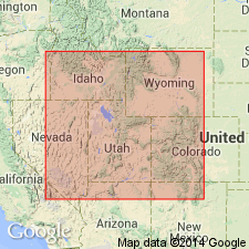
Name proposed for basal member of Woodman Formation, Deep Creek and South Lakeside Mountains (type locality). In Utah, is also basal member of (1) Chainman Shale, Needle Range; (2) Deseret Limestone, Oquirrh Mountains; (3) Brazer Dolomite, Crawford Mountains. In Idaho, is also basal member of (1) Deep Creek Formation, Deep Creek Mountains; (2) Little Flat Formation, Chesterfield Range; and (3) Aspen Range Formation, Aspen Range. All formations are Early to Late Mississippian age. Delle Phosphatic Member occurs in Deseret basin in Idaho, Nevada, Utah, and Wyoming [Great Basin province, UT, NV; Wasatch uplift, UT; Snake River basin, ID]. Areal extent 465 sq mi long and 223 mi wide. Composed of gray to black organic-rich phosphatic claystone, mudstone, shale, siltstone, limestone, bedded radiolarian chert, peloidal phosphorite, cherty micrite, red siltstone, brown pro-deltaic siltstone, coarse debris-flow encrinite. Characterized by dark color, high phosphate content, fine texture, thin bedding, weak resistance to weathering. Is 59 m at type. Attains maximum thickness of about 164 to 197 feet (50 to 60 m). Basal contact is hardground developed on Joana, Lodgepole, Mission Canyon, or Gardison Limestones; upper contact is limestone with Needle Siltstone Member or equivalent, or Tetro Member or equivalent. Fossils: conodonts, radiolarians, forams, planktonic to benthic animals, floating marine and transported land plants. (Conodonts, radiolarians, and agglutinated foraminifers best preserved in micritic limestone concretions.) Delle interpreted to be a deep sediment-starved basin and lower foreslope deposit. Age is Early and Late Mississippian (Osagean and Meramecian), based on fossils (conodonts). Report includes areal extent and isopach maps, correlation chart, measured sections.
Type section: exposures along low ridge, south side Lakeside Mountains, in SE/4 SE/4 SW/4 sec. 6, T. 1 N., R. 8 W., Delle 7.5-min quadrangle, Tooele Co., UT. Named from town of Delle, Tooele Co., UT.
Reference sections designated at Ophir Canyon, Dog Valley Peak (Pavant Range), and Emma Canyon (Crawford Mountains).
Source: Modified from GNU records (USGS DDS-6; Denver GNULEX, Menlo GNULEX).
- Usage in publication:
-
- Delle Phosphatic Member*
- Modifications:
-
- Mapped 1:24k
- Dominant lithology:
-
- Limestone
- Siltstone
- AAPG geologic province:
-
- Great Basin province
Summary:
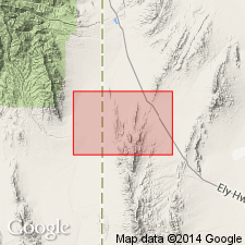
Is basal member of Chainman Formation (Mississippian) and is mapped as two separate map units in northern part of the Mountain Home Range, western Millard Co, southwestern UT (Great Basin province). Subdivisions of the Chainman mostly follow Sadlick (1965) with addition of two members below his Needle Member. Sandberg and others (1980) have listed conodont zones using Sadlick's subdivisions. Overlies Joana Limestone (Osagean and Kinderhookian, Lower Mississippian) and is overlain by Needle Siltstone Member (Meramecian) of the Chainman. Upper map unit described as limestone (Meramecian)--olive-gray limestone that weathers medium gray, medium to thick bedded with distinctive hackly slabby parting; slight phosphatic smell when broken; chert less than one percent, unfossiliferous; forms moderately resistant ridge; thins from 35 m at south edge of map to 25 m where last exposed 3 km northward. Lower map unit described as phosphatic siltstone (Osagean)--thin-bedded, grayish-red phosphatic siltstone that weathers light brown; more calcareous toward top; usually poorly exposed; forms strike valley; thins from 20 m at south edge of map to 13 m where last exposed 3 km northward.
Source: GNU records (USGS DDS-6; Denver GNULEX).

- Usage in publication:
-
- Delle Phosphatic Member*
- Modifications:
-
- Mapped 1:24k
- Dominant lithology:
-
- Limestone
- Siltstone
- AAPG geologic province:
-
- Great Basin province
Summary:
Is basal member of Chainman Formation (Mississippian) and is mapped as two separate map units in southern part of the Mountain Home Range, western Millard and Beaver Cos, southwestern UT (Great Basin province). Subdivisions of the Chainman mostly follow Sadlick (1965, 1966) with addition of Delle Phosphatic Member (Sandberg and Gutschick, 1984) at base of formation. Sandberg and others (1980) have listed Chainman conodont zones using Sadlick's subdivisions. Overlies Joana Limestone (Osagean and Kinderhookian, Lower Mississippian) and is overlain by Needle Siltstone Member (Meramecian) of the Chainman. Upper map unit described as limestone (Meramecian)--olive-gray limestone that weathers medium-gray, medium- to thick-bedded with distinctive hackly slabby parting; slight phosphatic smell when broken; chert less than one percent; forms moderately resistant ridge; about 30 m thick. Lower map unit described as phosphatic siltstone (Osagean)--thin-bedded, grayish-red phosphatic siltstone that weathers light brown; more calcareous toward top; typically poorly exposed; forms strike valley; about 15 m thick.
Source: GNU records (USGS DDS-6; Denver GNULEX).
- Usage in publication:
-
- Delle Phosphatic Member*
- Modifications:
-
- Overview
- AAPG geologic province:
-
- Great Basin province
Summary:
Basal contact of the Delle is sharp and synchronous at or near base of Upper TYPICUS conodont zone of Sandberg. Upper contact of Delle is gradational and differs in age. Top of Delle is younger eastward. Is of Osagean age at all localities. Upper part is early Meramecian in the South Lakeside Mountains where it is the basal member of Woodman Formation, and in Old Laketown Canyon where it is the basal member of Little Flat Formation, Tooele Co, UT in the Great Basin province. Correlation charts.
Source: GNU records (USGS DDS-6; Denver GNULEX).
For more information, please contact Nancy Stamm, Geologic Names Committee Secretary.
Asterisk (*) indicates published by U.S. Geological Survey authors.
"No current usage" (†) implies that a name has been abandoned or has fallen into disuse. Former usage and, if known, replacement name given in parentheses ( ).
Slash (/) indicates name conflicts with nomenclatural guidelines (CSN, 1933; ACSN, 1961, 1970; NACSN, 1983, 2005, 2021). May be explained within brackets ([ ]).