The National Geologic Map Database is migrating to a new infrastructure. We apologize for any service disruptions during this process.
|
|---|


- Usage in publication:
-
- Deep Spring formation*
- Modifications:
-
- Original reference
- Dominant lithology:
-
- Sandstone
- Limestone
- AAPG geologic province:
-
- Great Basin province
Summary:
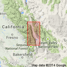
Deep Spring formation. About 1,600 feet of sandstones and dolomitic limestones unconformably underlying Campito sandstone and unconformably overlying Reed dolomite. Age is pre-Cambrian.
Named from exposures along west side of Deep Spring Valley in canyons north of Antelope Spring, [Inyo Mountains], eastern CA.
Source: US geologic names lexicon (USGS Bull. 896, p. 587).
- Usage in publication:
-
- Deep Spring Formation*
- Modifications:
-
- Age modified
- AAPG geologic province:
-
- Great Basin province
Summary:
Age of the Deep Spring Formation is Early Cambrian.
Source: GNU records (USGS DDS-6; Menlo GNULEX).
For more information, please contact Nancy Stamm, Geologic Names Committee Secretary.
Asterisk (*) indicates published by U.S. Geological Survey authors.
"No current usage" (†) implies that a name has been abandoned or has fallen into disuse. Former usage and, if known, replacement name given in parentheses ( ).
Slash (/) indicates name conflicts with nomenclatural guidelines (CSN, 1933; ACSN, 1961, 1970; NACSN, 1983, 2005, 2021). May be explained within brackets ([ ]).