

- Usage in publication:
-
- Cypresshead Formation
- Modifications:
-
- Named
- Dominant lithology:
-
- Sand
- Clay
- AAPG geologic province:
-
- South Georgia sedimentary province
- Atlantic Coast basin
- Florida platform
Summary:
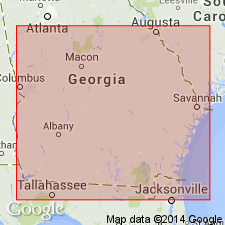
Cypresshead Formation, here named, is the uppermost formation in the section between the Orangeburg Escarpment and the Pamlico terrace, southeastern GA. Unit underlies the coastal area of GA and extends from Dorchester Co., SC, to Orange Co., FL. Cypresshead is predominantly quartz sand, thin- to thick-bedded and massive, planar- to cross-bedded, variably burrowed and bioturbated, fine-grained to pebbly, coarse-grained. Clay beds are prominent in some downdip areas. At the type section near Jessup, GA, the formation disconformably overlies the Ebenezer Member (new name) of the Coosawhatchie Formation; elsewhere disconformably overlies the Charlton Member of the Coosawhatchie, the Marks Head, Parachucla, Altamaha, or Raysor Formations. In the coastal area of GA, disconformably(?) underlies the Satilla Formation; elsewhere underlies only surficial sand or Quaternary fluvial deposits. Grades laterally southward into the Nashua Formation and occupies the same stratigraphic position as the Miccosukee Formation, which lies to the southwest. Thickness is 23 ft (7 m) at the type locality. Maximum thickness appears to be 60 to 70 ft (18 to 21 m). Age of late Pliocene (Piacenzian) inferred from stratigraphic position and physical correlation.
Source: GNU records (USGS DDS-6; Reston GNULEX).
- Usage in publication:
-
- Cypresshead Formation
- Modifications:
-
- Overview
- Areal extent
- AAPG geologic province:
-
- Florida platform
Summary:
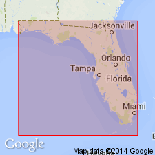
Use of the name Cypresshead Formation is recommended by the Florida Geological Survey to reduce confusion and help interstate correlations. Name applies to sediments in the peninsular area that were previously referred to as the Citronelle or "Citronelle" Formation, Citronelle-like sediments, and the Fort Preston Formation. The Cypresshead is separated from the Citronelle in western FL by the Miccosukee Formation and by a large area where equivalent sediments have been removed by erosion. Unconformably overlies Hawthorn Group throughout much of northern FL. Eastern extent of the Cypresshead in the subsurface has not been determined. Thickest (200 ft) in the Central Highlands (Lake Co.) and absent on the Ocala Platform.
Source: GNU records (USGS DDS-6; Reston GNULEX).
- Usage in publication:
-
- Cypresshead Formation
- Modifications:
-
- Areal extent
- Age modified
- AAPG geologic province:
-
- Florida platform
Summary:
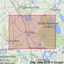
Unit is present over much of the eastern half of Marion Co., east of Ocala. It outcrops in the Ocala National Forest and in southeastern Marion Co. It consists of an orange to white, very fine to coarse clayey sand and some gravel. It is highly variable in thickness and may reach over 100 ft with even greater thicknesses in paleosinks. Overlies the Hawthorn Group and underlies sands, silts, clayey sands, and clays referred to in this report as Undifferentiated sands and clays. Age of the Cypresshead is given as Pliocene-Pleistocene.
Source: GNU records (USGS DDS-6; Reston GNULEX).
- Usage in publication:
-
- Cypresshead Formation
- Modifications:
-
- Areal extent
- AAPG geologic province:
-
- Atlantic Coast basin
Summary:
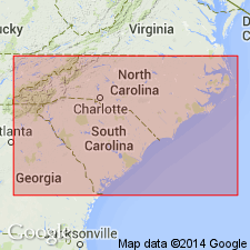
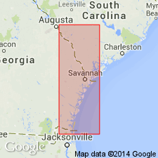
"The Cypresshead and Waccamaw Formations appear to be lateral equivalents." Use of the Cypresshead is recommended for the Charleston area and southward. Huddlestun used this name for the same beds which DuBar and others (1974) mapped as Waccamaw and which Richards (1943), Colquhoun, Herrick and Richards (1968), and Weems and Lemon (1988) mapped as the Penholoway beds. Cypresshead sediments are typically quartz sands and clays with rare but well-preserved marine shells. Sparse fauna indicates a late Pliocene age. The Bear Bluff Formation, considered equivalent to the Cypresshead by other workers, is abandoned in this report.
Source: GNU records (USGS DDS-6; Reston GNULEX).
- Usage in publication:
-
- Cypresshead Formation*
- Modifications:
-
- Biostratigraphic dating
- AAPG geologic province:
-
- Atlantic Coast basin
Summary:
Bear Bluff Formation of southeastern NC and northeastern SC lies above Duplin Formation and is equivalent to Cypresshead Formation of GA. Cypresshead lies above Raysor Formation. Bear Bluff is equivalent to Nashua Formation of northeastern FL. Bear Bluff, Cypresshead, and Nashua are equivalent to Zone PL5 of Berggren (1973) and are assigned a late Pliocene age. Other than limited microfossil data, there is no age control for Cypresshead. Huddlestun (1988) reports juvenile planktic Foraminifera from core in Wayne Co., GA, that suggest age no younger than Pliocene based on GLOBOGERINOIDES OBLIQUS. Benthic Foraminifera VIRGULINELLA GUNTERI from core in Chatham Co., GA, also indicate Pliocene age. Diatom assemblage from core in Byram Co., GA, suggest probable latest Pliocene to early Pleistocene age, including the possible Pliocene forms in genus RAPHONEIS. Assuming all three samples represent same unit, age of Cypresshead ranges from late Pliocene to early Pleistocene. However, authors consider age to be latest late Pliocene and wholly or partially equivalent in age to Bear Bluff Formation of northeastern SC.
Source: GNU records (USGS DDS-6; Reston GNULEX).
For more information, please contact Nancy Stamm, Geologic Names Committee Secretary.
Asterisk (*) indicates published by U.S. Geological Survey authors.
"No current usage" (†) implies that a name has been abandoned or has fallen into disuse. Former usage and, if known, replacement name given in parentheses ( ).
Slash (/) indicates name conflicts with nomenclatural guidelines (CSN, 1933; ACSN, 1961, 1970; NACSN, 1983, 2005, 2021). May be explained within brackets ([ ]).