

- Usage in publication:
-
- Cut Bank Member
- Modifications:
-
- Revised
- Overview
- AAPG geologic province:
-
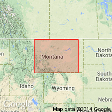
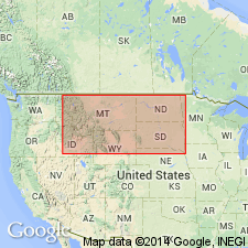
- Sweetgrass arch
Summary:
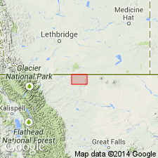
Revised in that the Cut Bank Member of the Kootenai formation is overlain by the Lander Member of the Kootenai in the North Cut Bank field, Glacier Co, MT on the Sweetgrass arch. This report is the first published report to use the Lander member. Type well stated to be the Salt Dome (now Union Oil) Krueger No. 1 NWSW sec 12, T37N, R5W, Glacier Co, MT on the Sweetgrass arch from 2571 to 2642 ft. Lower part is medium- to coarse-grained, dominantly black chert with a basal chert and siltstone pebble clay-lump conglomerate and is commonly pyritic. Upper part is fine- to medium-grained salt and pepper sandstone of about equal proportions of quartz and black to gray chert. Gray green to black carbonaceous shale present in both parts as interbeds and as laminae. Some coaly wood fragments. Is a transgressive fluviatile and lake deposit. Unconformably overlies the Jurassic Rierdon formation of Ellis group. Of Early Cretaceous age. Cross sections.
Source: GNU records (USGS DDS-6; Denver GNULEX).
- Usage in publication:
-
- Cut Bank Sandstone Member*
- Modifications:
-
- Areal extent
- AAPG geologic province:
-
- Sweetgrass arch
Summary:
Cut Bank sand (formerly an economic term) changed to Cut Bank Sandstone Member, a formal unit and the basal member of the Kootenai Formation. Identified in two wells on section A-A' in T36N, R9W and T36N, R6W, Glacier Co, MT on the Sweetgrass arch. In these two wells, Cut Bank unconformably overlies the Jurassic Rierdon Formation and underlies the Lander sandstone (an economic term) of the Kootenai. Of Early Jurassic age.
Source: GNU records (USGS DDS-6; Denver GNULEX).
- Usage in publication:
-
- Cut Bank Sandstone Member*
- Modifications:
-
- Revised
- AAPG geologic province:
-
- Sweetgrass arch
Summary:
Cut Bank Sandstone Member, basal member of Kootenai Formation. Cut Bank sand (economic term) adopted as Cut Bank Sandstone Member of Kootenai Formation, as defined by Oakes (1966). Consists of a well-sorted sandstone usually divided into two benches by a mudstone. Underlies Sunburst Sandstone Member (revised) of Kootenai (=Oakes' Lander Member).
Type section (subsurface): depth-interval 2,571 to 2,642 ft (748 m to 805 m), Salt Dome [now Union Oil] Krueger No. 1 well, in NW/4 SW/4 sec. 12, T. 37 N., R. 5 W., Glacier Co., MT (Oakes, 1966, p. 196).
Source: Changes in stratigraphic nomenclature, 1975 (USGS Bull. 1422-A, p. A10-A11, A66-A67).
- Usage in publication:
-
- Cut Bank Sandstone Member*
- Modifications:
-
- Reference
- Revised
- Areal extent
- AAPG geologic province:
-
- Sweetgrass arch
Summary:
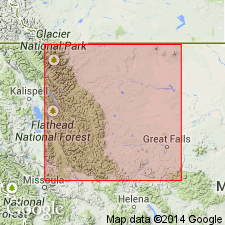
Extended from Cut Bank area where it is basal member of Kootenai Formation to Sawtooth Range, Teton Co, MT on the Sweetgrass arch where it is basal member of Mount Pablo Formation (new). Reference section designated along Badger Creek in NE1/4 SW1/4 sec 3, T29N, R11W, Blackfeet Indian Reservation, Pondera Co, where it is 11 m thick. Composed of gray-yellow, cross-bedded, medium- to coarse-grained, poorly sorted conglomeratic sandstone; gray shale; coarse-grained to very fine grained, poorly sorted, cross-bedded to massive sandstone. Overlies Swift Formation unconformably and underlies middle part of Mount Pablo. Locally overlies Morrison Formation unconformably. Locally unconformably overlies Swift Formation. East of limit of Cut Bank as member of Mount Pablo shown on fig. 12. Is of Early Cretaceous age.
Source: GNU records (USGS DDS-6; Denver GNULEX).
For more information, please contact Nancy Stamm, Geologic Names Committee Secretary.
Asterisk (*) indicates published by U.S. Geological Survey authors.
"No current usage" (†) implies that a name has been abandoned or has fallen into disuse. Former usage and, if known, replacement name given in parentheses ( ).
Slash (/) indicates name conflicts with nomenclatural guidelines (CSN, 1933; ACSN, 1961, 1970; NACSN, 1983, 2005, 2021). May be explained within brackets ([ ]).