The National Geologic Map Database is migrating to a new infrastructure. We apologize for any service disruptions during this process.
|
|---|


- Usage in publication:
-
- Corset Spring shale
- Modifications:
-
- Original reference
- Dominant lithology:
-
- Shale
- AAPG geologic province:
-
- Great Basin province
Summary:
Pg. 104 (fig. 1), 106 (fig. 2), 108 (fig. 3), 115-116, 117 (measured section). Corset Spring shale. A 65-foot unit of olive-gray predominantly clay shale with characteristic pencil fracture that overlies Johns Wash limestone (new). Near middle of formation, at type section, is 17 feet of medium-gray thick-bedded medium-coarse, crystalline, and clastic limestone unit separating a lower shale unit from an upper one. Collection from base of this limestone unit (USGS fossil loc. 1195-C0) yielded trilobites BURNETIA sp., CHEILOCEPHALUS sp., DUNDERBERGIA sp., ELVINIA sp., HOUSIA sp., LINNARSSONELLA GIRTYI Walcott, and PTEROCEPHALIA sp. Fossils characteristic of ELVINIA zone of standard Late Cambrian sequence. These trilobites are also present in the upper part of the Dunderberg shale of the Eureka district, Nevada, and some of the species are present in the Mendha formation of the Pioche district, Nevada (Wheeler and Lemmon, 1939, Univ. Nevada Bull., v. 33), and in the Orr formation, House Range, Utah (Wheeler and Steele, 1951, Gdbk. Geol. Utah, no. 6). Distribution of Corset Spring irregular because thrust fault commonly follows unit. Undisturbed sections show sharp lower contact and a gradational upper contact with overlying (unnamed) cherty limestone. Upper contact is placed at highest shale in a sequence of alternating shale and limestone lenses.
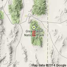
Type section: segment B of measured section (see fig. 2), southern Snake Range, Nevada. No suitable geographic name near this section but there is alternate section at elevation 10,500 above Corset Spring [now unnamed or no longer exists] on northeast flank of peak 11,064 [now labeled peak 11,001], two miles east of Lincoln Peak, and shale is named for that spring. Corset Spring shown on fig. 1; [in area btw. North Fork and South Fork Big Wash, in T. 12 N., R. 69 E., western edge Garrison 15-min quadrangle (1951 ed.), Nevada National Forest (now Humboldt National Forest), White Pine Co., western NV.]
Source: Publication; US geologic names lexicon (USGS Bull. 1200, p. 947-948).
- Usage in publication:
-
- Corset Spring shale
- Modifications:
-
- Not used
- AAPG geologic province:
-
- Great Basin province
Summary:
Pg. 21-22. Corset Spring shale. Dunderberg shale is basal Franconian and is equivalent to a sandstone, shale, and limestone unit about 600 feet above base of Mendha limestone at Pioche, Nevada. Dunderberg is present in Snake Range, Nevada, where Drewes and Palmer (1957) called it Corset Spring shale. Although they correlated it with Dunderberg shale of Eureka, Nevada, and found basal Franconian fossils, they designated it as Trempealeauan (Drewes, 1958). Underlying Corset Spring shale is 228 feet of limestone designated by Drewes and Palmer the Johns Wash limestone, supposedly of late Franconian and basal Trempealeauan age. Present writer [Bentley] does not agree with this dating or with nomenclature involved. Formation names used by Drewes and Palmer, at least those for Upper Cambrian, should be suppressed, and section renamed with either Eureka district or House Range terminology.
Source: US geologic names lexicon (USGS Bull. 1200, p. 947-948).
- Usage in publication:
-
- Corset Spring shale*
- Modifications:
-
- Areal extent
- AAPG geologic province:
-
- Great Basin province
Summary:
Pg. 224 (fig. 2), 226-227, pl. 1 (geol. map). Corset Spring shale. Trilobite assemblage indicates early Trempealeau age [Late Cambrian]. Formation probably correlative of part of Dunderberg shale of Eureka district, Nevada, and part of Mendha formation of Pioche district, Nevada.
Source: US geologic names lexicon (USGS Bull. 1200, p. 947-948).
- Usage in publication:
-
- Corset Spring shale*
- Modifications:
-
- Areal extent
- AAPG geologic province:
-
- Great Basin province
Palmer, A.R., 1960, Identification of the Dunderberg Shale of Late Cambrian age in the eastern Great Basin; Article 132: U.S. Geological Survey Professional Paper, 400-B, p. B289-B290.
Summary:
Pg. 289-290. Corset Spring shale. Unit that bas been called "Dunderberg shale" by Bentley and by those who have studied it in western Utah is not equivalent to whole of Dunderberg shale exposed near Eureka and Cherry Creek, Nevada. Evidence indicates that name "Dunderberg shale" should no longer be used for a thin unit of interbedded limestones and shales occurring in western Utah and containing ELVINA zone trilobites. This unit is better named Corset Spring shale. Bentley has pointed out correctly that the Corset Spring shale, which occurs in Snake Range just west of Nevada-Utah line, is equivalent to his "Dunderberg shale." Name Corset Spring extended into Deep Creek Range, where it occurs above Hicks formation and below Chokecherry dolomite.
Source: US geologic names lexicon (USGS Bull. 1200, p. 947-948).
- Usage in publication:
-
- Corset Spring Shale Member*
- Modifications:
-
- Revised
- AAPG geologic province:
-
- Great Basin province
Summary:
Corset Spring Shale Member of Orr Formation.
Reduced in stratigraphic rank from Corset Spring Shale to a member of Orr Formation in the House Range of western UT in Great Basin province. Is a bench- and slope-forming unit between the underlying Johns Wash Limestone Member (reduced in stratigraphic rank) and the overlying Sneakover Limestone Member (new). Is composed of two gray, mottled, silty calcisiltite beds separated by dark- to light-gray, oolitic limestone 145 ft (442 m) thick at type section of Orr (T18S, R13W) where section was measured. Is of Late Cambrian age. Considered a formation in the southern Snake Range, NV. Correlates with part of Hicks Formation of Deep Creek Range, UT; Straight Canyon Formation of Dugway Range, UT; and Opex Formation of East Tintic Mountains, UT.
Lies within ELVINIA trilobite assemblage zone.
Recognized in House Range.
Source: GNU records (USGS DDS-6; Denver GNULEX).
For more information, please contact Nancy Stamm, Geologic Names Committee Secretary.
Asterisk (*) indicates published by U.S. Geological Survey authors.
"No current usage" (†) implies that a name has been abandoned or has fallen into disuse. Former usage and, if known, replacement name given in parentheses ( ).
Slash (/) indicates name conflicts with nomenclatural guidelines (CSN, 1933; ACSN, 1961, 1970; NACSN, 1983, 2005, 2021). May be explained within brackets ([ ]).