

- Usage in publication:
-
- Claggett formation*
- Modifications:
-
- Named
- Dominant lithology:
-
- Shale
- AAPG geologic province:
-
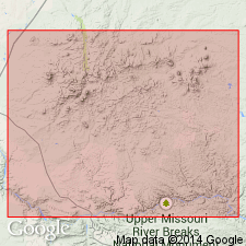
- Central Montana uplift
Summary:
Named for old Fort Claggett at mouth of the Judith River, Fergus Co, MT on the Central Montana uplift, where formation is well developed. No type locality designated. Consists of 400 ft of fossiliferous shale. Has several sandstone beds in the upper 200 ft which have a Fox Hills fauna. This upper part was called Fox Hills in earlier reports. Overlies Eagle formation. Underlies Judith River beds. Of Late Cretaceous age.
Source: GNU records (USGS DDS-6; Denver GNULEX).
- Usage in publication:
-
- Claggett shale member*
- Modifications:
-
- Mapped 1:63k
- Revised
- AAPG geologic province:
-
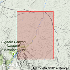
- Powder River basin
Summary:
Reduced in rank and assigned as uppermost member of seven members (formal and informal) of Cody shale (revised). Mapped in northeastern part of study area, Big Horn Co, MT, northwestern Powder River basin. As shown on measured section (sheet 2), Claggett is 367 ft thick and consists of dark gray shale; bentonitic in lower part. Overlies "shale member equivalent to Eagle sandstone" of Cody; underlies Parkman sandstone. Late Cretaceous age.
Source: GNU records (USGS DDS-6; Denver GNULEX).
- Usage in publication:
-
- Claggett Shale*
- Modifications:
-
- Biostratigraphic dating
- Geochronologic dating
- AAPG geologic province:
-
- Central Montana uplift
- Powder River basin
Summary:
Claggett Shale. Samples collected from:
(1) an 85-cm-thick bentonite near top of BACULITES OBTUSUS or at base of B. MCLEARNI ammonite zone, 22 m above base of type Claggett Shale, in SW/4 SE/4 NW/4 sec. 14, T. 22 N., R. 16 E., Fergus Co., MT (central Montana uplift). K-Ar age on biotite 77.9 Ma (weighted mean). Age is Late Cretaceous (Campanian).
(2) a 58-cm-thick bentonite (bed T) within the B. OBTUSUS ammonite zone, in lower part of Claggett Shale, about 7 mi east of Hardin, in NE/4 NE/4 sec. 13, T. 1 S., R. 34 E., Bighorn Co., MT (northern Powder River basin). K-Ar age on biotite 77.5 +/-0.8 Ma. Age is Late Cretaceous (Campanian).
(3) a 2-m-thick bentonite (bed R) within the BACULITES sp. (weak flank ribs) ammonite zone, about 60 m below previous sample at same locality. K-Ar age on biotite 78.2 +/-0.8 Ma. Age is Late Cretaceous (Campanian).
Source: Modified from GNU records (USGS DDS-6; Denver GNULEX).
For more information, please contact Nancy Stamm, Geologic Names Committee Secretary.
Asterisk (*) indicates published by U.S. Geological Survey authors.
"No current usage" (†) implies that a name has been abandoned or has fallen into disuse. Former usage and, if known, replacement name given in parentheses ( ).
Slash (/) indicates name conflicts with nomenclatural guidelines (CSN, 1933; ACSN, 1961, 1970; NACSN, 1983, 2005, 2021). May be explained within brackets ([ ]).