The National Geologic Map Database is migrating to a new infrastructure. We apologize for any service disruptions during this process.
|
|---|


- Usage in publication:
-
- Bull Creek sandstone
- Modifications:
-
- Original reference
- Dominant lithology:
-
- Sandstone
- AAPG geologic province:
-
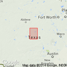
- Bend arch
- Llano uplift
Summary:
Pg. 374, 379. Bull Creek sandstone in Strawn division. Sandstones, largely in flaggy layers 6 inches to 4 feet thick; white on fresh surfaces, weathering grayish. Thickness 50 to 75 feet. Member of Strawn division [Strawn is 2nd from base of 5 Carboniferous divisions of Cummins, 1891]. Overlies Horse Creek clays and shales and underlies Big Valley bed. Age is Pennsylvanian.
[Named from Bull Creek, Mills Co., Colorado River region, central TX.]
Source: US geologic names lexicon (USGS Bull. 896, p. 290).
- Usage in publication:
-
- Bull Creek sandstone
- Modifications:
-
- Areal extent
- AAPG geologic province:
-
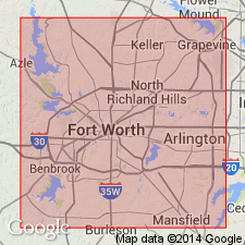
- Fort Worth syncline
Summary:
Pg. 72. Bull Creek sandstone in Strawn series. Largely white flaggy layers, weather grayish. Thickness 50 to 75 feet. Underlies Big Valley bed; overlies Horse Creek clays and shales. [Age is Pennsylvanian; age of Strawn not discussed.]
[Report area in Parker County, central Texas.]
Source: US geologic names lexicon (USGS Bull. 1200, p. 527); supplemental information from GNU records (USGS DDS-6; Denver GNULEX).
- Usage in publication:
-
- Bull Creek sandstone
- Modifications:
-
- Not used
- AAPG geologic province:
-
- Bend arch
Summary:
Pg. 58, pl. 27. [†Bull Creek sandstone in Strawn formation not used by the USGS; a local term considered obsolete. See also entry under Strawn.] Drake (1893) separated rocks of Strawn group [division] into 20 units of alternating sandstone and shale beds. He gave local names to these units, or "beds" as he termed them, and numbered them from bottom to top, 4 to 23. Only Drake's name for upper unit, the Ricker, is in common use today, and that name has been restricted to the base of Drake's Ricker bed.
Source: US geologic names lexicon (USGS Bull. 1200, p. 527).
For more information, please contact Nancy Stamm, Geologic Names Committee Secretary.
Asterisk (*) indicates published by U.S. Geological Survey authors.
"No current usage" (†) implies that a name has been abandoned or has fallen into disuse. Former usage and, if known, replacement name given in parentheses ( ).
Slash (/) indicates name conflicts with nomenclatural guidelines (CSN, 1933; ACSN, 1961, 1970; NACSN, 1983, 2005, 2021). May be explained within brackets ([ ]).