

- Usage in publication:
-
- Buda limestone*
- Modifications:
-
- Original reference
- Dominant lithology:
-
- Limestone
- AAPG geologic province:
-
- Ouachita folded belt
Summary:
Pg. 18. Buda limestone. Hard, whitish or yellowish limestone, weathering yellowish or pinkish. Thickness 100 feet. Top formation of Lower Cretaceous (Comanche series). Overlies Del Rio clays. Replaces Shoal Creek limestone, preoccupied. [Age is Early Cretaceous (Comanche).]
[Named from Buda, Hays Co., southeastern TX.]
Source: US geologic names lexicon (USGS Bull. 896, p. 286).

- Usage in publication:
-
- Buda limestone*
- Modifications:
-
- Overview
Summary:
Buda limestone of Washita group. Top formation of Washita group in southern central and eastern Texas. Overlies Del Rio clay and underlies Eagle Ford shale. Age is Early Cretaceous (Comanche).
Source: US geologic names lexicon (USGS Bull. 896, p. 286).
- Usage in publication:
-
- Buda limestone*
- Modifications:
-
- Areal extent
Summary:
Correlation chart shows Buda limestone in Washita group, Upper Cretaceous (lower Cenomanian). Overlies Grayson shale. Present in Chihuahua, Mexico. [Age is Late Cretaceous (Comanche).]
Source: US geologic names lexicon (USGS Bull. 1200, p. 518-519).
- Usage in publication:
-
- Buda limestone
- Modifications:
-
- Areal extent
- AAPG geologic province:
-
- Permian basin
Summary:
Pg. 1138 (table 1), 1140-1141, pl. 1. Buda limestone of Washita group. Described in Buck Hill quadrangle, west-central Brewster County, Trans-Pecos Texas, where it is 65 to 68 feet thick. Disconformably overlies Grayson clay; disconformably underlies Boquillas formation. Age is Early Cretaceous.
Source: Publication; US geologic names lexicon (USGS Bull. 1200, p. 518-519).
- Usage in publication:
-
- Buda limestone*
- Modifications:
-
- Areal extent
- AAPG geologic province:
-
- Permian basin
Summary:
Pg. 10 (table 1), 13, 31, pl. 1. Buda limestone of Washita group. Described in Eagle Mountains, Hudspeth County, Texas, where it underlies Eagle Ford formation and overlies Eagle Mountains sandstone member (new) of Grayson formation. Maximum thickness 225 feet. Age is Late Cretaceous.
Source: Publication; US geologic names lexicon (USGS Bull. 1200, p. 518-519).
- Usage in publication:
-
- Buda limestone
- Modifications:
-
- Revised
- AAPG geologic province:
-
- Permian basin
Summary:
Buda limestone of Sixshooter group. In Wylie Mountains and vicinity, uppermost formation in Sixshooter group (new). Overlies Boracho formation (new); overlain with angular discordance by Tertiary volcanic strata. Thickness 40 to 150 feet. [Age is Late Cretaceous (Comanche).]
Source: US geologic names lexicon (USGS Bull. 1200, p. 518-519).
- Usage in publication:
-
- Buda limestone
- Modifications:
-
- Areal extent
- AAPG geologic province:
-
- Permian basin
Summary:
Pg. 374 (fig. 2), 385-386. Buda limestone of Sixshooter group. Described in Kent quadrangle [Culberson, Reeves, and Jeff Davis Counties, western Texas] where it is uppermost formation in Sixshooter group. Unconformably overlies San Martine member (new) of Boracho formation; unconformably underlies Boquillas flags. Thickness 160 feet. Age is Late Cretaceous (Cenomanian).
Source: US geologic names lexicon (USGS Bull. 1200, p. 518-519).
- Usage in publication:
-
- Buda limestone*
- Modifications:
-
- Areal extent
- AAPG geologic province:
-
- Permian basin
Summary:
Pg. 10, pl. 1. Buda limestone of Washita group. Described in Terlingua district, Texas, where it is commonly 90 feet thick, overlies Grayson formation and underlies Boquillas flags. Age is Late Cretaceous (Comanche).
Source: US geologic names lexicon (USGS Bull. 1200, p. 518-519).
- Usage in publication:
-
- Buda limestone
- Modifications:
-
- Areal extent
- AAPG geologic province:
-
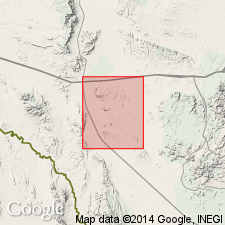
- Ouachita folded belt
Summary:
p. 70 (fig. 3), 74 (fig. 5), 90-92. Buda limestone. Described in Purgatory Creek area, Texas, where it is 40 feet thick, overlies Del Rio clay and unconformably underlies Eagle Ford formation. [Age is Late Cretaceous (Comanche).]
Source: US geologic names lexicon (USGS Bull. 1200, p. 518-519).

- Usage in publication:
-
- Buda limestone
- Modifications:
-
- Areal extent
- AAPG geologic province:
-
- Fort Worth syncline
Summary:
Pg. 9 (fig. 3), 12 (fig. 4), 41-42, pl. 2. Buda limestone of Washita group. At Grayson Bluff, southern Denton County, Texas, the Buda consists of clastic coquinitic buff to yellow limestone about 18 inches thick. Unconformable with overlying Denison formation; contact with overlying Woodbine is irregular surface of erosion. Washita group. Age is Late Cretaceous.
Source: US geologic names lexicon (USGS Bull. 1200, p. 518-519).
- Usage in publication:
-
- Buda Limestone*
- Modifications:
-
- Mapped 1:62.5k
- Dominant lithology:
-
- Limestone
- AAPG geologic province:
-
- Permian basin
Summary:
Is formation mapped in eastern Brewster and southwest Terrell Cos, TX in Permian basin. Overlies Grayson Formation (Del Rio Clay of former usage) with erosional unconformity; underlies Boquillas Flags with erosional unconformity. Map unit described as upper and lower unit of light yellowish-gray to pale-orange, thick- to very thick-bedded dense porcelaneous limestone, not visibly crystalline except for specks that are probably fossil remains; fossiliferous, breaks with conchoidal fracture, weathers to lighter colored hackly or vaguely nodular surface. Middle unit of yellowish-gray, thin- to thick-bedded, fossiliferous limestone and clayey limestone; weathers nodular, commonly poorly exposed on slope. Thickens westward from 78 to 90 ft. Structure contour drawn on top of Buda. Age is Late Cretaceous.
Source: GNU records (USGS DDS-6; Denver GNULEX).

- Usage in publication:
-
- Buda Limestone
- Modifications:
-
- Mapped 1:250k
- Dominant lithology:
-
- Limestone
- AAPG geologic province:
-
- Ouachita folded belt
Summary:
Buda Limestone. Limestone, bioclastic, hard, massive, porous, poorly bedded to nodular; abundant pelecypods, burrows filled with chalky marl. Thickness up to 10 feet; discontinuous outcrop from China Springs southward. Lies above Grayson Marl ("Del Rio Clay," Lower Cretaceous) and below Pepper Shale (Upper Cretaceous). Age is Early Cretaceous.
Mapped south of Brazos River, in McLennan and Bell Cos., eastern TX.
Source: Publication.
- Usage in publication:
-
- Buda Formation
- Modifications:
-
- Areal extent
- AAPG geologic province:
-
- Orogrande basin
Summary:
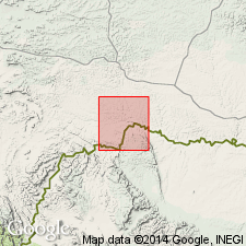
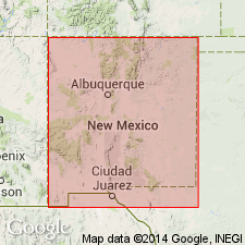
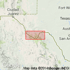
Mapped in Cerro de Cristo Rey, Dona Ana Co, NM, Orogrande basin and Chihuahua, MX. Most extensive outcrops are on north, east, and south sides of Cerro de Cristo Rey intrusion. Thickness is 12 m. Buda is a competent limestone between incompetent shales which are Del Rio Formation (conformably below) and Boquillas Formation (unconformably above). Cross sections. Locally, contains many gastropods, but only a few GRYPHAEA. Assigned Early Cretaceous (Cenomanian, Comanchean) age. [Author places lower part of Cenomanian in Lower Cretaceous.]
Source: GNU records (USGS DDS-6; Denver GNULEX).

- Usage in publication:
-
- Buda Limestone
- Modifications:
-
- Mapped 1:250k
- Dominant lithology:
-
- Limestone
- AAPG geologic province:
-
- Ouachita folded belt
- Permian basin
Summary:
Buda Limestone. Fine-grained, bioclastic, commonly glauconitic, pyritiferous, hard, massive, poorly bedded to nodular, thinner bedded and argillaceous near upper contact, light-gray to pale-orange; weathers dark-gray to brown; burrows filled with chalky marl, abundant pelecypods. Thickness 45 to 100 feet, thickens eastward. Overlies Del Rio Clay. Age is Late Cretaceous.
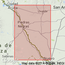
Mapped in Terrell, Uvalde, and Val Verde Cos., TX.
Source: Publication; supplemental information from GNU records (USGS DDS-6; Denver GNULEX).
- Usage in publication:
-
- Buda Limestone
- Modifications:
-
- Mapped 1:250k
- Dominant lithology:
-
- Limestone
- AAPG geologic province:
-
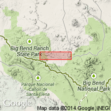
- Permian basin
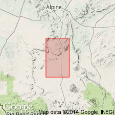
Summary:
Buda Limestone. In Big Bend National Park and eastward divisible into three parts: (1) upper unit, limestone, microgranular, porcelaneous, hard, conchoidal fracture, grayish-white, up to 60 feet thick; (2) middle unit, limestone, argillaceous, marly, nodular, weathers to a lumpy surface, grayish-white, about 30 feet thick; (3) and lower unit, similar to upper unit, about 25 feet thick. Total thickness 80 feet in Hood Spring and Santiago Peak quadrangles, and 61 feet in Tascotal Mesa quadrangle. Overlies Del Rio Clay. Underlies Boquillas Flags (Upper Cretaceous) in eastern part of sheet; elsewhere, underlies Ernst Member, lower member of Boquillas Formation. Age is Early Cretaceous.
Mapped (undifferentiated) with Del Rio Clay in Terrell, Brewster, and Presidio Cos., TX.
Source: Publication; supplemental information from GNU records (USGS DDS-6; Denver GNULEX).

- Usage in publication:
-
- Buda Limestone
- Modifications:
-
- Mapped 1:250k
- Dominant lithology:
-
- Limestone
- AAPG geologic province:
-
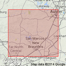
- Kerr basin
- Ouachita folded belt
Summary:
Pamphlet [p. 5]. Buda Limestone. Limestone, fine-grained, bioclastic, commonly glauconitic, pyritiferous, hard, massive, poorly bedded to nodular, thinner bedded and argillaceous near upper contact, light-gray to pale-orange; weathers dark-gray to brown; burrows filled with chalky marl, abundant pelecypods. Thickness 60 to 100 feet; thickens westward. Overlies Del Rio Clay; underlies Eagle Ford Group, undivided. Locally (e.g. eastern Medina and western Bexar Counties), Del Rio, Buda, and Eagle Ford are faulted-out entirely. Age is Late Cretaceous.
Mapped in Kerr, Real, Uvalde, Medina, Bexar, Comal, and Hays Cos., TX; mapped areas are small and generally fault-bounded.
[Misprint (1974 ed.): Del Rio Clay and Buda Limestone assigned to Lower Cretaceous in pamphlet that accompanies map, but assigned to Upper Cretaceous on map sheet explanation. Both Del Rio and Buda are Upper Cretaceous (corrected in 1983 revised ed.).]
Source: Publication; supplemental information from GNU records (USGS DDS-6; Denver GNULEX).
For more information, please contact Nancy Stamm, Geologic Names Committee Secretary.
Asterisk (*) indicates published by U.S. Geological Survey authors.
"No current usage" (†) implies that a name has been abandoned or has fallen into disuse. Former usage and, if known, replacement name given in parentheses ( ).
Slash (/) indicates name conflicts with nomenclatural guidelines (CSN, 1933; ACSN, 1961, 1970; NACSN, 1983, 2005, 2021). May be explained within brackets ([ ]).