


- Usage in publication:
-
- Brownstown marl
- Modifications:
-
- Restricted
Summary:
Brownstown marl (restricted). In 1926 L.W. Stephenson and C.H. Dane (USGS Press Bull. 8823, Sept. 10), 1927 (AAPG Bull., v. 11, p. 8), and 1929 (Arkansas Geol. Survey Bull. 1, p. 46) divided †Bingen sand into Woodbine sand below and Tokio formation above, and restricted Brownstown marl to lower part of Veatch's [1906, USGS Prof. Paper 46, p. 25] Brownstown marl, the new name Ozan formation being applied to the upper unconformable part of the Brownstown of Veatch. The village of Brownstown, Sevier County, Arkansas, is located on top of Brownstown marl as thus restricted by Stephenson and Dane. According to L.W. Stephenson, 1928 (Amer. Jour. Sci., 5th, v. 16, p. 429), and 1929 (AAPG Bull., v. 13, no. 10), the Brownstown marl overlies Bonham clay and unconformably underlies Annona chalk in northeastern Texas.
Source: US geologic names lexicon (USGS Bull. 896, p. 276).

- Usage in publication:
-
- Brownstown Marl
- Modifications:
-
- Mapped 1:250k
- Dominant lithology:
-
- Marl
- Clay
- AAPG geologic province:
-
- Arkla basin
- Ouachita folded belt
Summary:
Brownstown Marl. In Texas, marl and clay, in part sandy, glauconitic at base, phosphatic, some calcareous septaria in Lamar and Fannin Counties, dark-gray; weathers yellowish-gray; marine megafossils common; thickness 80-175 feet, thins westward. In Arkansas [and Oklahoma], marl, in part samdy, sand fine-grained; abundant marine megafossils; thickness 220 feet. [Overlies Blossom Sand; in Arkansas and Oklahoma, overlies Tokio Formation. Underlies Gober Chalk; where Gober is absent underlies Ozan Formation or locally Anonna Chalk.] Age is Late Cretaceous.
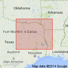
[Mapped in mostly continuous belt south of Red River, in Fannin, Lamar, and Red River Cos., northeastern TX; and locally in northeastern part of map sheet in Little River and Sevier Cos., AR, and McCurtain Co., OK.]
Source: Publication.
- Usage in publication:
-
- Brownstown Marl*
- Modifications:
-
- Paleomagnetics
- AAPG geologic province:
-
- Ouachita folded belt
Summary:
Paleomagnetic (a.f. demagnetized) data indicates the Upper Cretaceous Brownstown Marl in the Ouachita tectonic belt province in southwest AR possesses a remanent magnetization of reversed magnetic polarity. The deposit is correlated with the Gubbio (Italy) reversed polarity zone A (early Campanian).
Source: GNU records (USGS DDS-6; Denver GNULEX).
- Usage in publication:
-
- Brownstown? Formation
- Modifications:
-
- Biostratigraphic dating
- AAPG geologic province:
-
- Ouachita folded belt
Summary:
Is formation composed of fossil-bearing gravel, sand, and clay questionably assigned to Brownstown Formation; exposed in quarry (in SE/4 NE/4 sec. 15, T. 6 S., R. 19 W.) in the Ouachita tectonic belt province. Overlies Jackfork Sandstone (Lower Pennsylvanian) with angular unconformity; is capped by Tertiary/Quaternary terrace deposit. Fossiliferous gravel occupies small depressions between east-west ridges in underlying Jackfork; basal gravel is exposed for distance of about 60 m with maximum thickness of less than 1 m; top of fossiliferous bed is flat and underlies covered interval as thick as about 2 m, which in turn underlies 9 to 10 m of fine-grained, thin-bedded marine sand and clay. Gravel in depression is matrix-supported (in part) and consists mainly of dark-gray to light-gray and greenish-gray, well-rounded, poorly sorted chert pebbles as much as 6 cm in diameter; matrix consists of clear, angular, poorly sorted quartz grains and tough, gray, calcareous clay with nannoplankton. Basal gravel deposited in high-energy marine rocky coast environment open to the sea; overlain by lower shoreface sand and clay. Megafauna in gravel belongs to EXOGYRA PONDEROSA Assemblage Zone. Significant associated coccoliths CERATOLITHOIDES ACULEUS, BROINSONIA PARCA, and QUADRUM NITIDUM indicate Late Cretaceous age (middle to late Campanian; NP21-23).
Source: GNU records (USGS DDS-6; Denver GNULEX).

- Usage in publication:
-
- Brownstown Marl
- Modifications:
-
- Mapped 1:250k
- Dominant lithology:
-
- Clay
- AAPG geologic province:
-
- Ouachita folded belt
Summary:
Pamphlet [p. 3]. Brownstown Marl of Austin Group. Clay, medium-yellowish-gray, weathers to light-yellowish-gray, calcareous, silty, poorly bedded to massive, marine megafossils scarce. Thickness approximately 80 feet, feathers out westward near Bonham [Fannin County, northeastern Texas]. Lies above Blossom Sand and below Gober Chalk; both of Austin Group. Age is Late Cretaceous.
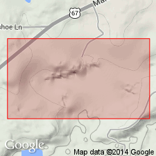
[Mapped in Bonham area, central eastern edge of map sheet, Fannin Co., northeastern TX.]
Source: Publication.
For more information, please contact Nancy Stamm, Geologic Names Committee Secretary.
Asterisk (*) indicates published by U.S. Geological Survey authors.
"No current usage" (†) implies that a name has been abandoned or has fallen into disuse. Former usage and, if known, replacement name given in parentheses ( ).
Slash (/) indicates name conflicts with nomenclatural guidelines (CSN, 1933; ACSN, 1961, 1970; NACSN, 1983, 2005, 2021). May be explained within brackets ([ ]).