


- Usage in publication:
-
- Bowie Group
- Modifications:
-
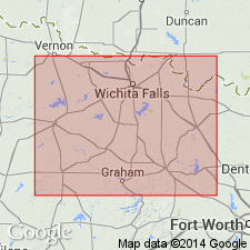
- Areal extent
- Dominant lithology:
-
- Mudstone
- Shale
- Sandstone
- Limestone
- Conglomerate
- AAPG geologic province:
-
- Bend arch
- Fort Worth syncline
Summary:
Bowie Group. Divided into (descending) Archer City and Markley Formations (both new). Lies above Canyon Group and below Wichita Group. [Correlative with upper part of Ciscos Group (Santa Anna Branch, Sedwick, Moran, Pueblo, and Harpersville formations) mapped in southern part of sheet; stratigraphic cuttoff in Young and Throckmorton Cos., northern TX.] Age is Late Pennsylvanian(?) to Early Permian (Virgilian? to Wolfcampian).
Source: Publication.
- Usage in publication:
-
- Bowie Group
- Modifications:
-
- Principal reference
- Dominant lithology:
-
- Sandstone
- Mudstone
- Siltstone
- Conglomerate
- Coal
- AAPG geologic province:
-
- Bend arch
- Fort Worth syncline
Summary:
Named (after informal usage of Brown, 1969, West Texas Geol. Soc. Pub. 69-56, p. 115-134). Divided into Markley (base) and Archer City Formations (top); both new. Bowie rocks are exposed in Trinity and parts of Little Wichita and Red River drainages in northern and western Young, northern Jack, southeastern Archer, southern Clay, and Montague Counties, north-central Texas. Cisco Group used to the south. Bowie represents upslope equivalent of Cisco, and shown in section extending from top of Home Creek Limestone (or equivalents) of Canyon Group to base of lowest sandstone member of Nocona Formation (new) of Wichita Group (revised). Bowie rocks are dominantly nonmarine (fluvial-channel sandstones and floodbasin mudstones). Equivalent strata occur in subsurface in southern Oklahoma and extreme northern Texas. Age of Bowie Group is Late Pennsylvanian (Virgilian) and Early Permian (Wolfcampian). Report includes sections, geologic map.
Type locality not designated for Bowie Group, but each component formation is assigned a stratotype representing either (a) one or several fluviogenic cycles or (b) the general lithology of a noncyclic sequence. Markley Formation (at its stratotype) has 15 sandstone members; some conglomerate at top; interbeds of mudstone, some with calcareous nodules; thin coal in lower part. Archer City Formation (at its stratotype) has 9 sandstone members with intervening mudstone, some with calcareous nodules; fairly thin siltstone layer near middle.
Source: Modified from GNU records (USGS DDS-6; Denver GNULEX).
For more information, please contact Nancy Stamm, Geologic Names Committee Secretary.
Asterisk (*) indicates published by U.S. Geological Survey authors.
"No current usage" (†) implies that a name has been abandoned or has fallen into disuse. Former usage and, if known, replacement name given in parentheses ( ).
Slash (/) indicates name conflicts with nomenclatural guidelines (CSN, 1933; ACSN, 1961, 1970; NACSN, 1983, 2005, 2021). May be explained within brackets ([ ]).