

- Usage in publication:
-
- Blue Mesa Tuff*
- Modifications:
-
- Original reference
- Dominant lithology:
-
- Tuff
- AAPG geologic province:
-
- Paradox basin
- Piceance basin
Summary:
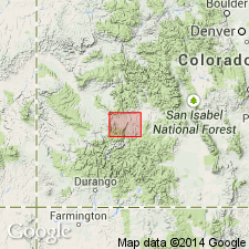
Pg. C9, C14-C15, pl. 1. Blue Mesa Tuff. Reddish-brown densely welded devitrified tuff; includes gravel bed at base; commonly forms jointed vertical cliffs 50 to 200 feet high in outer walls of Black Canyon and its tributaries. Underlies Dillon Mesa Tuff; overlies older Tertiary volcanics [West Elk Breccia, Lake Fork Formation; to south in Lake City and Silverton areas, overlies Ute Ridge Tuff of Lipman and others (1973)]. Rocks previously included in the lower member of Alboroto Rhyolite of Potosi Volcanic Series by Larsen and Cross (1956, USGS Prof. Paper 258). Age is late Oligocene.
Type locality: exposures in rim of Blue Mesa, south side Black Canyon above Blue Mesa dam, [probably in SW/4 NW/4 sec. 8, T. 48 N., R. 4 W.], Sapinero 7.5-min quadrangle, Gunnison Co., southwestern CO.
Source: Publication; US geologic names lexicon (USGS Bull. 1520, p. 33).
- Usage in publication:
-
- Blue Mesa Tuff*
- Modifications:
-
- Areal extent
- AAPG geologic province:
-
- San Juan Mountains province
Summary:
Replaces--in part--name Gilpin Peak Tuff (abandoned). Overlies Ute Ridge Tuff (new). Erupted from the Lost Lake caldera in the San Juan Mountain province in Oligocene time. Had an estimated initial volume of 400+ cubic km. Has reverse magnetic polarity.
Source: GNU records (USGS DDS-6; Denver GNULEX).
- Usage in publication:
-
- Blue Mesa Tuff*
- Modifications:
-
- Areal extent
- AAPG geologic province:
-
- Paradox basin
- Piceance basin
- San Juan Mountains province
Summary:
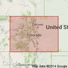
Areal extent of Blue Mesa Tuff in southwestern Colorado shown on distribution map; present in Hinsdale, San Juan and Ouray Counties (San Juan Mountain province), Gunnison County (Piceance basin), and Montrose County (Paradox basin). Is dominantly rhyolite. Erupted from the Lost Lake(?) caldera. Had an estimated volume of 100 to 500 cubic km. Age is more than 27.8 to 28.4 m.y.
Source: Modified from GNU records (USGS DDS-6; Denver GNULEX).
For more information, please contact Nancy Stamm, Geologic Names Committee Secretary.
Asterisk (*) indicates published by U.S. Geological Survey authors.
"No current usage" (†) implies that a name has been abandoned or has fallen into disuse. Former usage and, if known, replacement name given in parentheses ( ).
Slash (/) indicates name conflicts with nomenclatural guidelines (CSN, 1933; ACSN, 1961, 1970; NACSN, 1983, 2005, 2021). May be explained within brackets ([ ]).