

- Usage in publication:
-
- Black River formation
- Modifications:
-
- Revised
- AAPG geologic province:
-
- Michigan basin
Summary:
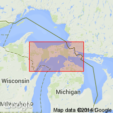
Pg. 13-14, 17-22. Black River formation. Represented by Bony Falls member (new). Underlies Chandler Falls member (new) of Trenton formation. [Age is Middle Ordovician.]
Source: US geologic names lexicon (USGS Bull. 1200, p. 371-373).

- Usage in publication:
-
- Black River Group*
- Modifications:
-
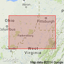
- Areal extent
- AAPG geologic province:
-
- Appalachian basin
Summary:
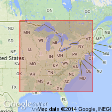
Paleozoic cover sequence adjacent to Adirondack massif in western part of Glens Falls quad consists of (ascending): Late Cambrian Potsdam Sandstone, Late Cambrian Ticonderoga Formation, Late Cambrian and Early Ordovician Beekmantown Group (with Whitehall Formation at base), early Middle Ordovician Chazy Group, Middle Ordovician Black River and Trenton Groups, and Mohawk Valley shales (Canajoharie Shale and Snake Hill Formation). Succession of units is interpreted as a platform sequence.
Source: GNU records (USGS DDS-6; Reston GNULEX).
- Usage in publication:
-
- Black River Group
- Modifications:
-
- Overview
- AAPG geologic province:
-
- Appalachian basin
Summary:
The type Black River Group is composed of (ascending) Pamelia and Lowville Formations. According the Errata sheet and revised Abstract, the Leray Formation (here abandoned) is now recognized as the lower portion of the Watertown Formation. What was originally identified by the author as the Leray, was in fact, the upper part of the Lowville. The paracontinuous boundary of the Blackriveran-Trentonian is therefore the Lowville-Watertown contact. The Chaumont Formation is also suppressed for it is all Trentonian rather than Blackriveran and is here called a "junior synonym" of the Watertown.
Source: GNU records (USGS DDS-6; Reston GNULEX).
- Usage in publication:
-
- Black River Limestone*
- Modifications:
-
- Revised
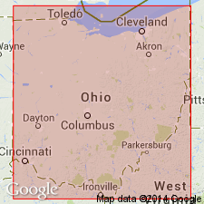
- Areal extent
- AAPG geologic province:
-
- Appalachian basin
Summary:
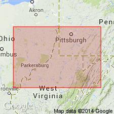
Used in the subsurface of central to eastern OH in cross section D-D'. Lower part is equivalent to St. Paul Group in WV. This usage is also preferred by Ohio Division of Geological Survey. Age is Middle Ordovician (late Chazyan through Rocklandian).
Source: GNU records (USGS DDS-6; Reston GNULEX).
- Usage in publication:
-
- Black River Limestone*
- Modifications:
-
- Overview
Summary:
In section C-C' the Black River Limestone of the subsurface of Ohio is equivalent to the combined Black River Group and Loysburg Formation of Pennsylvania.
Source: GNU records (USGS DDS-6; Reston GNULEX).
- Usage in publication:
-
- Black River Group*
- Modifications:
-
- Revised
- AAPG geologic province:
-
- Appalachian basin
Summary:
In cross section E-E', in subsurface of central WV and western VA, Black River Group consists of gray to greenish-gray, micritic limestone with some shale beds. In WV, follows usage of Cardwell and others (1968; State map), Cable and Beardsley (1984), Prouty and others (1959), and Wagner (1966). Hatter and Benner Limestones of Black River Group not recognized in section. In VA, Black River Group consists of units recognized by Read (1980) and Rader (1982) (ascending order): Lincolnshire Limestone, Ward Cove Limestone, Peery and Benbolt Limestone (undivided), Wardell Formation, and Witten Limestone. Near Harrisonburg, VA, Black River Group not used; that interval represented by the equivalent Lincolnshire Limestone and overlying Liberty Hall Formation (Read, 1980; Rader, 1982); Ward Cove becomes a tongue of the Liberty Hall. Black River Group climbs up section westward and is marked by metabentonite bed. Micritic limestone is called Black River Limestone in Ohio and follows usage of De Bosse and Vohwinkel (1974), Wickstrom and others (1985), and Wickstrom and Gray (1988). Metabentonite also marks top in Ohio. Lower part is equivalent to St. Paul Group in WV. Age of Black River Group is Middle Ordovician (Blackriveran through Rocklandian) in VA and WV. Age of Black River Limestone is Middle Ordovician (late Chazyan through Rocklandian) in OH.
Source: GNU records (USGS DDS-6; Reston GNULEX).
- Usage in publication:
-
- Black River Group
- Modifications:
-
- Overview
- AAPG geologic province:
-
- Appalachian basin
Summary:
According to traditional time-rock classification of North America, the entire Champlainian Series (represented by the Wells Creek Formation through the Trenton Limestone) has always been regarded as Middle Ordovician. The COSUNA charts, however, based on the global system of time-rock classification of European strata assigned most Champlainian-age rocks to the Late Ordovician. Authors of this report do not agree with the assignments of the COSUNA charts and continue to consider the Black River Group and the Trenton Limestone as Middle Ordovician. "Because of lithologic, depositional, and geophysical-log similarities of the rocks in the Black River Group, it is not formally subdivided by the Ohio Division of Geological Survey at this time."
Source: GNU records (USGS DDS-6; Reston GNULEX).
For more information, please contact Nancy Stamm, Geologic Names Committee Secretary.
Asterisk (*) indicates published by U.S. Geological Survey authors.
"No current usage" (†) implies that a name has been abandoned or has fallen into disuse. Former usage and, if known, replacement name given in parentheses ( ).
Slash (/) indicates name conflicts with nomenclatural guidelines (CSN, 1933; ACSN, 1961, 1970; NACSN, 1983, 2005, 2021). May be explained within brackets ([ ]).