

- Usage in publication:
-
- Bingham Mine formation
- Modifications:
-
- Named
- Dominant lithology:
-
- Sandstone
- Limestone
- AAPG geologic province:
-
- Great Basin province
- Wasatch uplift
Summary:
Pg. 2 (table 1), 8-9, pls. 2, 5. Units and names described herein are those used by Kennecott Copper Corp. geologists within Bingham mining district. They are not intended as formal names unless they are applicable. Bingham Mine formation. Name applied to the upper 6,500 feet of the Oquirrh group (rank raised; restricted to Pennsylvanian rocks); crops out in central part of mapped area, Salt Lake County (Wasatch uplift) and Tooele County (Great Basin province), Utah. The quartzitic sandstones (predominant) and limestones of formation are intruded by Bingham stock, a granite porphyry of Tertiary age. Sandstones of formation are rocks known as "Bingham quartzites" in mining district; described as tan, very fine-grained, feldspathic, cross-laminated, siliceous. Subdivided into (ascending) Jordan, Lark, Commercial, Parnell, Petro, Maybe, and Mostest limestone members. Only Jordan and Commercial members are discussed and mapped. Jordan limestone member, 195 feet, is a black to dark-gray, fine-grained, argillaceous, silty, thin-bedded to platy, fossiliferous limestone. Commercial limestone member, a dark-gray to black, very fine-grained, argillaceous, silty, thin-bedded limestone with black nodular chert. Unconformably overlies Butterfield formation (new); unconformably underlies Curry formation (new). Fossil fusulinids of Missourian and Virgilian age identified (listed); no fossils of late Virgilian age were recovered. Age is Late Pennsylvanian (Missourian-Virgilian). Report includes cross section.
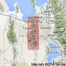
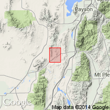
Type section: in secs. 6, 7, 18, 19, 20, and 21, T. 4 S., R. 3 W., and in sec. 12 T. 4 S., R. 4 W., Fairfield, Stockton, and Bingham Canyon quadrangles, UT.
Reference section: north side of West Canyon, opposite Maple Canyon, in north-central part sec. 27 and south-central part sec. 22, T. 4 S., R. 3 W., Fairfield quadrangle, UT.
[Misprint: type and reference sections given in US geologic names lexicon (USGS Bull. 1350, p. 70) are here considered incorrect (based on GNC index card files, ca. 1970).
Misprint: US geologic names lexicon (USGS Bull. 1350, p. 70) indicates the Commercial, Jordan, Parnell, and Petro Limestone Members are all newly named in this report. US geologic names lexicon (USGS Bull. 896, p. 499, 1056, 1606, 1645) indicates Arthur Keith (1905, USGS Prof. Paper 38) introduced the Commercial and Jordan, and inadvertently introduced the Petro (= †Tilden, rocks later reallocated to Butterfield Peaks Formation); Hunt, Winchell, and Peterson (1924, Amer. Inst. Min. and Metal. Engrs. Trans., v. 70) introduced the Parnell.]
Source: US geologic names lexicon (USGS Bull. 1350, p. 70); GNC index card files (USGS-Menlo); GNU records (USGS DDS-6; Denver GNULEX).
- Usage in publication:
-
- Bingham Mine Formation*
- Modifications:
-
- Biostratigraphic dating
- AAPG geologic province:
-
- Great Basin province
Summary:
Pg. A53-A57. Bingham Mine Formation of Oquirrh Group in the Bingham sequence, central and southern Oquirrh Mountains, Tooele County, Utah. Megafossils are scarce and poorly preserved, except for the unusually large assemblage (60 invertebrate species) in Markham beds at locality 1.25 miles west of Lark; brachiopod fauna is very similar to OMPHALOTROCHUS WOLFCAMPENSIS-bearing beds in lower part of Kessler Canyon Formation in the Rogers Canyon sequence. Fusulinds are the most abundant, but many are silicified and show signs of having been reworked; most common are genus TRITICITES. Age is Late Pennsylvanian (Missouri and Virgil), based chiefly on fusulinids.
Source: Publication.
- Usage in publication:
-
- Bingham Mine Formation*
- Modifications:
-
- Revised
- AAPG geologic province:
-
- Great Basin province
Summary:
Pg. A33-A38. Bingham Mine Formation of Welsh and James (1961) adopted as the uppermost of three formations of the Oquirrh Group (rank raised) in the Bingham sequence, central and southern Oquirrh Mountains, Tooele County, Utah. Thickness 7,311 feet; complete thickness not known. Overlies Butterfield Peak Formation (new) of Oquirrh. Includes (ascending) Clipper Ridge and Markham Peak Members (both new). Age is Late Pennsylvanian (Missouri and Virgil), based chiefly on fusulinids. Report includes measured sections, columnar sections, correlation chart.
Source: Publication; Changes in stratigraphic nomenclature, 1970 (USGS Bull. 1354-A, p. A2-A3).
- Usage in publication:
-
- Bingham Mine Formation*
- Modifications:
-
- Biostratigraphic dating
- AAPG geologic province:
-
- Great Basin province
Summary:
In report area (in Great Basin province), the Oquirrh Group includes (ascending) West Canyon Limestone, Butterfield Peaks Formation, and Bingham Mine Formation. Conodonts collected from the West Canyon Limestone suggest an Early Pennsylvanian (Morrowan) age for the formation. Fusulinids collected from the Butterfield Peaks Formation indicate a Middle Pennsylvanian (Atokan and Des Moinesian) age for the formation; latest Atokan to early Des Moinesian fusulinids were recovered from Butterfield Peaks "equivalents," and Des Moinesian fusulinids (MILLERELLA sp, WEDEKINDELLA spp., and BEWEDEINA spp.) were recovered from the upper part of the Butterfield Peaks Formation. Fusulinids from the Bringham Mine Formation are more restricted here than in the Bingham Mining district; Mississippian age TRITICITES recovered from near base, and a younger Virgilian age TRITICITES recovered from stratigraphically higher in the formation [exact level not stated]. Fossils listed. Report includes geologic map showing areal extent of formations.
Source: Modified from GNU records (USGS DDS-6; Denver GNULEX).
- Usage in publication:
-
- Bingham Mine Formation*
- Modifications:
-
- Biostratigraphic dating
- AAPG geologic province:
-
- Great Basin province
Summary:
Pg. 5-6, 13-14, 15-16, pls. 1, 2. Bingham Mine Formation. Is 3,200 feet thick in section measured on east side of Jericho Ridge, in sec. 36, T. 12 S., R. 2-1/2 W. and in sec. 6, T. 13 S., R. 2 W., Furner Ridge quadrangle, Juab County, Utah. Clipper Ridge and Markham Peak Members of the Bingham Canyon area are not recognizable in the East Tintics. Conformably underlies Furner Valley Limestone (new) of Oquirrh Group. Overlies Butterfield Peaks Formation of Oquirrh Group. Seven collections of fusulinids were studied and compared with those from the Bingham Mine at its type. Age is Late Pennsylvanian (Missourian). Report includes fossil plates, correlation chart, measured sections, cross sections, geologic map.
Source: Publication; GNU records (USGS DDS-6; Denver GNULEX).
For more information, please contact Nancy Stamm, Geologic Names Committee Secretary.
Asterisk (*) indicates published by U.S. Geological Survey authors.
"No current usage" (†) implies that a name has been abandoned or has fallen into disuse. Former usage and, if known, replacement name given in parentheses ( ).
Slash (/) indicates name conflicts with nomenclatural guidelines (CSN, 1933; ACSN, 1961, 1970; NACSN, 1983, 2005, 2021). May be explained within brackets ([ ]).