The National Geologic Map Database is migrating to a new infrastructure. We apologize for any service disruptions during this process.
|
|---|


- Usage in publication:
-
- Bighorn limestone*
- Modifications:
-
- Original reference
- Biostratigraphic dating
- Dominant lithology:
-
- Limestone
- AAPG geologic province:
-
- Powder River basin
- Bighorn basin
Summary:
Pg. 394-401. Bighorn limestone. [Recognized in Wyoming and southern Montana.] On east side of Bighorn Mountains, Wyoming, consists of 250 to 300 feet of limestone, in greater part hard and massive. Top member is thin-bedded impure limestone which northwest of Buffalo, Wyoming, contains large Richmond fauna. Middle member is less massive than basal member and in places consists of fine-grained, light-colored limestones containing numerous corals, including HALYSITES CATENULATUS. Lower member is hard, massive, impure limestone, light gray or faint buff, with reticulating network of silica, which on weathering gives it a very coarse honey-combed appearance; contains a few Late Ordovician fossils. [On p. 434 he says the fossils in lower massive member are Trenton.] Underlies Little Horn [Madison] limestone [Lower Mississippian] and overlies Deadwood formation [Upper Cambrian]. [Age is Late Ordovician.]
[See Leigh member of Bighorn dolomite.]
Source: US geologic names lexicon (USGS Bull. 896, p. 185).
- Usage in publication:
-
- Bighorn dolomite*
- Modifications:
-
- Revised
- AAPG geologic province:
-
- Green River basin
Summary:
Pg. 419-420. Bighorn dolomite. From Teton Range eastward at least to middle of Wind River Mountains and north into Absaroka Range, the massive member of well-known Bighorn dolomite is overlain by a thin persistent layer, the Leigh dolomite member. The Leigh is commonly 30 to 40 feet thick, and, in most if not in all localities, is limited both above and below by disconformities. [See Blackwelder 1918 entry under Leigh.]
[Misprint (US geologic names lexicon, USGS Bull. 1200, p. 335): "...the massive member, the Bighorn dolomite, is overlain by a thin persistent layer, the Leigh dolomite member..." should read "...the massive member OF well-known Bighorn dolomite is overlain by a thin persistent layer, the Leigh dolomite member..." (see USGS Bull. 896, p. 1167).]
Source: US geologic names lexicons (USGS Bull. 896, Leigh entry p. 1167; supplemental information from USGS Bull. 1200, p. 334-336).
- Usage in publication:
-
- Bighorn formation
- Modifications:
-
- Biostratigraphic dating
- Revised
- AAPG geologic province:
-
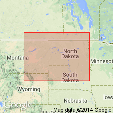
- Wind River basin
Summary:
[Long discussion of faunas of Bighorn dolomite, from which he concludes whole formation is of Richmond age. See under Lander sandstone member.]
Source: US geologic names lexicon (USGS Bull. 896, p. 185).

- Usage in publication:
-
- [Bighorn dolomite]
- Modifications:
-
- Areal extent
- AAPG geologic province:
-
- Wind River basin
Summary:
Pg. 1092. Big Horn [Bighorn] dolomite. In Wind River Canyon area, Wyoming, Big Horn [Bighorn] dolomite overlies Boysen formation (new). [Age is Late Ordovician.]
Source: US geologic names lexicon (USGS Bull. 1200, p. 334-336).
- Usage in publication:
-
- Bighorn dolomite
- Modifications:
-
- Areal extent
- AAPG geologic province:
-
- Bighorn basin
Summary:
Pg. 543, 554 (fig. 2). Bighorn dolomite. In Beartooth Mountains, southern Carbon County, Montana, unconformably overlies newly named Grove Creek formation (Upper Cambrian). Age is Ordovician.
Source: US geologic names lexicon (USGS Bull. 1200, p. 334-336); supplemental information from GNU records (USGS DDS-6; Denver GNULEX).
- Usage in publication:
-
- Bighorn group*
- Modifications:
-
- Revised
- AAPG geologic province:
-
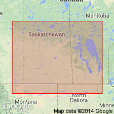
- Williston basin
Summary:
Pg. 446 (fig. 68), 447-448. Bighorn group. Discussion of Ordovician fossils from wells in Willston basin, eastern Montana. Term Bighorn group used to include (ascending) Red River and Stony Mountain formations in subsurface. Overlies Winnipeg formation.
Source: US geologic names lexicon (USGS Bull. 1200, p. 334-336).
- Usage in publication:
-
- Bighorn group
- Modifications:
-
- Revised
- AAPG geologic province:
-
- Williston basin
Summary:
Revised by addition of Stonewall formation as uppermost unit of Bighorn. Ross (1957) included Stonewall in his Stony Mountain formation. Group now consists of (ascending) Red River, Stony Mountain, and Stonewall formations. Stony Mountain is divided into (ascending) Stony Mountain shale [member] [same name should not be applied both to unit as a whole and to part of it] and Gunton member. Cross sections; table of nomenclature. Late Ordovician age.
Source: GNU records (USGS DDS-6; Denver GNULEX).
- Usage in publication:
-
- Bighorn Dolostone*
- Modifications:
-
- Redescribed
- Dominant lithology:
-
- Dolostone
- AAPG geologic province:
-
- Montana folded belt
Summary:
Uses Bighorn Dolostone. In fig. 2 and throughout chapter, "dolostone" is used for rocks composed predominantly of the mineral "dolomite." [Although "dolostone" is the proper term, it has not often been applied to dolomitic formations and members in the literature.] Bighorn Dolostone shown in stratigraphic column of southwest Montana (Montana folded belt province). Unconformably overlies Snowy Range Formation (Upper Cambrian and Lower Ordovician); unconformably underlies Beartooth Butte Formation (Lower Devonian). Age is Late Ordovician (Cincinnatian).
Source: GNU records (USGS DDS-6; Denver GNULEX).
- Usage in publication:
-
- Bighorn Dolomite*
- Modifications:
-
- Areal extent
- AAPG geologic province:
-
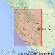
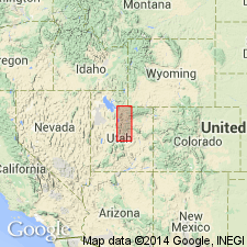
- Uinta uplift
Summary:
Name used for Ordovician rocks on hanging wall of Absaroka thrust fault in Summit Co, UT, Uinta uplift. These are the only Ordovician rocks present along line of section of study area. Bighorn generally restricted to rocks in WY, whereas time-equivalent rocks in north-central UT have been assigned to Fish Haven Dolomite, though nomenclatural boundary has varied in this part of UT. Unconformably underlies Jefferson Formation; unconformably overlies Lynch? Dolomite. Late Ordovician age.
Source: GNU records (USGS DDS-6; Denver GNULEX).
For more information, please contact Nancy Stamm, Geologic Names Committee Secretary.
Asterisk (*) indicates published by U.S. Geological Survey authors.
"No current usage" (†) implies that a name has been abandoned or has fallen into disuse. Former usage and, if known, replacement name given in parentheses ( ).
Slash (/) indicates name conflicts with nomenclatural guidelines (CSN, 1933; ACSN, 1961, 1970; NACSN, 1983, 2005, 2021). May be explained within brackets ([ ]).