

- Usage in publication:
-
- Berea Sandstone*
- Modifications:
-
- Age modified
- Biostratigraphic dating
- AAPG geologic province:
-
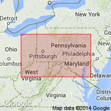
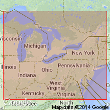
- Appalachian basin
Summary:
This report refutes the ages of Sanford (1967). The species HYMENOZONOTRILETES LEPIDOPHYTUS Kedo, used by Sanford to date the Bedford, Berea, and Sunbury, is not a valid fossil to use because it spans both Late Devonian and Early Mississippian time. The Bedford Shale and Berea Sandstone overlie the Murrysville sand which contains ADIANTITES, an Early Mississippian (Kinderhook) fossil. Therefore, the age of the Berea must be Early Mississippian.
Source: GNU records (USGS DDS-6; Reston GNULEX).
- Usage in publication:
-
- Berea Sandstone*
- Modifications:
-
- Age modified
- Biostratigraphic dating
- AAPG geologic province:
-
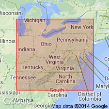
- Appalachian basin
Summary:
The age of the Bedford Shale and the Berea Sandstone is changed from Late Devonian and Early Mississippian to Late Devonian only (late Famennian) in the Michigan and Appalachian Basins because of the realignment of the Devonian-Mississippian boundary in the United States with the accepted Devonian-Carboniferous boundary in Europe. This agrees with the realignment in the Upper Mississippi Valley and the Western United States. Age is Late Devonian based on spores, conodonts, ammonoids, and by the close fit to the Devonian sea-level curve.
Source: GNU records (USGS DDS-6; Reston GNULEX).
- Usage in publication:
-
- Berea Sandstone
- Modifications:
-
- Areal extent
- AAPG geologic province:
-
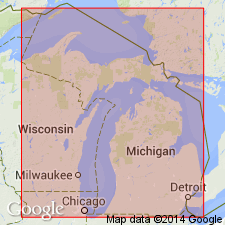
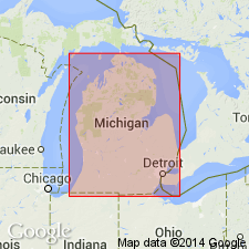
- Michigan basin
Summary:
Bedford Shale and Berea Sandstone are not exposed in MI. They record, in the subsurface, a southwestward growth of a deltaic system into the Antrim sea during Kinderhookian time. The Berea attains a thickness of 79 m in Huron Co. but thins northwestward, westward, and southwestward away from the thumb area and is absent in the eastern half of the Michigan basin. Unit is generally 15 to 30 m throughout its extent. Consists predominantly of light gray sandstone that is fine grained in the lower and upper parts of the formation but medium to coarse grained in the middle. It is silty and pyritic in its lower part.
Source: GNU records (USGS DDS-6; Reston GNULEX).

- Usage in publication:
-
- Berea Sandstone Member
- Modifications:
-
- Revised
- AAPG geologic province:
-
- Appalachian basin
Summary:
In this study, the Chattanooga Shale is divided into (ascending) Rhinestreet Shale, Upper Olentangy Shale, Ohio Shale, Bedford Shale, Berea Sandstone, and Sunbury Shale Members. The Chattanooga thins westward. Geophysical logs indicate that in the western region, the Chattanooga consists of only the Sunbury, Berea-Bedford, and Ohio Members, the Rhinestreet and Olentangy having pinched out. The Berea-Bedford interval is most easily recognized in the eastern and central part of the study area. In the extreme eastern part of the study area, where the interval of Ohio Shale is dominated by gray shale, the Berea-Bedford interval is not recognized because it also is composed mainly of gray shale. The Berea-Bedford interval thickens eastward toward the extreme eastern part of the Pineville strike section and there begins again to thin. According to the author, formal nomenclature presented in this report has been accepted by the Kentucky Stratigraphic Nomenclature Committee. Report includes correlation charts, cross-sections, and measured sections.
Source: GNU records (USGS DDS-6; Reston GNULEX).

- Usage in publication:
-
- Berea Sandstone*
- Modifications:
-
- Areal extent
- AAPG geologic province:
-
- Appalachian basin
Summary:
The Bedford and overlying Berea Sandstone are shown in fig. 40 as undivided in parts of eastern KY and western VA. Bedford Shale extended into western VA and the subsurface of northern TN. The Bedford and Berea show a pattern of vertically increasing grain size. Locally, in northern OH, the Berea fills channels cut in the Bedford. Elsewhere, the boundary is gradational. Bedford-Berea sequence thins from more than 300 ft in northern OH to a feather-edge in central KY. Berea shown on stratigraphic chart as Early Mississippian.
Source: GNU records (USGS DDS-6; Reston GNULEX).
- Usage in publication:
-
- Berea Sandstone*
- Modifications:
-
- Age modified
- AAPG geologic province:
-
- Appalachian basin
Summary:
This report refutes the Late Devonian age of Gutschick and Sandberg (1991). The author wishes to use his 1970 report as the basis for the continued use of an Early Mississippian age for the Berea Sandstone.
Source: GNU records (USGS DDS-6; Reston GNULEX).
- Usage in publication:
-
- Berea Sandstone
- Modifications:
-
- Age modified
- AAPG geologic province:
-
- Appalachian basin
Summary:
Boundary between the rocks of the Mississippian and Devonian periods in PA was changed in 1992 because of a growing list of paleontological evidence. The Berea, Corry, and Knapp are now considered Late Devonian by the Pennsylvania Geological Survey.
Source: GNU records (USGS DDS-6; Reston GNULEX).
For more information, please contact Nancy Stamm, Geologic Names Committee Secretary.
Asterisk (*) indicates published by U.S. Geological Survey authors.
"No current usage" (†) implies that a name has been abandoned or has fallen into disuse. Former usage and, if known, replacement name given in parentheses ( ).
Slash (/) indicates name conflicts with nomenclatural guidelines (CSN, 1933; ACSN, 1961, 1970; NACSN, 1983, 2005, 2021). May be explained within brackets ([ ]).