

- Usage in publication:
-
- Beclabito Member*
- Modifications:
-
- Named
- Dominant lithology:
-
- Sandstone
- Siltstone
- Mudstone
- AAPG geologic province:
-
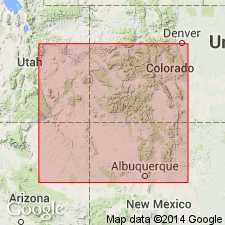
- San Juan basin
- Black Mesa basin
Summary:
Named middle member, Wanakah Formation, San Rafael Group for Beclabito dome, San Juan Co, NM. Type section measured at Horse Mesa which extends from sec 17, T38N, R31E, Apache Co, AZ, Black Mesa basin to secs 26, 27, T29N, R21W, San Juan Co, NM, San Juan basin. Recognized throughout northwest NM and northeast AZ. Name applied to rocks that were formerly assigned to Summerville Formation, term restricted in this report to San Rafael Swell area, UT. Most outcrops examined are on west side of basin. Not identifiable with certainty south of Toadlena. Consists of reddish-orange to reddish-brown sandstone, siltstone, sandy siltstone, mudstone. Sandstone is very fine, fine, and medium grained, well to moderately sorted, subangular to subround. Sedimentary structures consist of ripple cross stratification, small scale trough cross-beds, and wavy, subparallel, horizontal laminations. A thick-bedded to massive, structureless sandstone (35 ft thick at type) at base occupies same stratigraphic position as Bilk Creek Sandstone Member of Wanakah in southwest CO. Siltstone and mudstone are red brown, wavy laminated. Is 108 ft thick at type. Ranges from 125 to 200 ft thick. Overlies Todilto Limestone Member (reduced rank); underlies Horse Mesa Member (new), both of Wanakah. Intertongues with Cow Springs Sandstone. Middle Jurassic age. Deposited on margin of Todilto-Pony Express basin as coastal sabkha-marginal marine unit. Rocks equivalent to Beclabito of se UT.
Source: GNU records (USGS DDS-6; Denver GNULEX).
- Usage in publication:
-
- Beclabito Member*
- Modifications:
-
- Revised
- Overview
- AAPG geologic province:
-
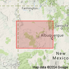
- San Juan basin
Summary:
As the middle member of Middle Jurassic Wanakah Formation of San Rafael Group, Beclabito underlies, in the southeast San Juan basin and Acoma Sag area, the newly named Mesita Member, upper member of the Wanakah. Composed of interbedded reddish-brown to white, silty sandstone, sandy siltstone, and claystone. Forms steep slopes or series of ledges above Todilto Limestone Member of Wanakah. Ranges from 0 in south to 125 ft thick at Mesita. Individual beds have ripple cross-laminations, small-scale cross-bedding, and irregular, subhorizontal wavy laminations or flat-bedding. Is generally very fine to fine grained, but becomes coarser grained to south. Basal beds grade south into chert-pebble conglomerate. Is of marginal marine, sabkha, and fluvial origin. Cross section; nomenclature chart.
Source: GNU records (USGS DDS-6; Denver GNULEX).
- Usage in publication:
-
- Beclabito Member*
- Modifications:
-
- Areal extent
- AAPG geologic province:
-
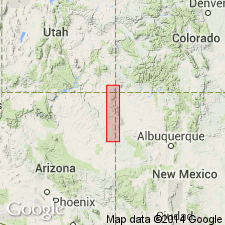
- San Juan basin
- Paradox basin
- Black Mesa basin
Summary:
In the Todilto Park area, the Beclabito Member of Wanakah Formation and the Cow Springs Sandstone intertongue. The Chuska Mountains are used as an arbitrary dividing line between use of Beclabito to north in San Juan Co, NM, San Juan basin, Apache Co, AZ, Black Mesa basin, and San Juan Co, UT (as far north as Bluff), Paradox basin, and use of Cow Springs to south in McKinley Co, NM, San Juan basin.
Source: GNU records (USGS DDS-6; Denver GNULEX).
For more information, please contact Nancy Stamm, Geologic Names Committee Secretary.
Asterisk (*) indicates published by U.S. Geological Survey authors.
"No current usage" (†) implies that a name has been abandoned or has fallen into disuse. Former usage and, if known, replacement name given in parentheses ( ).
Slash (/) indicates name conflicts with nomenclatural guidelines (CSN, 1933; ACSN, 1961, 1970; NACSN, 1983, 2005, 2021). May be explained within brackets ([ ]).