

- Usage in publication:
-
- Aspen formation*
- Modifications:
-
- Original reference
- Dominant lithology:
-
- Shale
- AAPG geologic province:
-
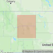
- Green River basin
Summary:
Aspen formation. Black and gray shales containing abundant fish scales. Often weathers silvery gray. Thickness 1,500 to 2,000 feet. Underlies Frontier formation and overlies Bear River formation. Age is Late Cretaceous (Benton age).
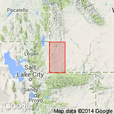
Named from exposures near Old Aspen Station, a now abandoned alinement of the Union Pacific RR, in center of sec. 29, T. 14 N., R. 118 W., [approx. Lat. 41 deg. 09 min. 41 sec. N., Long. 110 deg. 45 min. 03 sec. W., along bdry. btw. Sulphur Creek Reservoir and Piedmont Reservoir 7.5-min quadrangles], Uinta Co., southwestern WY, about 20 mi northeast of southwest corner of the State (see pl. 3, areal geol., scale 1:125,000).
Source: Publication; US geologic names lexicons (USGS Bull. 896, p. 36; USGS Bull. 1200, p. 154-155).
- Usage in publication:
-
- Aspen shale member
- Modifications:
-
- Revised
- AAPG geologic province:
-
- Uinta basin
Summary:
Pg. 97 (table 1), 99 (table 2), 101-102. Aspen shale member of Mancos shale. Member of Mancos shale in Uinta basin, Utah. Overlies a lower unnamed shale member; underlies a middle unnamed shale member. Thickness 15 to 95 feet. Age is Early Cretaceous.
Source: US geologic names lexicon (USGS Bull. 1200, p. 154-155).
- Usage in publication:
-
- Aspen Shale*
- Modifications:
-
- Overview
- AAPG geologic province:
-
- Green River basin
Summary:
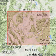
In central part of western Wyoming thrust belt, Greater Green River basin, Aspen Shale and the underlying Bear River Formation of Early Cretaceous age are formations of the eastern sequence above Gannett Group and beneath Frontier Formation. The Quealy, and much of the Sage Junction (both new) Formations are probably the same age (Early Cretaceous) as the Aspen.
Source: GNU records (USGS DDS-6; Denver GNULEX).
- Usage in publication:
-
- Aspen Shale*
- Modifications:
-
- Areal extent
- Overview
- AAPG geologic province:
-
- Uinta uplift
- Green River basin
Summary:
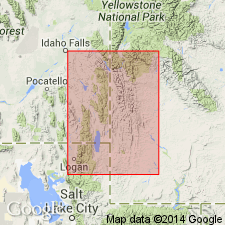
Shows usage in north-central UT. Correlation of sections shows northeast thickening of Aspen from less than 100 m in Coalville area, Summit Co, UT, Uinta uplift to about 550 m in Cumberland Gap area, Lincoln Co, WY, Greater Green River basin. Aspen in Coalville area correlates with middle part of Aspen at Cumberland Gap based on occurrence of Neogastroplites cornutus. Overlies Kelvin Formation and underlies Longwall Sandstone Member of Frontier Formation in Coalville area; overlies Bear River Formation and underlies Frontier at Cumberland Gap. Unit is a marine shale that is part of an eastward prograding shoreline of Mowry Sea across north-central UT. Stratigraphic section. Early Cretaceous age.
Source: GNU records (USGS DDS-6; Denver GNULEX).
- Usage in publication:
-
- Aspen Shale*
- Modifications:
-
- Age modified
- Biostratigraphic dating
- AAPG geologic province:
-
- Green River basin
Summary:
Age modified on basis of biostratigraphic dating. Pseudoceratitic ammonites identified from the upper part of the Aspen Shale southeast of Kemmerer, Lincoln County, Wyoming, in the Greater Green River basin, are believed to be of early Cenomanian age. Present investigation revises the NEOGASTROPLITES zonation of Reeside and Cobban (1960): first, by suggesting that the N. MUELLERI and N. AMERICANUS zones be reversed in their order; and second, by considering that (in descending order) N. MACLEARNI, N. MUELLERI, and N. AMERICANUS zones are early Cenomanian, and that N. CORNUTUS zone may well be early Cenomanian. [See figure by GNULEX Staff (1988) [not available at this time] under unit name "Albian" for comparison of the two zonations. Age of lower part of the Aspen Shale remains late Albian.]
Source: GNU records (USGS DDS-6; Denver GNULEX).
- Usage in publication:
-
- Aspen Formation
- Modifications:
-
- Not used
Summary:
Name no longer used in the Lima region, Beaverhead Co, MT, Montana folded belt province. Use of name Aspen Formation geographically restricted to eastern ID and western WY where it is used in conjunction with the underlying Bear River Formation.
Source: GNU records (USGS DDS-6; Denver GNULEX).
For more information, please contact Nancy Stamm, Geologic Names Committee Secretary.
Asterisk (*) indicates published by U.S. Geological Survey authors.
"No current usage" (†) implies that a name has been abandoned or has fallen into disuse. Former usage and, if known, replacement name given in parentheses ( ).
Slash (/) indicates name conflicts with nomenclatural guidelines (CSN, 1933; ACSN, 1961, 1970; NACSN, 1983, 2005, 2021). May be explained within brackets ([ ]).