

- Usage in publication:
-
- Arnheim bed
- Modifications:
-
- Original reference
- Dominant lithology:
-
- Shale
- Clay
- AAPG geologic province:
-
- Cincinnati arch
Summary:
Pg. 150. Arnheim bed introduced to replace preoccupied name Warren. Consists of shale and clay, with nodular clay layer at top. Thickness 63 feet. Underlies Waynesville bed and overlies Mount Auburn bed [upper part of McMillan formation]. Age is Late Ordovician.
[Named from Arnheim, Brown Co., southwestern OH.]
Source: US geologic names lexicon (USGS Bull. 896, p. 75).

- Usage in publication:
-
- Arnheim shale*
- Modifications:
-
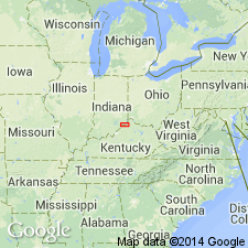
- Areal extent
- Overview
- AAPG geologic province:
-
- Cincinnati arch
Summary:
Arnheim shale. Adopted to include, at top, beds called by A.F. Foerste Fort Ancient division of Waynesville, which because of fauna and stratigraphic break at their top, they more properly belong to the Arnheim than to overlying Waynesville, according to E.O. Ulrich and C. Butts. Foerste also originally stated that his Fort Ancient division is more closely related faunally to Arnheim than to Waynesville. In Ohio, the Arnheim is chiefly shale and is called Arnheim shale. In Indiana and Kentucky, it consists of clay and shale with limestone layers and is called Arnheim formation; in Tennessee, it is wholly limestone and is called Arnheim limestone. Basal formation of Richmond group. Age is Late Ordovician.
Source: US geologic names lexicon (USGS Bull. 896, p. 75).
- Usage in publication:
-
- Arnheim limestone
- Modifications:
-
- Areal extent
- AAPG geologic province:
-
- Cincinnati arch
Summary:
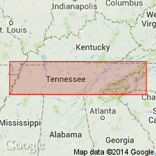
Pg. 31 (table), 74, geol. map. Arnheim limestone. Cherty gray fossiliferous limestone, 0 to 3 feet thick. Unconformably underlies Fernvale formation and unconformably overlies Leipers limestone in south-central Tennessee. Age is Late Ordovician.
Recongized in Clifton area, Wayne Co., south-central TN.
Source: Publication; US geologic names lexicon (USGS Bull. 1200, p. 137-138).
- Usage in publication:
-
- Arnheim formation
- Modifications:
-
- Revised
- AAPG geologic province:
-
- Cincinnati arch
Summary:
Pg. 113. Arnheim formation of Richmond group. Subdivided into into Sunset member below and Oregonia member above. Underlies Waynesville formation; overlies McMillan formation. Richmond group. [Age is Late Ordovician.]
Source: US geologic names lexicon (USGS Bull. 1200, p. 137-138).
- Usage in publication:
-
- Arnheim limestone
- Modifications:
-
- Areal extent
- AAPG geologic province:
-
- Cincinnati arch
Summary:
Arnheim limestone of Richmond group. In proposed changes of nomenclature for Ordovician system of central Tennessee, the Ohio name Arnheim is retained. In case its correlation with strata in Tennessee is seriously questioned, a local name should be applied. Richmond group.
Source: US geologic names lexicon (USGS Bull. 1200, p. 137-138).
- Usage in publication:
-
- Arnheim limestone
- Modifications:
-
- Areal extent
- AAPG geologic province:
-
- Cincinnati arch
Summary:
Pg. 201-207. Arnheim limestone [of Richmond group]. Described as dark-blue to blue-gray, thin-bedded to massive, argillaceous rubbly limestone in Tennessee. Thickness varies from 10 to 20 feet. Overlies Leipers formation unconformably with single known exception of exposure at Clinton where it overlies Hermitage formation. Underlies Sequatchie formation in western exposures. In southeasternmost exposures is overlain by Fernvale limestone. Locally Chattanooga shale rests on Arnheim. [Age is Late Ordovician.]
Source: US geologic names lexicon (USGS Bull. 1200, p. 137-138).
- Usage in publication:
-
- [Arnheim formation]
- Modifications:
-
- Areal extent
- AAPG geologic province:
-
- Cincinnati arch
McFarlan, A.C., and White, W.H., 1952, Boyle-Duffin-Ohio Shale relationships [Kentucky]: Kentucky Geological Survey Bulletin, 9th series, no. 10, 24 p.
Summary:
Pg. 12. [Arnheim formation.] Includes Oregonia member at base of formation in Kentucky. [Age is Late Ordovician (Richmondian).]
Source: US geologic names lexicon (USGS Bull. 1200, p. 137-138).
- Usage in publication:
-
- Arnheim formation
- Modifications:
-
- Revised
- AAPG geologic province:
-
- Cincinnati arch
Summary:
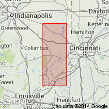
Pl. 1. Arnheim formation of Maysville group. Shown on generalized stratigraphic column of Ordovician and Silurian rocks exposed in Jefferson and Switzerland Counties, [eastern] Indiana (J.J. Galloway, J.B. Patton, and T.G. Perry, compilers, April 1953). Consists of blue soft shale and thin platy limestone. Thickness 70 to 80 feet. Is top formation of Maysville group; overlies Mount Auburn formation. Underlies Waynesville formation of Richmond group. Fossils [listed]. Age is Late Ordovician (Cincinnatian).
Source: Publication; US geologic names lexicon (USGS Bull. 1200, p. 137-138).
- Usage in publication:
-
- Arnheim formation
- Modifications:
-
- Revised
- AAPG geologic province:
-
- Cincinnati arch
Summary:
Pg. 1030. Arnheim formation. If reference section of the Cincinnatian, in Cincinnati region, be considered to include all strata between Point Pleasant (Cynthiana) beds and the Brassfield and their lateral equivalents, it is possible to recognize eight formational units in the sequence. These are (ascending) Eden, Fairview, McMillan, Arnheim, Waynesville, Liberty, Whitewater, and Elkhorn formations. The Arnheim, Waynesville, Liberty, Whitewater, and Elkhorn define the Richmond stage of the Cincinnatian.
Source: US geologic names lexicon (USGS Bull. 1200, p. 137-138).
- Usage in publication:
-
- Arnheim
- Modifications:
-
- Not used
- AAPG geologic province:
-
- Cincinnati arch
Summary:
Tanners Creek Formation (new) replaces the Arnheim, Waynesville, and Liberty formations, which are based on paleontologic criteria and are lithologically indistinguishable.
Source: GNU records (USGS DDS-6; Reston GNULEX).
- Usage in publication:
-
- Arnheim Formation†
- Modifications:
-
- Abandoned
- AAPG geologic province:
-
- Cincinnati arch
Summary:
Name Arnheim Formation (of Foerste, 1905) is here abandoned and its rocks assigned to Sunset and Oregonia Formations (both raised in rank). Units were previously considered members of Arnheim. Lithologic homogeneity of Arnheim is insufficient to meet the requirements of a formation according to the 1983 North American Stratigraphic Code.
Source: GNU records (USGS DDS-6; Reston GNULEX).
- Usage in publication:
-
- Arnheim Formation
- Modifications:
-
- Revised
- AAPG geologic province:
-
- Cincinnati arch
Summary:
The Geological Survey of Ohio recognizes the Cincinnati Group proposed by Meek and Worthen (1865), but at this time retains it as an informal term. The unit will be formally reinstated as a lithostratigraphic term after revision of its lower boundary and minor lithologic redescription of its units are completed. The ten formations included in the group are the (ascending) Clays Ferry Formation, the Kope Formation, the Fairview Formation, the Miamitown Shale, the Grant Lake Limestone, the Arnheim Formation, the Waynesville Formation, the Liberty Formation, the Whitewater Formation, and the Drakes Formation. Six members have been identified in the course of field mapping: the Point Pleasant Tongue of the Clays Ferry, the informal Bellevue, Corryville, Mount Auburn, and Straight Creek members of the Grant Lake Limestone, and the Preachersville Member of the Drakes Formation. The Backbone Creek and Elk Creek beds are recognized as excellent stratigraphic marker beds.
Source: GNU records (USGS DDS-6; Reston GNULEX).

- Usage in publication:
-
- Arnheim Formation*
- Modifications:
-
- Reinstated
- AAPG geologic province:
-
- Cincinnati arch
Summary:
The Arnheim Formation is reinstated in central TN. Unit is not exact equivalent of the Arnheim in OH because the TN unit is Maysvillian and Richmondian. Consists of massive-bedded, argillaceous, rubbly limestone, thin-bedded, nodular, blue-gray limestone, cherty, argillaceous, blue-gray limestone, and gray shale. These facies interbed and intertongue. Contains abundant fossils dominated by brachiopods. Thickness is 10 to 20 feet. Unconformably overlies the Leipers Formation, with the lowermost Arnheim being a red, iron-stained conglomerate, and underlies the Fernvale Limestone. The Arnheim is of Late Ordovician age.
Source: GNU records (USGS DDS-6; Reston GNULEX).
For more information, please contact Nancy Stamm, Geologic Names Committee Secretary.
Asterisk (*) indicates published by U.S. Geological Survey authors.
"No current usage" (†) implies that a name has been abandoned or has fallen into disuse. Former usage and, if known, replacement name given in parentheses ( ).
Slash (/) indicates name conflicts with nomenclatural guidelines (CSN, 1933; ACSN, 1961, 1970; NACSN, 1983, 2005, 2021). May be explained within brackets ([ ]).