The National Geologic Map Database is migrating to a new infrastructure. We apologize for any service disruptions during this process.
|
|---|


- Usage in publication:
-
- Appekunny argillite*
- Modifications:
-
- Original reference
- Dominant lithology:
-
- Argillite
- AAPG geologic province:
-
- Northern Rocky Mountain region
Summary:
Pg. 316, 322. Appekunny argillite. Prevailingly gray, black, and greenish; thin-bedded; ripple marked; interbedded with white quartzite; carries flattened concretions resembling fossils. Thickness 2,000+/- feet. Overlies Altyn limestone. Underlies Grinnell argillite. It is possible more detailed stratigraphic study may develop fact that Grinnell and Appekunny argillites are really phases of one great formation, and that line of distinction between them is one diagonal to the stratification. Age is pre-Cambrian (Belt).
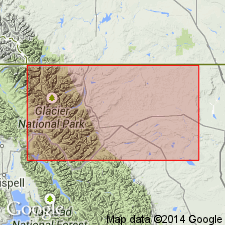
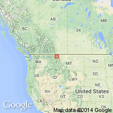
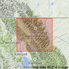
Excellent exposure occurs on northeast spur of Appekunny Mountain, north of Swift Current Valley, Glacier National Park, Glacier Co., northwestern MT, but also well exposed in cliffs throughout Lewis and Livingston Ranges.
Source: US geologic names lexicon (USGS Bull. 896, p. 62).

- Usage in publication:
-
- Appekunny formation
- Modifications:
-
- Revised
- AAPG geologic province:
-
- Northern Rocky Mountain region
Summary:
Pg. 1885-1887. Appekunny formation of Ravalli group. Redefined to exclude Rising Wolf member which is placed in Grinnell formation. As redefined, formation includes following members (ascending): Singleshot, Appistoki, and Scenic Point (new). Consists of argillite interbedded with quartzite, conglomerate, and minor beds of argillaceous limestone; prevailingly green, greenish-gray to brownish, with some dull-red, white, and purplish beds; thin-bedded, with fine laminae; massive only in quartz conglomerates and quartzites; grades into adjacent formation. Thickness in east 2,500 to 5,300 feet; in west as much as 10,000 feet. Underlies Grinnell formation; overlies Altyn formation. [Age is Precambrian (Belt).]
Source: US geologic names lexicon (USGS Bull. 1200, p. 118).

- Usage in publication:
-
- Appekunny Formation*
- Modifications:
-
- Redefined
- AAPG geologic province:
-
- Northern Rocky Mountain region
Summary:
Appekunny Formation of Ravalli Group of Belt Supergroup. Name changed from Appekunny Argillite to Appekunny Formation. Is basal formation of Ravalli Group in Glacier National Park and Whitefish Range, northwestern Montana. Lies below Spokane Formation of Ravalli Group and above Altyn Limestone of Belt Supergroup. Age is Precambrian Y.
Source: Publication; Changes in stratigraphic nomenclature, 1972 (USGS Bull. 1394-A, p. A2-A3).
- Usage in publication:
-
- Appekunny Formation†
- Modifications:
-
- Abandoned
Summary:
†Appekunny Formation of Ravalli Group of Belt Supergroup abandoned. Replaced with Greyson Formation (or Greyson Shale).
[Adopted by the USGS (see Changes in stratigraphic nomenclature, 1977, USGS Bull. 1457-A, p. A5).]
Source: Changes in stratigraphic nomenclature, 1977 (USGS Bull. 1457-A, p. A5).
- Usage in publication:
-
- Appekunny Formation*
- Modifications:
-
- Reinstated
- AAPG geologic province:
-
- Northern Rocky Mountain region
Summary:
Appekunny Formation of Belt Supergroup. Reinstated, after usage of Ross (1959), in Glacier National Park and adjacent areas, Glacier and Flathead Counties, northwestern Montana. Replaces Greyson Formation of Mudge (1977). Best exposure at Apikuni Mountain, in northeastern part of park, where it consists of about 660 m of argillite, siltite, and arenite. Disconformably overlies Altyn Formation on east side of park, and Prichard Formation on west side. Underlies Grinnell Formation. (All of Belt Supergroup.) Age is Middle Proterozoic.
Source: Publication.
For more information, please contact Nancy Stamm, Geologic Names Committee Secretary.
Asterisk (*) indicates published by U.S. Geological Survey authors.
"No current usage" (†) implies that a name has been abandoned or has fallen into disuse. Former usage and, if known, replacement name given in parentheses ( ).
Slash (/) indicates name conflicts with nomenclatural guidelines (CSN, 1933; ACSN, 1961, 1970; NACSN, 1983, 2005, 2021). May be explained within brackets ([ ]).