The National Geologic Map Database is migrating to a new infrastructure. We apologize for any service disruptions during this process.
|
|---|


- Usage in publication:
-
- Antlers sands
- Modifications:
-
- Original reference
- Dominant lithology:
-
- Sand
- AAPG geologic province:
-
- Ouachita folded belt
Summary:
Pg. 303. Pack sand, at base of mountains in southern Indian Territory, identical in character with that of Trinity and Paluxy sands of Brazos section in Texas, except that the limestones which there separate them have thinned out in country north of the Brazos. Uncertain whether it represents either one or both of the sands of Trinity division of Texas, so provisional name Antlers sands is used. [Age is Early Cretaceous (Comanche).]
[Named from Antlers, Pushmataha Co., southeastern OK.]
Source: US geologic names lexicon (USGS Bull. 896, p. 58).
- Usage in publication:
-
- Antlers sand
- Modifications:
-
- Areal extent
- AAPG geologic province:
-
- Fort Worth syncline
Summary:
Pg. 114. Antlers sand will be applied to equivalents of all the formations of Trinity group (Paluxy, Glen Rose, and Travis Peak) as they coalesce along western border region north of Parker County, northeastern Texas. [Age is Early Cretaceous (Comanche).]
Source: US geologic names lexicon (USGS Bull. 896, p. 58).

- Usage in publication:
-
- Antlers sand†
- Modifications:
-
- Abandoned
Summary:
†Antlers sand. This name was many years ago discarded by Oklahoma Geol. Survey and USGS, both of whom employ the older name Trinity sand, for the undifferentiated equivalent of Trinity group of Texas.
Source: US geologic names lexicon (USGS Bull. 896, p. 58).
- Usage in publication:
-
- Antlers sand
- Modifications:
-
- Areal extent
Summary:
Pg. 2333 (fig. 2), 2335. Antlers sand of Trinity group. Correlation chart of Trinity group shows Antlers sand, undifferentiated, in outcrop in southeastern Oklahoma. Antlers is referred to as having Paluxy-like lithology. Paluxy is not included in Trinity as defined in this study. Term Paluxy is restricted to sandstones and shales which are time-stratigraphic equivalent of, and are laterally continuous with, part of Walnut, which is lowest of Fredericksburg group. Age is Early Cretaceous (Comanche).
Source: US geologic names lexicon (USGS Bull. 1200, p. 112).
- Usage in publication:
-
- Antlers sand
- Modifications:
-
- Areal extent
- AAPG geologic province:
-
- Ouachita folded belt
Summary:
Foreword, p. 26, pl. 1. Forgotson (1957) has shown that type Paluxy is Fredericksburg. So-called Paluxy of McCurtain County, Oklahoma, is either upper part of Antlers sand or may be assignable to Rusk sand.
Source: US geologic names lexicon (USGS Bull. 1200, p. 112).

- Usage in publication:
-
- Antlers Sand
- Modifications:
-
- Mapped 1:250k
- Dominant lithology:
-
- Sand
- Clay
- AAPG geologic province:
-
- Ouachita folded belt
Summary:
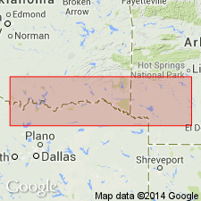
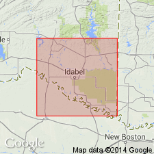
Antlers Sand. Quartz sand, fine-grained, grains well rounded and well-sorted, some lenses of red and gray clay, some gray clay at top, cross-bedded, friable, light-gray to white; weathers various shades of reddish-brown; thickness of outcropping part about 300 feet. Lies below Goodland Limestone. Age is Early Cretaceous; is oldest formal stratigraphic unit in map area.
[Mapped along northern boundary of map sheet, in McCurtain Co., southeastern OK, and Sevier and Howard Cos., southwestern AR. Not mapped in TX.]
Source: Publication.
- Usage in publication:
-
- Antlers Sand
- Modifications:
-
- Mapped 1:250k
- Dominant lithology:
-
- Sand
- Gravel
- AAPG geologic province:
-
- Permian basin
Summary:
Pamphlet [p. 3]. Antlers Sand. Medium-grained, in part loosely consolidated, in part cemented by opal, in part ferruginous, massive, lenses of quartz gravel common, grayish pink to moderate reddish brown. Outcrop thickness of 6 feet at Whalen Lake and 10 feet at Shafter Lake, Andrews County, Texas, where it underlies Ogallala Formation (Pliocene) and overlies Dockum Group, undivided (Triassic). Along southern boundary of map sheet, Winkler-Ector County line, Texas, the Antlers underlies Fredericksburg Group, undivided (Lower Cretaceous). Age is Early Cretaceous.
Source: Publication.

- Usage in publication:
-
- Antlers Sand
- Modifications:
-
- Mapped 1:250k
- Dominant lithology:
-
- Sand
- Clay
- Conglomerate
- AAPG geologic province:
-
- Fort Worth syncline
- South Oklahoma folded belt
Summary:
Pamphlet [p. 6-7]. Antlers Sand (basal Cretaceous or "Trinity Sand"). Sand, clay, and conglomerate. Lower and upper parts chiefly sand; middle part mostly clay; formation grades northward to interbedded sand and clay. Sand, brownish-yellow, weathers to brownish-yellow to locally variegated, fine- to coarse-grained, conglomeratic mostly in lower part, argillaceous in upper part. Clay, red, yellow, in part variegated, interbedded with fine-grained sand. Conglomerate with granule- and pebble-size clasts of chert, quartz, and quartzite. In Oklahoma, sand, white to yellowish-brown, fine- to medium-grained, poorly cemented, ferruginous, cross-bedded, interbeds of varicolored gray, black, and purple ferruginous clay. Thickness 500 to 650 feet. [Correlative with, descending, Paluxy Sand, Glen Rose Limestone, and Twin Mountains Formation, mapped in southwestern corner of map sheet.] Lies above Permian Petrolia Formation of Wichita Group and below Walnut Clay or, where absent, Goodland Limestone. Age is Early Cretaceous.
[Mapped in northern and western parts of map sheet, in Cooke, Grayson, Jack, Montague, and Wise Cos., central northern TX, and Love and Marshall Cos., southeastern OK.]
Source: Publication.

- Usage in publication:
-
- Antlers Sand
- Modifications:
-
- Areal extent
- Dominant lithology:
-
- Sand
- Sandstone
- Conglomerate
- AAPG geologic province:
-
- Permian basin
Summary:
Antlers Sand. Consists of sand, sandstone, and conglomerate. Sand and sandstone, fine- to coarse-grained quartz, locally argillaceous, poorly bedded, moderately indurated to friable, light-gray, grayish-yellow, purple. Conglomerate, basal unit of quartz and clay pebbles with interbeds of coarse sand, ferruginous to slightly calcareous. Thickness 30+/- feet. Lies above Triassic Dockum Group [undivided]. Age is Early Cretaceous.
Not separately mapped. Mapped with Comanche Peak Limestone and Walnut Formation northeast of Posey [Lubbock Co.], southwest of Post [Lynn and Garza Cos.], and on west peak of Double Mountain [Stonewall Co.].
Source: Publication.
For more information, please contact Nancy Stamm, Geologic Names Committee Secretary.
Asterisk (*) indicates published by U.S. Geological Survey authors.
"No current usage" (†) implies that a name has been abandoned or has fallen into disuse. Former usage and, if known, replacement name given in parentheses ( ).
Slash (/) indicates name conflicts with nomenclatural guidelines (CSN, 1933; ACSN, 1961, 1970; NACSN, 1983, 2005, 2021). May be explained within brackets ([ ]).