

- Usage in publication:
-
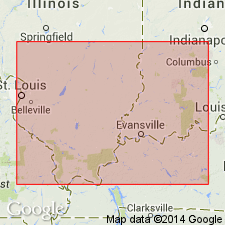
- Allard Member
- Modifications:
-
- Named
- Dominant lithology:
-
- Limestone
- Shale
- AAPG geologic province:
-
- Illinois basin
Summary:
Name Allard Member formally proposed in this report for upper of three members of Menard Formation of Elviran age. Predominantly limestone with some shale. Thickness about 36 ft at type locality. Separated from underlying Scottsburg Member by an unnamed shale. Commonly separated from overlying Palestine Sandstone by 10 to 15 ft of shale.
Source: GNU records (USGS DDS-6; Reston GNULEX).
For more information, please contact Nancy Stamm, Geologic Names Committee Secretary.
Asterisk (*) indicates published by U.S. Geological Survey authors.
"No current usage" (†) implies that a name has been abandoned or has fallen into disuse. Former usage and, if known, replacement name given in parentheses ( ).
Slash (/) indicates name conflicts with nomenclatural guidelines (CSN, 1933; ACSN, 1961, 1970; NACSN, 1983, 2005, 2021). May be explained within brackets ([ ]).