

- Usage in publication:
-
- Pole Creek dacite*
- Modifications:
-
- [First used]
- Dominant lithology:
-
- Dacite
- AAPG geologic province:
-
- Great Basin province
Summary:
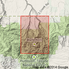
Pg. 304, 306-307. Pole Creek dacite. Medium-gray to black vitrophyre in form of small domical protusions near eastern border of Jarbidge quadrangle. Maximum thickness as much as 900 feet and maximum exposed length about 1.5 miles; parts of masses concealed by gravels. Older than Gods Pocket dacite (new); younger than Robinson Creek vitrophyre. Age is Pliocene(?). Pole Creek Dacite adopted by the USGS.
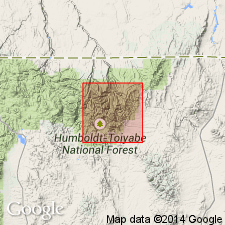
Exposed near eastern border of Jarbidge quadrangle, Elko Co., northeastern NV.
Source: US geologic names lexicon (USGS Bull. 1200, p. 3085).
- Usage in publication:
-
- Pole Creek dacite*
- Modifications:
-
- Named
- Dominant lithology:
-
- Dacite
- AAPG geologic province:
-
- Great Basin province
Summary:
Pole Creek dacite. Medium-gray to black vitrophyre in form of small domical protusions near eastern border of Jarbidge quadrangle. Characterized by numerous oligoclase xenocrysts. Thickness about 900 feet. Younger than Gods Pocket dacite (new); older than Jenny Creek tuff (new). Age is considered Pliocene(?); is contemporaneous with deposition of Slide Creek gravel (new). Report includes geologic map. Adopted by the USGS.
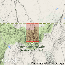
Type locality: in sec. 13, T. 46 N., R. 58 [59] E., Jarbidge quadrangle, Elko Co., northeastern NV. Named from Pole Creek; headwaters are near eastern border of quadrangle.
Source: Modified from GNU records (USGS DDS-6; Denver GNULEX).
- Usage in publication:
-
- Pole Creek Dacite*
- Modifications:
-
- Age modified
- AAPG geologic province:
-
- Great Basin province
Summary:
Age modified from Pliocene? to late Miocene in Jarbidge Wilderness and adjacent areas, north-central Elko Co, NV, Great Basin province. Age change based on 12.2 +/-0.8 m.y. date on Cougar Point Welded Tuff from Owyhee quad about 40 mi to west by Obradovich (Coats, Stephens, 1968, Ore deposits of the United States, 1933-1967, v. 2, p. 1083). Thus all rocks older than Cougar Point and younger than Jarbidge Rhyolite (Gods Pocket Dacite, Pole Creek, Slide Creek Gravel and Jenny Creek Tuff) are assigned late Miocene age.
Source: GNU records (USGS DDS-6; Denver GNULEX).
For more information, please contact Nancy Stamm, Geologic Names Committee Secretary.
Asterisk (*) indicates published by U.S. Geological Survey authors.
"No current usage" (†) implies that a name has been abandoned or has fallen into disuse. Former usage and, if known, replacement name given in parentheses ( ).
Slash (/) indicates name conflicts with nomenclatural guidelines (CSN, 1933; ACSN, 1961, 1970; NACSN, 1983, 2005, 2021). May be explained within brackets ([ ]).