

- Usage in publication:
-
- Minidoka basalt*
- Modifications:
-
- Original reference
- Dominant lithology:
-
- Basalt
- AAPG geologic province:
-
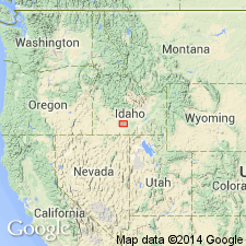
- Snake River basin
Summary:
Pg. 434-439; H.T. Stearns, 1932 (Corr. chart of Idaho compiled by M.G. Wilmarth, dated Sept. 1, 1932). Minidoka basalt. Vesicular, blue, pahoehoe basalt containing tiny crystals of olivine and thinly covered with loess. Thickness 30+/- feet. Overlies conformably the capping gravel member of the beds deposited in lake behind the Sand Spring lava dam. Older than Wendell Grade basalt and younger than Burley lake beds. Age is Pleistocene.
Named from Minidoka dam, Minidoka Co., southern ID. Probably issued from one of cones near Minidoka.
Source: US geologic names lexicon (USGS Bull. 896, p. 1381).
- Usage in publication:
-
- Minidoka basalt*
- Modifications:
-
- Overview
- AAPG geologic province:
-
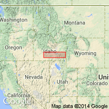
- Snake River basin
Summary:
Pg. 29, 83-84, pl. 4. Minidoka basalt. Thickness about 30 feet. Younger than Burley lake beds and Sand Springs basalt; older than Wendell Grade basalt. Age is Pleistocene, based on vertebrate fossils in an underlying gravel, 11 feet thick, deposited after Burley lake beds.
Extends for 5 mi along north shore of Lake Walcott Reservoir upstream from Minidoka dam.
Source: Publication; US geologic names lexicon (USGS Bull. 1200, p. 2519); GNU records (USGS DDS-6; Denver GNULEX).
For more information, please contact Nancy Stamm, Geologic Names Committee Secretary.
Asterisk (*) indicates published by U.S. Geological Survey authors.
"No current usage" (†) implies that a name has been abandoned or has fallen into disuse. Former usage and, if known, replacement name given in parentheses ( ).
Slash (/) indicates name conflicts with nomenclatural guidelines (CSN, 1933; ACSN, 1961, 1970; NACSN, 1983, 2005, 2021). May be explained within brackets ([ ]).