

- Usage in publication:
-
- Fence River formation*
- Modifications:
-
- Original reference
- Dominant lithology:
-
- Iron-formation
- Quartzite
- Schist
- AAPG geologic province:
-
- Lake Superior region
Summary:
Pg. 14 (table 2), 57-58, pl. 1. Fence River formation. Name applied to magnetic rock exposed at Sholdeis exploration where it consists of (ascending) (1) magnetite-specularite-quartz rock, (2) thinly banded rock rich in quartz, magnetite, hornblende, and epidote, and (3) massive garnet-grunerite schist. Estimated thickness probably as much as 250 feet. Rocks previously assigned to middle Huronian Negaunee iron-formation. Conformably overlies eastward-dipping Hemlock formation; underlies biotite-quartz schist that resembles schists of Hemlock formation. If this schist were considered to be part of the Hemlock, the Fence River would be an upper member of the Hemlock; if the schist is considered a basal member of Michigamme slate, the Fence River is a distinct formation between the Hemlock and Michigamme; the latter view is adopted in this report. Report includes geologic map, magnetic data and profile map, stratigraphic chart. Age is middle Precambrian (upper Huronian).
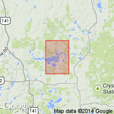
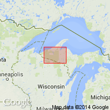
Only known exposure is in SE/4 SE/4 sec. 21, T. 45 N., R. 31 W., [Iron Co.], Northern Peninsula, northwestern MI (Lake Superior region). Formation is represented by strong linear north-trending magnetic anomaly crossing northeastern part of area, on east flank of the Amasa oval, extending northward beyond Kiernan 7.5-min quadrangle to the exposure at Sholdeis exploration. Named from Fence River, which crosses magnetic belt 1,100 feet south of the exploration, in sec. 21, T. 45 N., R. 31 W.
[Misprint: US geologic names lexicon (USGS Bull. 1200, p. 1335) states only known exposure is in Baraga County. Should be Iron County.]
Source: Publication; US geologic names lexicon (USGS Bull. 1200, p. 1335).
- Usage in publication:
-
- Fence River formation*
- Modifications:
-
- Revised
- AAPG geologic province:
-
- Lake Superior region
Summary:
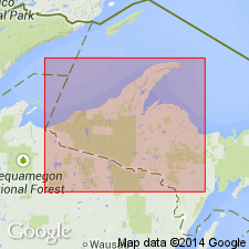
Pg. 30 (table 1), 36. Fence River formation. Assigned to newly defined Baraga group of Animikie series. Exposed only in sec. 21, T. 45 N., R. 31 W., northeast Iron Co., Northern Peninsula, northwestern MI (Lake Superior region); is magnetic and has been traced for many miles on east flank of Amasa oval by magnetic surveys. Not known to be present much south of oval; absence believed to be due to post-Fence River, pre-Michigamme slate erosion. Overlies Hemlock formation of Baraga group. Possibly correlative with Amasa formation of west flank of Amasa oval. Age is middle Precambrian (Animikie Series). Report includes stratigraphic sequence chart.
Source: Publication; US geologic names lexicon (USGS Bull. 1200, p. 1335).
- Usage in publication:
-
- Fence River Formation*
- Modifications:
-
- Revised
- AAPG geologic province:
-
- Lake Superior region
Summary:
Revised--removed from Baraga Group and reassigned to Menominee Group of Marquette Range Supergroup in Iron River and adjacent areas, northern MI in Lake Superior region. Mapped only as part of revised Amasa Formation. Is Proterozoic X in age.
Source: GNU records (USGS DDS-6; Reston GNULEX).
For more information, please contact Nancy Stamm, Geologic Names Committee Secretary.
Asterisk (*) indicates published by U.S. Geological Survey authors.
"No current usage" (†) implies that a name has been abandoned or has fallen into disuse. Former usage and, if known, replacement name given in parentheses ( ).
Slash (/) indicates name conflicts with nomenclatural guidelines (CSN, 1933; ACSN, 1961, 1970; NACSN, 1983, 2005, 2021). May be explained within brackets ([ ]).