

- Usage in publication:
-
- Buckhorn conglomerate
- Modifications:
-
- Original reference
- Dominant lithology:
-
- Conglomerate
- AAPG geologic province:
-
- Paradox basin
Summary:
Pg. 958, 965-966, pl. 4. Buckhorn conglomerate of [/]Cedar Mountain group. A persistent bench former. At type locality, unit is 20 to 30 feet thick, irregularly bedded with minor sandy lentils, but generally present as single massive stratum. Pebbles average about 1.25 inches in diameter; most are black chert, there are few sandstone, shale, or limestone fragments, and igneous rocks are rare. Underlies Cedar Mountain shale (new); overlies Brushy Basin shale member of Morrison. Together with Cedar Mountain shale comprises [/]Cedar Mountain group (new). [No fossils. Age is considered Early Cretaceous(?), based on tentative stratigraphic relations.]
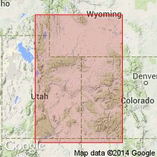
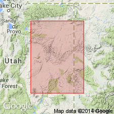
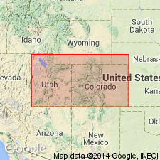
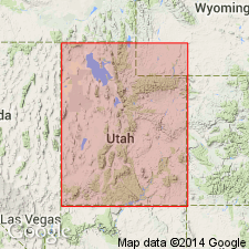
Type locality: Buckhorn Flat, on southwest flank of Cedar Mountain, [Buckhorn Reservoir and Bob Hill Knoll 7.5-min quadrangles], Emery Co., central eastern UT. Prominent in northern part of San Rafael area where it caps Cedar Mountain, a tabular mass of Jurassic sediments about 75 sq mi in extent.
[Cedar Mountain Group in conflict with nomenclatural guidelines stating it is not permissible to apply the same name to a unit and to a part of it (CSN, 1933; ACSN, 1961, 1970; NACSN, 1983, 2005, 2021). Cedar Mountain Group considered invalid.]
Source: Publication; US geologic names lexicon (USGS Bull. 1200, p. 513-514).
- Usage in publication:
-
- Buckhorn conglomerate member
- Modifications:
-
- Revised
- Age modified
- Dominant lithology:
-
- Conglomerate
- AAPG geologic province:
-
- Paradox basin
Summary:
Pg. 1773, 1774, 1775 (fig. 3). Buckhorn conglomerate member of Cedar Mountain formation. Observations have convinced the writer that the Buckhorn may be better regarded as a member of the Cedar Mountain formation because it has discontinuous distribution and is generally too thin to map separately. This revision involves merely a change of status and does not alter the content or rocks or correlations of units involved. Consists of conglomerate with minor sandstone lenses. Constituent pebbles make up 90 percent of total rock and consist predominantly of dark-colored cherts with a few quartzites. Irregularly bedded; forms strong ledge and wide dip slope. Thickness 30 feet. Lies at base of Cedar Mountain formation, beneath unnamed sandstone lenses, limestone beds, and cherts of variable thicknesses and distribution and more or less filling irregularities on top of the Buckhorn. Lies above Morrison formation. [No fossils.] Age is Early Cretaceous, based on stratigraphic relations.
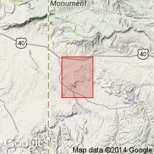
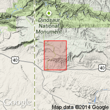
Section measured just below dam of Buckhorn Reservoir, [Emery Co., central eastern UT, see also outcrop photo (pl. 4, fig. 1) in Stokes, 1944].
Source: Publication; US geologic names lexicon (USGS Bull. 1200, p. 513-514).
- Usage in publication:
-
- Buckhorn Conglomerate Member*
- Modifications:
-
- Areal extent
- AAPG geologic province:
-
- Green River basin
Summary:
Is a light- to brownish-gray conglomerate and sandstone at base of Cedar Mountain Formation. 0 to 80 ft thick. Cyclic graded sequence (conglomerate) grades up into cross-bedded, fine-grained sandstone. Mapped in northern part of quad in southern Moffat Co, CO in the Greater Green River basin extending the recognition of the name to north and east of many earlier reports. Of Early Cretaceous age (columnar section). Overlain by shale member of Cedar Mountain. Unconformably underlain by Morrison Formation.
Source: GNU records (USGS DDS-6; Denver GNULEX).
- Usage in publication:
-
- Buckhorn Conglomerate Member*
- Modifications:
-
- Mapped 1:24k (Moffat Co, CO)
- Dominant lithology:
-
- Conglomerate
- Grit
- Sandstone
- AAPG geologic province:
-
- Green River basin
Summary:
Is lower member (of two) of the Cedar Mountain Formation (Lower Cretaceous) mapped in southwest Moffat Co, CO (Greater Green River basin). Unconformably overlies Morrison Formation (Upper Jurassic); underlies upper shale member of the Cedar Mountain Formation. Members are not separately mapped. Buckhorn Conglomerate Member is resistant medium-gray, light-gray, and tan medium-bedded, cross-bedded sandy pebble conglomerate, grit, pebbly sandstone, and fine- to coarse-grained sandstone. As much as 50 percent by volume of the clasts in the Buckhorn Conglomerate Member consist of gray to black chert. Entire formation about 32 m (105 ft) thick--equally divided between the shale member and the Buckhorn Member--on Buckwater Ridge northwest of Gadd Cabin, but is estimated to be as much as 60 m (200 ft) thick elsewhere in the mapped area.
Source: GNU records (USGS DDS-6; Denver GNULEX).
- Usage in publication:
-
- Buckhorn Conglomerate Member*
- Modifications:
-
- Overview
- AAPG geologic province:
-
- Paradox basin
Summary:
Is the basal member of Cedar Mountain Formation. Is a stream deposit composed of lenticular yellow-gray scour-fill sandstone with some granular cobble conglomerate. Overlies Brushy Basin Member of Morrison Formation. Underlies upper shale member of Cedar Mountain. Is late or latest Early Cretaceous on basis of palynomorphs near top of upper member. Report area covers Paradox basin area.
Source: GNU records (USGS DDS-6; Denver GNULEX).
- Usage in publication:
-
- Buckhorn Conglomerate Member
- Modifications:
-
- Age modified
Summary:
Fission-track data give an age of 105.7 +/-7.1 m.y. for bentonites directly below Buckhorn Conglomerate Member of Cedar Mountain Formation; an age of 134.7 +/-5.5 m.y. 15 m below Buckhorn; an age of 133.8 +/-9.3 m.y. 25 m below Buckhorn; and 134.3 +/-6.7 m.y. 30 m below Buckhorn [suggesting that the Upper Jurassic-Lower Cretaceous boundary is within, rather than at the top of, Morrison Formation].
Source: GNU records (USGS DDS-6; Denver GNULEX).
- Usage in publication:
-
- Buckhorn Conglomerate Member*
Kirkland, J.I., Britt, Brooks, Burger, A.M., Carpenter, G.L., Cieutat, B.A., Decatur, S.H., Eaton, J.G., Hasiotis, S.T., and Lawton, T.F., 1997, Lower to middle Cretaceous dinosaur faunas of the central Colorado Plateau; A key to understanding 35 million years of tectonics, sedimentology, evolution, and biogeography: Brigham Young University Geology Studies, v. 42, pt. 2, p. 69-103.
Summary:
Pg. 73. Buckhorn Conglomerate Member of Cedar Mountain Formation. Trough cross-bedded, pebble conglomerate. Thickness 7.5 m at type locality; exposures are discontinuous. Is basal member of Cedar Mountain Formation. Lies beneath Ruby Ranch Member (new) of Cedar Mountain Formation and above Morrison Formation. No fossils. Age is [tentatively] considered Early Cretaceous (Barremian to Aptian), based on stratigraphic relations.
Source: Publication.
For more information, please contact Nancy Stamm, Geologic Names Committee Secretary.
Asterisk (*) indicates published by U.S. Geological Survey authors.
"No current usage" (†) implies that a name has been abandoned or has fallen into disuse. Former usage and, if known, replacement name given in parentheses ( ).
Slash (/) indicates name conflicts with nomenclatural guidelines (CSN, 1933; ACSN, 1961, 1970; NACSN, 1983, 2005, 2021). May be explained within brackets ([ ]).