

- Usage in publication:
-
- Bell Creek Gneiss*
- Modifications:
-
- Overview
- Dominant lithology:
-
- Gneiss
- AAPG geologic province:
-
- Lake Superior region
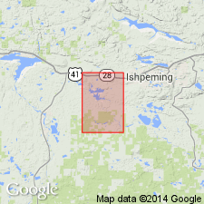
Summary:
Is mapped as two units in Marquette Co, Upper Michigan Peninsula (Lake Superior region). Granitic gneiss forms 80-90 percent of unit; remainder mostly mafic gneiss with small amounts of metamorphosed iron-formation and very small amounts of quartzose metasedimentary? rock. Granitic gneiss: coarse-grained porphyritic rock, mostly adamellite with lesser amounts of granodiorite, rare tonalite and granite; well-aligned large (about 5 cm) grains of microcline microperthite, commonly Carlsbad twins, form about 1/3 of rock; groundmass (grains 2-5 mm) of equant anhedral grains of quartz, plagioclase (generally oligoclase), and microcline microperthite; biotite ubiquitous (as much as 10 percent); chlorite, zircon, and apatite also common; opaque minerals rare; layering in some outcrops from variable amounts of large microcline microperthite grains; small amounts of finer grained granite and quartz-mica schist. Mafic gneiss: dark-colored banded to massive plagioclase (An50-70)-green-brown hornblende-clinopyroxene gneiss having medium-grained granoblastic texture; accessory apatite, ilmenite, sphene, and magnetite; locally, partly or totally retrograded with green hornblende replacing green-brown hornblende and clinopyroxene; locally with thin lenses of iron-formation that is banded to massive grunerite-Fe-rich orthopyroxene-magnetite-quartz rock; occurs as sheets concordant to foliation of granitic gneiss. Precambrian W.
Source: GNU records (USGS DDS-6; Reston GNULEX).

- Usage in publication:
-
- Bell Creek Gneiss*
- Modifications:
-
- Overview
- AAPG geologic province:
-
- Lake Superior region
Summary:
Is present in western upper MI in the Lake Superior region. Occurs over a broad area south of Marquette district in the southern complex of Van Hise and Bayley (1895). Gneisses are very coarse grained, mega-crystic rocks of granitic to granodioritic composition. Is intruded by parts of Compeau Creek Gneiss along north edge of Southern complex. Correlation chart. Locally affected by Proterozoic thermal events, but is assigned a Late Archean age.
Source: GNU records (USGS DDS-6; Reston GNULEX).
For more information, please contact Nancy Stamm, Geologic Names Committee Secretary.
Asterisk (*) indicates published by U.S. Geological Survey authors.
"No current usage" (†) implies that a name has been abandoned or has fallen into disuse. Former usage and, if known, replacement name given in parentheses ( ).
Slash (/) indicates name conflicts with nomenclatural guidelines (CSN, 1933; ACSN, 1961, 1970; NACSN, 1983, 2005, 2021). May be explained within brackets ([ ]).