

- Usage in publication:
-
- Yucca Mountain Member*
- Modifications:
-
- Named
- Dominant lithology:
-
- Tuff
- AAPG geologic province:
-
- Great Basin province
Summary:
Pg. B74-B78. Yucca Mountain Member of Piapi Canyon Formation. Name proposed for 1 of 6 members of Piapi Canyon; was previously unrecognized. Is a nonwelded to densely welded ash-flow tuff sheet. A distinctly uniform shard tuff that has small amounts of pumice (3-4 percent), phenocrysts, and lithic inclusions. Phenocryst content is mainly alkali feldspar, some oligoclase. Quartz and mafic minerals are scarce. Its uniform character contrasts with other sheets in the Piapi Canyon. Immediately underlies Tiva Canyon Member. Conformably overlies thick sequence of bedded tuffs correlative with Survey Butte Member. Distribution map shows known areal extent and thickness. Underlies entire west-central part of Topopah Spring 15-minute quadrangle. Depositional edge present almost continuously around east and west sides of Yucca Mountain. Thickness more than 200 feet at Yucca Mountain; less than 100 feet at southern Shoshone Mountain; thins to east and south and wedges out into Piapi Canyon. Maximum thickness 250 feet near type locality. Piapi Canyon has been dated (K-Ar method) at about 13 Ma. Report includes chemical analyses.
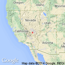
Type locality: northwest end of mesa-like part of Yucca Mountain, in vicinity of southwestern part of Nevada Test Site, Topopah [Spring] 15-min quadrangle, Nye Co., southern NV (Great Basin province). Named from Yucca Mountain.
[Misprint: US geologic names lexicon (USGS Bull. 1350, p. 844) states type locality is in Topopah quadrangle; should be Topopah Spring.]
Source: GNU records (USGS DDS-6; Denver GNULEX); US geologic names lexicon (USGS Bull. 1350, p. 843-844).
- Usage in publication:
-
- Yucca Mountain Member*
- Modifications:
-
- Revised
- AAPG geologic province:
-
- Great Basin province
Summary:
Is one of five named members reassigned from Piapi Canyon Formation to Paintbrush Tuff (new) of Piapi Canyon Group (rank raised) that is recognized in the western and northern parts of the Nevada Test Site, Nye Co, NV in the Great Basin province. Underlies Tiva Canyon Member of Paintbrush. Is separated from the older newly named Pah Canyon Member of Paintbrush by some unnamed bedded tuffs of Paintbrush. Is not present in the Frenchman Flat and Yucca Flat areas. Paintbrush is assigned (and thus all its members are assigned) a Miocene? and Pliocene age. Stratigraphic chart. Cross section. Term Oak Spring as a formation or as a group abandoned.
Source: GNU records (USGS DDS-6; Denver GNULEX).
- Usage in publication:
-
- Yucca Mountain Member*
- Modifications:
-
- Overview
- Areal extent
- AAPG geologic province:
-
- Great Basin province
Summary:
Is a simple cooling unit--one of four named members of Paintbrush Tuff consisting of uniform nearly phenocryst-free, high silica rhyolite. Erupted from the Claim Canyon cauldron. Distribution map; present at northeast, southeast and southwest sides of the Timber Mountain caldera in southern Nye Co, NV in the Great Basin province. About 8 cubic km is present outside the cauldron and an equal volume present within the Claim Canyon cauldron segment where it is 335 m thick. Has less than 1 percent phenocrysts--largely sodic sanidine. Sparse pumice lenticles and gray-red xenoliths less than 1 cm long strewn through matrix of shards or devitrified groundmass. Overlies unnamed bedded tuff of Paintbrush. Underlies Tiva Canyon Member of Paintbrush. Stratigraphic chart. Pliocene age. Modal analyses.
Source: GNU records (USGS DDS-6; Denver GNULEX).

- Usage in publication:
-
- Yucca Mountain Tuff*
- Modifications:
-
- Revised
- AAPG geologic province:
-
- Great Basin province
Summary:
Within southwest Nevada volcanic field, Nye Co, NV, Great Basin province, units previously of formation rank are raised to group rank to allow for combining petrographically, geochemically, and temporally related lava flows and nonwelded tuffs with the principal correlative welded ash-flow tuff sheets (formerly members of the previous formation-rank tuffs). The ash-flow sheets are raised to formation rank and designated as "Tuff." Yucca Mountain is third unit from base of four formal formation-rank units of Paintbrush Group (rank raised). [Paintbrush also consists of informal units not discussed in this report.] Older than Tiva Canyon Tuff (rank raised) of Paintbrush; younger than Pah Canyon Tuff (rank raised) of Paintbrush. Nomenclature shown on table 1. Miocene age.
Source: GNU records (USGS DDS-6; Denver GNULEX).
For more information, please contact Nancy Stamm, Geologic Names Committee Secretary.
Asterisk (*) indicates published by U.S. Geological Survey authors.
"No current usage" (†) implies that a name has been abandoned or has fallen into disuse. Former usage and, if known, replacement name given in parentheses ( ).
Slash (/) indicates name conflicts with nomenclatural guidelines (CSN, 1933; ACSN, 1961, 1970; NACSN, 1983, 2005, 2021). May be explained within brackets ([ ]).