

- Usage in publication:
-
- Wishbone formation*
- Modifications:
-
- Named
- Dominant lithology:
-
- Conglomerate
- Sandstone
- Claystone
- AAPG geologic province:
-
- Alaska Southern region
Summary:
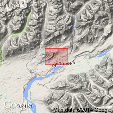
Named for exposure on Wishbone Hill, Matanuska coal field, southern AK. Name first used on correlation chart (Payne, 1955). Rocks formerly lower conglomeratic beds mapped as part of Eska conglomerate by Martin and Katz (1912). Consists predominantly of conglomerate composed of pebbles, cobbles, and few boulders in sandy matrix. Includes lenticular beds of sandstone and lenses of silty claystone. Maximum thickness is 1850 ft. Overlies Chickaloon formation with gradational contact; unconformably underlies Tsadaka formation (new). Age considered to be probably Paleocene or possibly early Eocene.
Source: GNU records (USGS DDS-6; Menlo GNULEX).
- Usage in publication:
-
- Wishbone Formation*
- Modifications:
-
- Age modified
- Biostratigraphic dating
- AAPG geologic province:
-
- Alaska Southern region
Summary:
Correlation chart shows age of Wishbone Formation to be Paleocene and early Eocene based on plant fossils.
Source: GNU records (USGS DDS-6; Menlo GNULEX).
- Usage in publication:
-
- Wishbone Formation*
- Modifications:
-
- Age modified
- AAPG geologic province:
-
- Alaska Southern region
Summary:
Unit age is Eocene based on regional relations (radiometric ages and fossils from overlying and underlying units).
Source: GNU records (USGS DDS-6; Menlo GNULEX).
For more information, please contact Nancy Stamm, Geologic Names Committee Secretary.
Asterisk (*) indicates published by U.S. Geological Survey authors.
"No current usage" (†) implies that a name has been abandoned or has fallen into disuse. Former usage and, if known, replacement name given in parentheses ( ).
Slash (/) indicates name conflicts with nomenclatural guidelines (CSN, 1933; ACSN, 1961, 1970; NACSN, 1983, 2005, 2021). May be explained within brackets ([ ]).