- Usage in publication:
-
- Winterhaven Formation*
- Modifications:
-
- Named
- Dominant lithology:
-
- Dacite
- Sandstone
- Siltstone
- AAPG geologic province:
-
- Salton basin
- Basin-and-Range province
Summary:
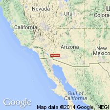
Name applied to a 450 m thick unit that rests on and interfingers with Jurassic rhyodacitic metavolcanic rocks, is unconformably overlain by Oligocene to Holocene rocks, and is intruded by the post-163 m.y. granite of Marcus Wash. Named [presumably] for Winterhaven, a town on west side of Colorado River in Imperial Co, CA in Salton basin. Extends eastward into adjoining Yuma Co, AZ in Basin-and-Range province. Occurs in parts of the Chocolate Mountains, CA, and Picacho-Peter Kane Mountains, CA-AZ, and in parts of Middle and Castle Dome Mountains, and on Neversweat Ridge, AZ. Distribution maps, geologic maps, stratigraphic columns. Type section is on northern limb of anticline just west of Little Picacho Wash, southwest corner Picacho SW quad. Divided into (ascending): basal dacite; middle quartz arenite; and upper argillitic siltstone members. The dacite is massive, purple, brown, altered, aphanitic to sparsely porphyritic rock of intermediate composition 80+ m thick; was probably a lava flow; local breccia at top. The arenite is brown, tan, white quartz and feldspathic, well-indurated, fine to coarse grained, laminated to medium bedded to massive, about 60 m thick. The siltstone is purple, brown, slightly calcareous, massive, about 300 m thick. Jurassic(?) age assigned. May correlate with part of McCoy Mountains Formation. Tectonic importance described.
Source: GNU records (USGS DDS-6; Denver GNULEX).
For more information, please contact Nancy Stamm, Geologic Names Committee Secretary.
Asterisk (*) indicates published by U.S. Geological Survey authors.
"No current usage" (†) implies that a name has been abandoned or has fallen into disuse. Former usage and, if known, replacement name given in parentheses ( ).
Slash (/) indicates name conflicts with nomenclatural guidelines (CSN, 1933; ACSN, 1961, 1970; NACSN, 1983, 2005, 2021). May be explained within brackets ([ ]).

