

- Usage in publication:
-
- Williamsport sandstone
- Modifications:
-
- Named
- Dominant lithology:
-
- Sandstone
- AAPG geologic province:
-
- Appalachian basin
Summary:
Hard, compact greenish-brown or reddish-brown sandstone included in Bloomsburg red shales in this region, here named Williamsport sandstone. Unit is massive and fine-grained with marine fossils. Thickness ranges from 5 to 50 ft. Where beds of Bloomsburg have been eroded, underlies Rondout waterline and overlies Niagara limestone.
Source: GNU records (USGS DDS-6; Reston GNULEX).
- Usage in publication:
-
- Williamport sandstone
- Modifications:
-
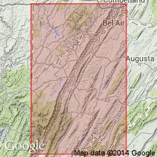
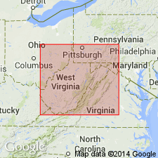
- Areal extent
- Revised
- AAPG geologic province:
-
- Appalachian basin
Summary:
Williamsport sandstone of Reger (1924) is here redefined as a formation. Unit is no longer considered to be part of Bloomsburg shale and is here assigned as basal member of Cayugan group. Its identity in eastern Silurian outcrops is obliterated by, or absorbed in, red nonmarine Bloomsburg facies. Unit is geographically extended to MD. Near Cumberland it includes the Cedar Cliff limestone member (reallocated from Wills Creek) near middle. Abruptly overlies calcareous shales of McKenzie formation; sharply underlies Wills Creek limestone. Unit is also present in VA, however, the unit is more a zone of sandstones rather than a distinct siliceous body and contacts are gradational.
Source: GNU records (USGS DDS-6; Reston GNULEX).
For more information, please contact Nancy Stamm, Geologic Names Committee Secretary.
Asterisk (*) indicates published by U.S. Geological Survey authors.
"No current usage" (†) implies that a name has been abandoned or has fallen into disuse. Former usage and, if known, replacement name given in parentheses ( ).
Slash (/) indicates name conflicts with nomenclatural guidelines (CSN, 1933; ACSN, 1961, 1970; NACSN, 1983, 2005, 2021). May be explained within brackets ([ ]).