The National Geologic Map Database is migrating to a new infrastructure. We apologize for any service disruptions during this process.
|
|---|


- Usage in publication:
-
- Wild Sheep Creek Formation
- Modifications:
-
- First used
- Dominant lithology:
-
- Basalt
- Breccia
- Volcaniclastics
- AAPG geologic province:
-
- Blue Mountains province
Summary:
[First used] as third from oldest formation in Seven Devils Group, forming Seven Devils Volcanics of Anderson (1930). Name replaces Imnaha Formation (Wetherell, 1960), Grassy Ridge Formation (Vallier, 1967) and volcanic sedimentary sequence (Morrison, 1963). Consists of basalt and possibly basaltic andesite, massive lava flows, pillow lava, pillow breccia, and aquagene tuff with volcanic breccia, volcanic sandstone, graywacke, limestone and argillite. Thickness ranges from 2,000 to 2,500 m. Unconformably(?) underlies Pittsburg Formation, and locally, conformably underlies Doyle Creek Formation (both of Seven Devils Group). Unconformably overlies Hunsaker Creek Formation (new) of Seven Devils Group. Age is late Middle Triassic (middle and late Ladinian), based on occurrence of DAONELLA and early Late Triassic (early Karnian) based on ammonite identification (N.J. Silberling, written commun., 1965).
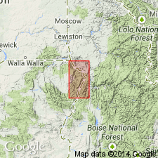
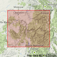
Best section is along north side of Bull Creek in Wild Sheep Creek-Bull Creek area, about 8 km north of Hells Canyon Dam in Snake River Canyon area, Oregon, and Idaho. Reference sections are north of Saddle Creek and in Cherry Creek drainage basin.
[Bit of a confusing GNU discrepancy. GNU staff (1996) credited both this and Vallier (1977) as "naming papers". To simplify matters, I reclassified this as a "First use" paper, and the Vallier (1977) as the "naming paper". There seems to be more derivation of name and type section information in the latter.]
Source: GNU records (USGS DDS-6; Menlo GNULEX).
- Usage in publication:
-
- Wild Sheep Creek Formation
- Modifications:
-
- Overview
- AAPG geologic province:
-
- Blue Mountains province
- Columbia basin
Summary:
Included as third oldest (of 4) formations in Seven Devils Group. Described as gray-green to black volcaniclastic rocks (volcanic breccia, graywacke, limestone, limy shale and conglomerate) and 10 to 15 percent flow rocks (keratophyre and spilite) up to 4,000 ft thick. Unconformably underlies Doyle Creek Formation and Columbia River Basalt. Is in fault contact with Martin Bridge Formation. Unconformably overlies Hunsaker Creek Formation. Age is Triassic.
Source: GNU records (USGS DDS-6; Menlo GNULEX).
- Usage in publication:
-
- Wild Sheep Creek Formation
- Modifications:
-
- Overview
- AAPG geologic province:
-
- Blue Mountains province
- Columbia basin
Summary:
Type section measured at Saddle creek is 830 m thick. Stratigraphic correlation chart shows relationships to Columbia River Basalt, Doyle Creek, Hunsaker Creek Formation and basement complex from Homestead Creek to Grande Ronde River.
Source: GNU records (USGS DDS-6; Menlo GNULEX).
- Usage in publication:
-
- Wild Sheep Creek Formation*
- Modifications:
-
- Named
- Reference
- Dominant lithology:
-
- Basalt
- Andesite
- Argillite
- Graywacke
- Limestone
- AAPG geologic province:
-
- Eastern Columbia basin
Summary:
Named as third (from base) of four new formations assigned to Seven Devils Group (rank raised). Best exposures are in Bull and Saddle Creeks, Wallowa Co, OR. Named for Wild Sheep Creek. Type section designated at spur north of mouth of Saddle Creek, across Snake River from NE1/4 sec 30, T24N, R2W, OR, in the Eastern Columbia basin, where 830 m measured. Reference section designated in Snake River Canyon, near north edge Deadhorse Ridge 7 1/2 min quad, Wallowa Co, OR, where 440 m measured. Forms rugged, dark-green to green-black outcrops. Composed of metamorphosed basalt, basaltic andesite, and andesite. Includes argillite, graywacke, and limestone that increase in abundance to north. Major lithologies are massive lava flows, pillow lavas, flow and pillow breccia, and volcaniclastic rocks. Estimated to be 2,500 m thick. Chemical and modal analyses. Geologic map. Stratigraphic column. Unconformably overlies 1) Hunsaker Creek Formation (new) of Seven Devils Group in southern part of Snake River Canyon, 2) gabbro and quartz diorite south of Wallowa Mountains, and 3) Clover Creek Greenstone in Wallowa Mountains. Is conformably overlain by Doyle Creek Formation (new) of Seven Devils and unconformably overlain by Coon Hollow Formation in northern part of Snake River Canyon. Of latest Middle Triassic or Ladinian on basis of DAONELLA and early Late Triassic, or Karnian on basis of ammonites.
Source: GNU records (USGS DDS-6; Denver GNULEX).
For more information, please contact Nancy Stamm, Geologic Names Committee Secretary.
Asterisk (*) indicates published by U.S. Geological Survey authors.
"No current usage" (†) implies that a name has been abandoned or has fallen into disuse. Former usage and, if known, replacement name given in parentheses ( ).
Slash (/) indicates name conflicts with nomenclatural guidelines (CSN, 1933; ACSN, 1961, 1970; NACSN, 1983, 2005, 2021). May be explained within brackets ([ ]).