The National Geologic Map Database is migrating to a new infrastructure. We apologize for any service disruptions during this process.
|
|---|


- Usage in publication:
-
- West Elk breccia*
- Modifications:
-
- Original reference
- Dominant lithology:
-
- Breccia
- AAPG geologic province:
-
- Piceance basin
Summary:
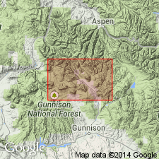
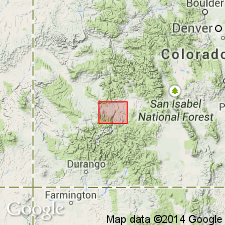
[Credited to G.H. Eldridge, "Description of the Elk Mountains" section.] West Elk breccia. Coarse volcanic breccia alternating with finer ash and tuff. Lower part of what is mapped as West Elk breccia may possibly be more properly considered a sedimentary formation, but observations made do not permit a distinction between such material and the breccia. Forms West Elk Mountains and extends south to Gunnison River, [Anthracite-Crested Butte region, western central Colorado]. Is overlain by rhyolitic lavas near Gunnison. Age is Tertiary (Miocene?).
Source: US geologic names lexicon (USGS Bull. 896, p. 2305).
- Usage in publication:
-
- West Elk Breccia*
- Modifications:
-
- Age modified
- AAPG geologic province:
-
- Piceance basin
Summary:
Age changed from Miocene? to Oligocene or older in West Elks, CO of Piceance basin. Formed at same time as Conejos Quartz Latite of the Conejos River area in San Luis basin, and Lake Fork Formation of the Lake Fork of Gunnison River in Piceance basin, and before the explosive eruptions that began with Blue Mesa Tuff of Oligocene age.
Source: GNU records (USGS DDS-6; Denver GNULEX).
For more information, please contact Nancy Stamm, Geologic Names Committee Secretary.
Asterisk (*) indicates published by U.S. Geological Survey authors.
"No current usage" (†) implies that a name has been abandoned or has fallen into disuse. Former usage and, if known, replacement name given in parentheses ( ).
Slash (/) indicates name conflicts with nomenclatural guidelines (CSN, 1933; ACSN, 1961, 1970; NACSN, 1983, 2005, 2021). May be explained within brackets ([ ]).